


Santini/d'Anville: Map of Canada Great Lakes, 1784
Similar Sale History
View More Items in Maps & Atlases


Related Maps & Atlases


![1893 Civil War Map of Yorktown -- Secession Works at Yorktown [with] The Position of Yorktown with: Title: 1893 Civil War Map of Yorktown -- Secession Works at Yorktown [with] The Position of Yorktown with the Approaches [Plate XV] Cartographer: US War Department Year / Place: 1893 Map Dimension (in](https://p1.liveauctioneers.com/5584/331064/178466378_1_x.jpg?height=310&quality=70&version=1716924723)
![1893 Civil War Map of Knoxville Area -- Topographical Map of the Approaches and Defences of: Title: 1893 Civil War Map of Knoxville Area -- Topographical Map of the Approaches and Defences of Knoxville, E. Tennessee… [with] Map No. 1 The Chickamauga Campaign... [Plate XLVIII] Cartograph](https://p1.liveauctioneers.com/5584/331064/178466410_1_x.jpg?height=310&quality=70&version=1716924723)


![1893 Civil War Map of Siege of Yorktown, Battle of Siloh and Army of Ohio Operations -- Plan of: Title: 1893 Civil War Map of Siege of Yorktown, Battle of Siloh and Army of Ohio Operations -- Plan of Siege of Yorktown [with] Battle Field of Shiloh [with] Line of Operations of the Army of the Ohio](https://p1.liveauctioneers.com/5584/331064/178466356_1_x.jpg?height=310&quality=70&version=1716924723)
![1893 Civil War Map Washington, Paducah, KY and Logan's Cross-Roads plus Mill Springs, KY -- Defenses: Title: 1893 Civil War Map Washington, Paducah, KY and Logan's Cross-Roads plus Mill Springs, KY -- Defenses of Washingto [with] Sketch of Paducah [with] …Mill's Springs, KY… [with] Logan's](https://p1.liveauctioneers.com/5584/331064/178466336_1_x.jpg?height=310&quality=70&version=1716924723)


More Items in Maps & Atlases
View More
![[MAP]. TODESCHI, Pietro. [Nova et Acurata Totius Americae Tabula auct. G.I. Blaeu] America quarta: [MAP]. TODESCHI, Pietro. [Nova et Acurata Totius Americae Tabula auct. G.I. Blaeu] America quarta pars orbis quam plerunq, nuvum orbem appellitant primo detecta est anno 1492 a Christophoro Columbo...](https://p1.liveauctioneers.com/197/329395/177650542_1_x.jpg?height=310&quality=70&version=1715364962)


![[MAPS]. HOMANN, Johann Baptist, HOMANN HEIRS, and Georg Matthäus SEUTTER. [Composite Atlas].: [MAPS]. HOMANN, Johann Baptist (1663-1724), HOMANN HEIRS, and Georg Matthäus SEUTTER (1678-1757). [Composite Atlas]. [Nuremberg, Augsburg, and others: Homann Heirs and others, maps dated between](https://p1.liveauctioneers.com/197/329395/177650530_1_x.jpg?height=310&quality=70&version=1715364962)

![[MAP]. ORTELIUS, Abraham. Americae Sive Novi Orbis, Nova Descriptio. 1573.: [MAP]. ORTELIUS, Abraham (1527-1598). Americae Sive Novi Orbis, Nova Descriptio. Antwerp, 1573. Engraved map with hand-coloring. Framed and double glazed, visible area 375 x 521 mm (unexamined out of](https://p1.liveauctioneers.com/197/329395/177650534_1_x.jpg?height=310&quality=70&version=1715364962)
![Set of Twelve Satirical Anthropomorphic Maps of Europe: [SATIRICAL MAPS] A set of twelve satirical anthropomorphic maps of Europe. London: circa 1868. A set of 12 (believed complete) lithographed maps by Vincent Brooks, Day & Son, London, each offering](https://p1.liveauctioneers.com/292/330597/178279264_1_x.jpg?height=310&quality=70&version=1716409282)


![[MAP]. ORTELIUS, Abraham. Turcici Imperii Descriptio.1592.: [MAP]. ORTELIUS, Abraham (1527-1598). Turcici Imperii Descriptio. Antwerp, 1592. Engraved map with hand-coloring. Matted, framed, and double glazed, sight 406 x 521 mm (unexamined out of frame). Decor](https://p1.liveauctioneers.com/197/329395/177650538_1_x.jpg?height=310&quality=70&version=1715364962)
Recommended Transportation & Travel Collectibles
View More


![[FLAGS]. 31-star American parade flag. Ca 1850-1859.: [FLAGS]. 31-star American parade flag. Ca 1850-1859. 22 x 36 1/2 in. cotton flag with 31 printed stars, configured in a double medallion surrounding a much larger central star, that is haloed in both](https://p1.liveauctioneers.com/197/329785/177758218_1_x.jpg?height=310&quality=70&version=1715625218)


Item Details
Description
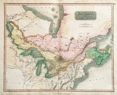
TITLE/CONTENT OF MAP: 'Partie Occidentale du Canada et Septentrionale de la Louisiane avec une Partie de la Pensilvanie par le Sr. d'Anville de l'Academie Rle. des Inscriptions et Belles-Lettres et de celle des Sciences de Petersbourg, Secretaire de S.A.S. Mgr. Le Duc d'Orleans sous le privilege de l'Academie. À Venise par P. Santini 1775 [Western Part of Canada and northern Louisiana with part of Pennsylvania]'
A decorative 18th century map of the Great Lakes of North America, and the upper part of the Mississippi river basin, including much of present day Ontario and the American Mid West
DATE PRINTED: 1784
IMAGE SIZE: Approx 51.5 x 62.0cm, 20.25 x 24.5 inches (Large); Please note that this is a folding map.
TYPE: Large antique 18th century atlas map, printed on thick, good quality paper with original outline hand colour/color and decorative title cartouche
CONDITION: Good; suitable for framing.
VERSO: There is nothing printed on the reverse side, which is plain
FOLDING: This is a folding map.
ARTIST/CARTOGRAPHER/ENGRAVER: Santini, Paolo and d'Anville, Jean Baptiste Bourguignon
PROVENANCE: "Atlas Universel, dressé sur les meilleures cartes modernes", 1784 à Venise par P. Santini, rue Ste Justine, chez M. Remondini
Please note that this lot has a confidential reserve. When you leave a bid in advance of the auction, submit your maximum. The bidder who has submitted the highest bid wins the lot, provided the bid exceeds the reserve price.
Shipping:Domestic: Flat-rate of $25.00 to anywhere within the contiguous U.S. International: Foreign shipping rates are determined by destination. Location: This item ships from United Kingdom
Your purchase is protected:
Photos, descriptions, and estimates were prepared with the utmost care by a fully certified expert and appraiser. All items in this sale are guaranteed authentic.
In the rare event that the item did not conform to the lot description in the sale, Jasper52 specialists are here to help. Buyers may return the item for a full refund provided you notify Jasper52 within 5 days of receiving the item.
A decorative 18th century map of the Great Lakes of North America, and the upper part of the Mississippi river basin, including much of present day Ontario and the American Mid West
DATE PRINTED: 1784
IMAGE SIZE: Approx 51.5 x 62.0cm, 20.25 x 24.5 inches (Large); Please note that this is a folding map.
TYPE: Large antique 18th century atlas map, printed on thick, good quality paper with original outline hand colour/color and decorative title cartouche
CONDITION: Good; suitable for framing.
VERSO: There is nothing printed on the reverse side, which is plain
FOLDING: This is a folding map.
ARTIST/CARTOGRAPHER/ENGRAVER: Santini, Paolo and d'Anville, Jean Baptiste Bourguignon
PROVENANCE: "Atlas Universel, dressé sur les meilleures cartes modernes", 1784 à Venise par P. Santini, rue Ste Justine, chez M. Remondini
Please note that this lot has a confidential reserve. When you leave a bid in advance of the auction, submit your maximum. The bidder who has submitted the highest bid wins the lot, provided the bid exceeds the reserve price.
Shipping:
Your purchase is protected:
Photos, descriptions, and estimates were prepared with the utmost care by a fully certified expert and appraiser. All items in this sale are guaranteed authentic.
In the rare event that the item did not conform to the lot description in the sale, Jasper52 specialists are here to help. Buyers may return the item for a full refund provided you notify Jasper52 within 5 days of receiving the item.
Buyer's Premium
- 15%
Santini/d'Anville: Map of Canada Great Lakes, 1784
Estimate $800 - $1,000
2 bidders are watching this item.
Get approved to bid.
Shipping & Pickup Options
Item located in United Kingdom$25 shipping in the US
Payment
Accepts seamless payments through LiveAuctioneers
See More Items From This Jasper52 Seller

Auction Curated By

Maps Expert
TOP