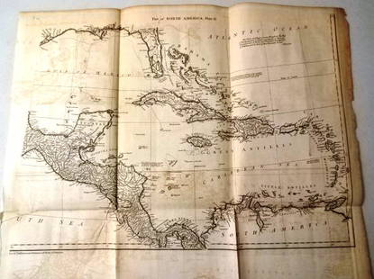
Huge/clean 1867 wall map of North America, J. T. Lloyd
Similar Sale History
View More Items in Maps & AtlasesRelated Maps & Atlases
More Items in Maps & Atlases
View MoreRecommended Transportation & Travel Collectibles
View More


Item Details
Description
Reserve Reduced!
Huge antique wall map in rare condition...varnish appears nearly fresh with absolutely no cracking. Includes original rollers which are also in great condition. Great hand-coloring and strong print. Two-sided wall map. Shows entire breadth of U. S. railway system in 1867. Similar to the 1866 edition but with these changes: (1) adds inset of South America; (2) Pacific Railway route has been changed to go north of Salt Lake; (3) some of the ads on the steamship routes have been deleted, and (4) on the verso in addition to the U.S. map there are insets of major cities and their rail lines. “Lloyd's Topographical Railway Map of North America or the United States Continent in 1900” (On verso: “Lloyd's New Map of the United States The Canadas and New Brunswick From The Latest Surveys Showing Every Railroad & Station Finished to June 1862... 1866”). Shows all major sailing routes including nearly 60 images of ships. Shows railway lines. Idaho, Utah, Wyoming and Dakota borders still not set. "Russian America" for Alaska; "British America" for Canada; "Danish America" for Greenland. Large inset of South America and another inset of The Isthmus of Panama. Title includes the words "In 1900" but Rumsey says this means nothing. Separate hand-colored map also printed on reverse, unvarnished side. Small bit of water damage to extreme top right and right edge with clear tape covering extreme right 2" edge, else near fine. (No damage to map areas) Two nickel-size spots in upper area (top of Canada). Hard to imagine a better copy of this hard-to-find wall map. Extra shipping for large, long package. 56 x 60.
Reserve: $625.00Jasper52 negotiates the lowest reserves so bidders always get the best prices.
Shipping: Domestic: Flat-rate of $15.00 to anywhere within the contiguous U.S. International: Foreign shipping rates are determined by destination. Combined shipping: Please ask about combined shipping for multiple lots before bidding. Location: This item ships from Ohio.
Your purchase is protected:
Photos, descriptions, and estimates were prepared with the utmost care by a fully certified expert and appraiser. All items in this sale are guaranteed authentic.
In the rare event that the item did not conform to the lot description in the sale, Jasper52 specialists are here to help. Buyers may return the item for a full refund provided you notify Jasper52 within 5 days of receiving the item.
Huge antique wall map in rare condition...varnish appears nearly fresh with absolutely no cracking. Includes original rollers which are also in great condition. Great hand-coloring and strong print. Two-sided wall map. Shows entire breadth of U. S. railway system in 1867. Similar to the 1866 edition but with these changes: (1) adds inset of South America; (2) Pacific Railway route has been changed to go north of Salt Lake; (3) some of the ads on the steamship routes have been deleted, and (4) on the verso in addition to the U.S. map there are insets of major cities and their rail lines. “Lloyd's Topographical Railway Map of North America or the United States Continent in 1900” (On verso: “Lloyd's New Map of the United States The Canadas and New Brunswick From The Latest Surveys Showing Every Railroad & Station Finished to June 1862... 1866”). Shows all major sailing routes including nearly 60 images of ships. Shows railway lines. Idaho, Utah, Wyoming and Dakota borders still not set. "Russian America" for Alaska; "British America" for Canada; "Danish America" for Greenland. Large inset of South America and another inset of The Isthmus of Panama. Title includes the words "In 1900" but Rumsey says this means nothing. Separate hand-colored map also printed on reverse, unvarnished side. Small bit of water damage to extreme top right and right edge with clear tape covering extreme right 2" edge, else near fine. (No damage to map areas) Two nickel-size spots in upper area (top of Canada). Hard to imagine a better copy of this hard-to-find wall map. Extra shipping for large, long package. 56 x 60.
Reserve: $625.00
Shipping:
Your purchase is protected:
Photos, descriptions, and estimates were prepared with the utmost care by a fully certified expert and appraiser. All items in this sale are guaranteed authentic.
In the rare event that the item did not conform to the lot description in the sale, Jasper52 specialists are here to help. Buyers may return the item for a full refund provided you notify Jasper52 within 5 days of receiving the item.
Condition
Near fine
Buyer's Premium
- 15%
Huge/clean 1867 wall map of North America, J. T. Lloyd
Estimate $1,100 - $1,300
3 bidders are watching this item.
Get approved to bid.
Shipping & Pickup Options
Item located in Ohio, US$15 shipping in the US
Payment
Accepts seamless payments through LiveAuctioneers
See More Items From This Jasper52 Seller

Auction Curated By

Maps Expert
Related Searches
TOP


![[MAP]. TODESCHI, Pietro. [Nova et Acurata Totius Americae Tabula auct. G.I. Blaeu] America quarta: [MAP]. TODESCHI, Pietro. [Nova et Acurata Totius Americae Tabula auct. G.I. Blaeu] America quarta pars orbis quam plerunq, nuvum orbem appellitant primo detecta est anno 1492 a Christophoro Columbo...](https://p1.liveauctioneers.com/197/329395/177650542_1_x.jpg?height=310&quality=70&version=1715364962)


![[MAP]. ORTELIUS, Abraham. Africae Tabula Nova. 1592.: [MAP]. ORTELIUS, Abraham (1527-1598). Africae Tabula Nova. Antwerp, 1592. Engraved map with hand-coloring. Matted, framed, and double glazed, visible area 406 x 533 mm (unexamined out of frame). Strap](https://p1.liveauctioneers.com/197/329395/177650533_1_x.jpg?height=310&quality=70&version=1715364962)


![[MAPS]. HOMANN, Johann Baptist, HOMANN HEIRS, and Georg Matthäus SEUTTER. [Composite Atlas].: [MAPS]. HOMANN, Johann Baptist (1663-1724), HOMANN HEIRS, and Georg Matthäus SEUTTER (1678-1757). [Composite Atlas]. [Nuremberg, Augsburg, and others: Homann Heirs and others, maps dated between](https://p1.liveauctioneers.com/197/329395/177650530_1_x.jpg?height=310&quality=70&version=1715364962)


