Amérique Septentrionale. British French Spanish North
Similar Sale History
View More Items in Maps & Atlases
Related Maps & Atlases
More Items in Maps & Atlases
View MoreRecommended Transportation & Travel Collectibles
View More


Item Details
Description
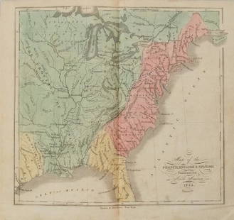
This fabulous map shows North America divided between British (red), French (Green) and Spanish (Yellow) possessions. At this time the British colonies of New England, New York, New Jersey, Pennsylvania, Maryland, Virginia, and Carolina, "Acadie" (Nova Scotia) and Newfoundland occupied a thin sliver along the coast, with the French controlling most of the interior of the continent, including much of present-day eastern Canada. The river systems, notably the Mississippi and Missouri, are well detailed, although the "Grand Riviere" flowing east into Lake Superior through the substantial "Lac des Bois" is a notable inaccuracy. Many towns are marked on the map, especially in the north east, including New York, Boston, Baltimore, Charles Town (Charleston), New Orleans, St Augustine, Philadelphia, Quebec City, Montreal, Havana, Mexico City, Cartagena. Forts, missions and areas occupied by Native American Indian tribes - including "Tecas" (Texas) - are shown. Florida appears rather anorexic and archipelagic compared to its actual shape. In the West Indies, the islands of Grenada and St Lucia are both marked in green as French colonies, as they were at the time - Grenada was ceded to Britain in 1763 and Britain did not regain its previous control of St Lucia until 1803. St Vincent and Dominica are uncoloured. Nassau is coloured red, indicative of a British colony, although the rest of the Bahamas are uncoloured, perhaps reflective of their then status as a haven for pirates
DATE PRINTED: MDCCXLVI (1746). This date is printed on the map
IMAGE SIZE: Approx 90.0 x 87.0cm, 35.25 x 34.25 inches (Large); Please note that this is a folding map.
TYPE: Large antique 18th century atlas wall map, printed on thick, good quality paper with original outline hand colour/color and decorative title cartouche
CONDITION: Very Good; suitable for framing. The map has been printed on four sheets. The upper part of the map comprises two sheets which have been joined. The lower part of the map also comprises two sheets which have been joined. However, the upper and lower parts of the map are unjoined to each other. The map is presented as it will look when joined. The map can be joined prior to shipping/dispatch, or sent unjoined according to the preference of the buyer. We will contact the buyer prior to shipping to ask whether you would like the map to be joined (allow an additional 2 business days) prior to shipping, or sent unjoined. Please check the scan for any blemishes prior to making your purchase. Virtually all antiquarian maps and prints are subject to some normal aging due to use and time which is not obtrusive unless otherwise stated.
VERSO: There is nothing printed on the reverse side, which is plain
FOLDING: This is a folding map.
ARTIST/CARTOGRAPHER/ENGRAVER: Jean Baptiste Bourguignon d'Anville
PROVENANCE: The map was extracted from a composite atlas of early 18th century maps, the latest of which was dated c1754
Reserve: $1,265.00
Shipping:Domestic: Flat-rate of $25.00 to anywhere within the contiguous U.S. International: Foreign shipping rates are determined by destination. Combined shipping: Please ask about combined shipping for multiple lots before bidding. Location: This item ships from United Kingdom.
Your purchase is protected:
Photos, descriptions, and estimates were prepared with the utmost care by a fully certified expert and appraiser. All items in this sale are guaranteed authentic.
In the rare event that the item did not conform to the lot description in the sale, Jasper52 specialists are here to help. Buyers may return the item for a full refund provided you notify Jasper52 within 5 days of receiving the item.
DATE PRINTED: MDCCXLVI (1746). This date is printed on the map
IMAGE SIZE: Approx 90.0 x 87.0cm, 35.25 x 34.25 inches (Large); Please note that this is a folding map.
TYPE: Large antique 18th century atlas wall map, printed on thick, good quality paper with original outline hand colour/color and decorative title cartouche
CONDITION: Very Good; suitable for framing. The map has been printed on four sheets. The upper part of the map comprises two sheets which have been joined. The lower part of the map also comprises two sheets which have been joined. However, the upper and lower parts of the map are unjoined to each other. The map is presented as it will look when joined. The map can be joined prior to shipping/dispatch, or sent unjoined according to the preference of the buyer. We will contact the buyer prior to shipping to ask whether you would like the map to be joined (allow an additional 2 business days) prior to shipping, or sent unjoined. Please check the scan for any blemishes prior to making your purchase. Virtually all antiquarian maps and prints are subject to some normal aging due to use and time which is not obtrusive unless otherwise stated.
VERSO: There is nothing printed on the reverse side, which is plain
FOLDING: This is a folding map.
ARTIST/CARTOGRAPHER/ENGRAVER: Jean Baptiste Bourguignon d'Anville
PROVENANCE: The map was extracted from a composite atlas of early 18th century maps, the latest of which was dated c1754
Reserve: $1,265.00
Shipping:
Your purchase is protected:
Photos, descriptions, and estimates were prepared with the utmost care by a fully certified expert and appraiser. All items in this sale are guaranteed authentic.
In the rare event that the item did not conform to the lot description in the sale, Jasper52 specialists are here to help. Buyers may return the item for a full refund provided you notify Jasper52 within 5 days of receiving the item.
Buyer's Premium
- 15%
Amérique Septentrionale. British French Spanish North
Estimate $1,500 - $2,000
5 bidders are watching this item.
Shipping & Pickup Options
Item located in United Kingdom$25 shipping in the US
Payment
See More Items From This Jasper52 Seller

Auction Curated By

Maps Expert
Related Searches
TOP


![[MAP] BRITISH / FRENCH SETTLEMENTS NORTH AMERICA: Lodge, John. A MAP OF THE BRITISH AND FRENCH SETTLEMENTS IN NORTH AMERICA. London: circa 1750s. Handcoloured. Floral cartouche. The present example includes text detail on the English settlement claim](https://p1.liveauctioneers.com/8124/310027/165853621_1_x.jpg?height=310&quality=70&version=1700184289)


![MAPS - Maine. U.S. Gov.: Maine. U.S. Gov., [Lot of 2] Map of the Northern Part of the State of Maine and of the Adjacent British Provinces... [and] Extract from a Map of the British and French Dominions in North America, 1838](https://p1.liveauctioneers.com/6576/142214/71976779_1_x.jpg?height=310&quality=70&version=1557929467)


