


Scarce 1863 U. S. map w/Civil War Arizona
Similar Sale History
View More Items in Maps & Atlases


Related Maps & Atlases
![Large Map of California: Large Map of California With map of Arizona and Nevada [separately] on versos Cartographer: George Franklin Cram Dated: Circa 1900 Type: Color Lithograph Dimensions: 14](https://p1.liveauctioneers.com/5614/330257/178045314_1_x.jpg?height=310&quality=70&version=1716032806)


![Large Map of Alaska: Large Map of Alaska With map of Washington and Oregon [separately] on versos Cartographer: George Franklin Cram Dated: Circa 1900 Type: Color Lithograph Dimensions: 14](https://p1.liveauctioneers.com/5614/330257/178045317_1_x.jpg?height=310&quality=70&version=1716032806)

![Large Map of Texas (Western Part): Large Map of Texas (Western Part) With map of Louisiana and Arkansas [separately] on versos Cartographer: George Franklin Cram Dated: Circa 1900 Type: Color Lithograph Dime](https://p1.liveauctioneers.com/5614/330257/178045313_1_x.jpg?height=310&quality=70&version=1716032806)
![Large Map of Hawaiian Islands & Porto Rico: Large Map of Porto Rico With map of Hawaii - Hawaiian Islands and Samoa [separately] on versos] Cartographer: George Franklin Cram Dated: Circa 1900 Type: Color Lithograph](https://p1.liveauctioneers.com/5614/330257/178045318_1_x.jpg?height=310&quality=70&version=1716032806)
![Large Map of Montana: Large Map of Montana With map of Utah and Wyoming [separately] on versos Cartographer: George Franklin Cram Dated: Circa 1900 Type: Color Lithograph Dimensions: 14 1/2](https://p1.liveauctioneers.com/5614/330257/178045315_1_x.jpg?height=310&quality=70&version=1716032806)
![Large Map of Texas (Eastern Part): Large Map of Texas (Eastern Part) With map of Alabama and Mississippi [separately] on versos Cartographer: George Franklin Cram Dated: Circa 1900 Type: Color Lithograph Dim](https://p1.liveauctioneers.com/5614/330257/178045312_1_x.jpg?height=310&quality=70&version=1716032806)
![Large Map of Kentucky and Tennessee: Large Map of Kentucky and Tennessee With map of North Dakota and South Dakota [separately] on versos Cartographer: George Franklin Cram Dated: Circa 1900 Type: Color Lithograph](https://p1.liveauctioneers.com/5614/330257/178045311_1_x.jpg?height=310&quality=70&version=1716032806)

![Large Map of Michigan and Wisconsin: Large Map of Michigan and Wisconsin With map of Kansas and Nebraska [separately] on versos Cartographer: George Franklin Cram Dated: Circa 1900 Type: Color Lithograph Dimen](https://p1.liveauctioneers.com/5614/330257/178045309_1_x.jpg?height=310&quality=70&version=1716032806)

![1892 Cowles Civil War Map of Battles in Gettysburg, Virginia, W Virginia and Maryland -- Sketch of: Title: 1892 Cowles Civil War Map of Battles in Gettysburg, Virginia, W Virginia and Maryland -- Sketch of the battle of McDowell, VA. [and] Route Map of Gettysburg Campaign Lt-Gen T.J. Jackson [and] S](https://p1.liveauctioneers.com/5584/329422/177662185_1_x.jpg?height=310&quality=70&version=1715717898)
More Items in Maps & Atlases
View More


![[MAP]. TODESCHI, Pietro. [Nova et Acurata Totius Americae Tabula auct. G.I. Blaeu] America quarta: [MAP]. TODESCHI, Pietro. [Nova et Acurata Totius Americae Tabula auct. G.I. Blaeu] America quarta pars orbis quam plerunq, nuvum orbem appellitant primo detecta est anno 1492 a Christophoro Columbo...](https://p1.liveauctioneers.com/197/329395/177650542_1_x.jpg?height=310&quality=70&version=1715364962)


![[MAPS]. HOMANN, Johann Baptist, HOMANN HEIRS, and Georg Matthäus SEUTTER. [Composite Atlas].: [MAPS]. HOMANN, Johann Baptist (1663-1724), HOMANN HEIRS, and Georg Matthäus SEUTTER (1678-1757). [Composite Atlas]. [Nuremberg, Augsburg, and others: Homann Heirs and others, maps dated between](https://p1.liveauctioneers.com/197/329395/177650530_1_x.jpg?height=310&quality=70&version=1715364962)


Recommended Transportation & Travel Collectibles
View More


Item Details
Description
Reserve Reduced!
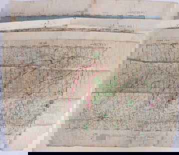
Map of the U. S. showing Arizona in the Civil War configuration designated in 1863. This lasted for only a short time so it’s possible that not very many of this edition were distributed. (The 1864 version shows Arizona in its present-day form.) New Mexico, Nevada, Utah, Nebraska, Dacotah, Washington Territory and Virginia all shown with early borders. Very similar to the 1861 Mitchell U. S. map. With an 1855 copyright but found in Cornell’s 1863 high school geography published by D. Appleton. WorldCat does not show this specific edition. Some spotting, mostly in lower right corner area. Dime-size spot in lower left image area. Minor spotting in lower left margin. Repaired area at top centerfold where paper surface had torn away from main paper area. Short split at bottom centerfold edge. 12.75 x 20.375.
Reserve: $75.00Jasper52 negotiates the lowest reserves so bidders always get the best prices.
Shipping: Domestic: Flat-rate of $8.00 to anywhere within the contiguous U.S. International: Foreign shipping rates are determined by destination. Combined shipping: Please ask about combined shipping for multiple lots before bidding. Location: This item ships from Ohio
Your purchase is protected:
Photos, descriptions, and estimates were prepared with the utmost care by a fully certified expert and appraiser. All items in this sale are guaranteed authentic.
In the rare event that the item did not conform to the lot description in the sale, Jasper52 specialists are here to help. Buyers may return the item for a full refund provided you notify Jasper52 within 5 days of receiving the item.
Map of the U. S. showing Arizona in the Civil War configuration designated in 1863. This lasted for only a short time so it’s possible that not very many of this edition were distributed. (The 1864 version shows Arizona in its present-day form.) New Mexico, Nevada, Utah, Nebraska, Dacotah, Washington Territory and Virginia all shown with early borders. Very similar to the 1861 Mitchell U. S. map. With an 1855 copyright but found in Cornell’s 1863 high school geography published by D. Appleton. WorldCat does not show this specific edition. Some spotting, mostly in lower right corner area. Dime-size spot in lower left image area. Minor spotting in lower left margin. Repaired area at top centerfold where paper surface had torn away from main paper area. Short split at bottom centerfold edge. 12.75 x 20.375.
Reserve: $75.00
Shipping:
Your purchase is protected:
Photos, descriptions, and estimates were prepared with the utmost care by a fully certified expert and appraiser. All items in this sale are guaranteed authentic.
In the rare event that the item did not conform to the lot description in the sale, Jasper52 specialists are here to help. Buyers may return the item for a full refund provided you notify Jasper52 within 5 days of receiving the item.
Condition
Good
Buyer's Premium
- 15%
Scarce 1863 U. S. map w/Civil War Arizona
Estimate $145 - $200
6 bidders are watching this item.
Shipping & Pickup Options
Item located in Ohio, US$8 shipping in the US
Payment
See More Items From This Jasper52 Seller

Related Searches
TOP