


 Weekly: JewelryBonhamsSponsored.Your ad here?
Weekly: Jewelry
Bonhams
Sponsored.Your ad here?


 DesignChristie'sSponsored.Your ad here?
Design
Christie's
Sponsored.Your ad here?


DesignChristie'sSponsored.Your ad here?
Design
Christie's
Sponsored.Your ad here?

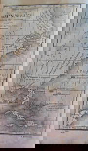
Tourist's Pocket Map of The State of Ohio Exhibiting
Similar Sale History
View More Items in Maps & Atlases


Related Maps & Atlases
![Pocket Map of Richland Co., OH c1910 [180795]: Pocket map - "New Road Map of Richland County, Ohio." Published by The Daily Globe, Shelby, OH, c1910. Map measures 21" x 30". Please see photo(s) for more details. Richland County Ohio](https://p1.liveauctioneers.com/2699/331495/178785767_1_x.jpg?height=310&quality=70&version=1717094933)

![Jacob Monk 1853 Map of North America [173506]: Large wall map, typical nvarnish finish, mounted to board for viewing. "New map of that portion of North America exhibiting the United States and Territories, the Canadas, New Brunswick, Nova Scotia,](https://p1.liveauctioneers.com/2699/331495/178785775_1_x.jpg?height=310&quality=70&version=1717094933)
![Loch Lomond and the Trossachs Tourist Map [Primarily Perthshire]: Publication Date: 1961 Title: Loch Lomond and the Trossachs Tourist Map [Primarily Perthshire] Cartographer: ORDNANCE SURVEY OF GREAT BRITAIN Publisher: ORDNANCE SURVEY Height: 37 Width: 32 Scale one](https://p1.liveauctioneers.com/5584/331064/178466516_1_x.jpg?height=310&quality=70&version=1716924723)


![Early United States Maps, c1800's (2) [180906]: (2) Double Trucked Maps of the United States and North America. Circa 1800's. Map of North America by T. Ettling, railways and projected canals in legend, borders defined in orange ink. Railway Map of](https://p1.liveauctioneers.com/2699/331495/178785772_1_x.jpg?height=310&quality=70&version=1717094933)


More Items in Maps & Atlases
View More
![[MAP]. TODESCHI, Pietro. [Nova et Acurata Totius Americae Tabula auct. G.I. Blaeu] America quarta: [MAP]. TODESCHI, Pietro. [Nova et Acurata Totius Americae Tabula auct. G.I. Blaeu] America quarta pars orbis quam plerunq, nuvum orbem appellitant primo detecta est anno 1492 a Christophoro Columbo...](https://p1.liveauctioneers.com/197/329395/177650542_1_x.jpg?height=310&quality=70&version=1715364962)
![[MAPS]. HOMANN, Johann Baptist, HOMANN HEIRS, and Georg Matthäus SEUTTER. [Composite Atlas].: [MAPS]. HOMANN, Johann Baptist (1663-1724), HOMANN HEIRS, and Georg Matthäus SEUTTER (1678-1757). [Composite Atlas]. [Nuremberg, Augsburg, and others: Homann Heirs and others, maps dated between](https://p1.liveauctioneers.com/197/329395/177650530_1_x.jpg?height=310&quality=70&version=1715364962)


![[MAP]. ORTELIUS, Abraham. Americae Sive Novi Orbis, Nova Descriptio. 1573.: [MAP]. ORTELIUS, Abraham (1527-1598). Americae Sive Novi Orbis, Nova Descriptio. Antwerp, 1573. Engraved map with hand-coloring. Framed and double glazed, visible area 375 x 521 mm (unexamined out of](https://p1.liveauctioneers.com/197/329395/177650534_1_x.jpg?height=310&quality=70&version=1715364962)

![Set of Twelve Satirical Anthropomorphic Maps of Europe: [SATIRICAL MAPS] A set of twelve satirical anthropomorphic maps of Europe. London: circa 1868. A set of 12 (believed complete) lithographed maps by Vincent Brooks, Day & Son, London, each offering](https://p1.liveauctioneers.com/292/330597/178279264_1_x.jpg?height=310&quality=70&version=1716409282)


![[MAP]. ORTELIUS, Abraham. Turcici Imperii Descriptio.1592.: [MAP]. ORTELIUS, Abraham (1527-1598). Turcici Imperii Descriptio. Antwerp, 1592. Engraved map with hand-coloring. Matted, framed, and double glazed, sight 406 x 521 mm (unexamined out of frame). Decor](https://p1.liveauctioneers.com/197/329395/177650538_1_x.jpg?height=310&quality=70&version=1715364962)
![[MAP]. ORTELIUS, Abraham. Romani Imperii Imago. 1592.: [MAP]. ORTELIUS, Abraham (1527-1598). Romani Imperii Imago. Antwerp, 1592. Engraved map with hand-coloring. Matted, framed, and double glazed, visible area 381 x 521 mm (unexamined out of frame). 6 de](https://p1.liveauctioneers.com/197/329395/177650537_1_x.jpg?height=310&quality=70&version=1715364962)
![[MAP]. SPEED, John. A New Mappe of the Romane Empire. 1676.: [MAP]. SPEED, John (ca 1551-1629). A New Mappe of the Romane Empire. London: Basset & Chiswell, 1676. Engraved map with hand-coloring. Framed and double glazed, sight 419 x 559 mm. Decorative cartouch](https://p1.liveauctioneers.com/197/329395/177650541_1_x.jpg?height=310&quality=70&version=1715364962)
Recommended Transportation & Travel Collectibles
View More


Item Details
Description
Finely engraved county map that folded into 16mo dark red roan cover with Mitchell advertising label and 1830 Ohio census pasted inside.Removed and encapsulated, cover preserved.Three small holes at folds causing losses.With two profiles of the Ohio and Erie Canal and Miami Canal along lower margin.Rare.Rare Early Mitchell Pocket Map of Ohio
Reserve: $250.00
Shipping:
Your purchase is protected:
Photos, descriptions, and estimates were prepared with the utmost care by a fully certified expert and appraiser. All items in this sale are guaranteed authentic.
In the rare event that the item did not conform to the lot description in the sale, Jasper52 specialists are here to help. Buyers may return the item for a full refund provided you notify Jasper52 within 5 days of receiving the item.
Condition
Fair
Buyer's Premium
- 15%
Tourist's Pocket Map of The State of Ohio Exhibiting
Estimate $300 - $350
3 bidders are watching this item.
Get approved to bid.
Shipping & Pickup Options
Item located in Tennessee, US$22 shipping in the US
Payment
See More Items From This Jasper52 Seller

Auction Curated By

Maps Expert
Related Searches
TOP