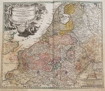
1720 c. Homann Map of Benelux -- Tabula Generalis
Similar Sale History
View More Items in Maps & AtlasesRelated Maps & Atlases
More Items in Maps & Atlases
View MoreRecommended Transportation & Travel Collectibles
View More


Item Details
Description
This is a highly decorative double-page map of the Netherlands, Belgium and Luxembourg with northern France, western Germany and southeast England (including London - Londre) also shown. Other important cities and towns located include Brussel(s), Brugge, Ghent (Gendt), Delft, Amsterdam, Rotterdam, Antwerp(en), Metz, Luxemb(o)urg, Rouen, Amiens, Lille, Calais, Trier, Cologne (Coln), Mainz and Dusseldorf. There is great detail of topography, rivers, marshes, forests, roads, towns, fortified cities, etc. An elaborate cartouche shows the heraldic shields of the 17 provinces as well as Neptune and Hermes with a globe showing the Dutch East Indies.
Reserve: $200.00
Shipping:
Your purchase is protected:
Photos, descriptions, and estimates were prepared with the utmost care by a fully certified expert and appraiser. All items in this sale are guaranteed authentic.
In the rare event that the item did not conform to the lot description in the sale, Jasper52 specialists are here to help. Buyers may return the item for a full refund provided you notify Jasper52 within 5 days of receiving the item.
Condition
Good. Nice strike on thicker laid paper. Slight staining, light edge browning and a few pinholes. Number of city names are underlined post issue. Hand color. Issued centerfold with a split closed on verso. Marginal splits.
Buyer's Premium
- 15%
1720 c. Homann Map of Benelux -- Tabula Generalis
Estimate $300 - $350
3 bidders are watching this item.
Shipping & Pickup Options
Item located in Ohio, US$16 shipping in the US
Payment
See More Items From This Jasper52 Seller

Related Searches
TOP


![1750 Homann Map of French Champaigne Region -- Tabula: Title: 1750 Homann Map of French Champaigne Region -- Tabula Geographica Campaniae Cartographer: J Homann [Family] Year / Place: 1750 c., Nurnberg Map Dimension (in.): 22.3 X 19.1 in. This is a lovely](https://p1.liveauctioneers.com/5584/227445/117579454_1_x.jpg?height=310&quality=70&version=1638310644)


![[MAPS]. HOMANN, Johann Baptist, HOMANN HEIRS, and Georg Matthäus SEUTTER. [Composite Atlas].: [MAPS]. HOMANN, Johann Baptist (1663-1724), HOMANN HEIRS, and Georg Matthäus SEUTTER (1678-1757). [Composite Atlas]. [Nuremberg, Augsburg, and others: Homann Heirs and others, maps dated between](https://p1.liveauctioneers.com/197/329395/177650530_1_x.jpg?height=310&quality=70&version=1715364962)
![HAND COLORED MAP OF PERU & COUNTRY OF THE AMAZONS, 1747, BY EMANUEL BOWEN, FRAMED: A New And Accurate Map Of Peru And The Country Of The Amazones. Drawn From The Most Authentick French Maps &C. And Regulated By Astronomical Observations, London]: William Innys [et al.], 1747. A deta](https://p1.liveauctioneers.com/957/328836/177180798_1_x.jpg?height=310&quality=70&version=1715021458)


![[Maps] Gio. Ant. Magnini, Italia, 1620: [Maps] Gio. Ant. Magnini, Italia, 1620, Giovanni Antonio Magnini. Italia, data in luce da Fabio suo figliuolo al Serenissimo Ferdinado Gonzaga Duca di Matoua edi Monserrato etc. Bologna, for Sebastian](https://p1.liveauctioneers.com/188/326797/176317457_1_x.jpg?height=310&quality=70&version=1713847031)
![[Maps] Martin Zeiler, Itinerarium Italiae, 1640: [Maps] Martin Zeiler, Itinerarium Italiae, 1640, Martini Zeilleri. Itinerarium Italiae Nov-Antiquae: oder, Raiss-Beschreibung durch Italien, Matthaus Merian, Frankfurt, 40 plates, most double-page, in](https://p1.liveauctioneers.com/188/326797/176317459_1_x.jpg?height=310&quality=70&version=1713847031)


![[MAP]. TODESCHI, Pietro. [Nova et Acurata Totius Americae Tabula auct. G.I. Blaeu] America quarta: [MAP]. TODESCHI, Pietro. [Nova et Acurata Totius Americae Tabula auct. G.I. Blaeu] America quarta pars orbis quam plerunq, nuvum orbem appellitant primo detecta est anno 1492 a Christophoro Columbo...](https://p1.liveauctioneers.com/197/329395/177650542_1_x.jpg?height=310&quality=70&version=1715364962)


