D'Anville Map of North America 1746
Similar Sale History
View More Items in Maps & AtlasesRelated Maps & Atlases
More Items in Maps & Atlases
View MoreRecommended Transportation & Travel Collectibles
View More


Item Details
Description
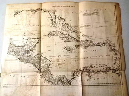
The map of North America and the West Indies was one of the best French maps of North America prior to the French & Indian War. It was made by Jean Baptiste Bourguignon d’Anville (1697 - 1782) in Paris in 1746; d’Anville was the Royal geographer and cartographer to the King of France, a proponent of scientific cartography, and he greatly improved the standards of map-making at the time. He had direct access to many official French records of North America, so his maps are known for their fine detail and clearly presented information. His representation of the Ohio River Valley and the Great Lakes was exceptional, while Georgia seems squeezed in between South Carolina and the Spanish claims to Florida. Texas (Tecas) is named on the map, and many place names, Native Indian tribes, and forts are located on the map as well. There is an inset of Hudson and Baffin Bays in the upper left and a beautiful cartouche drawn by Gravelot on the right side of the map. The map was engraved by Guillaume Delahaye, and the copper-plate engraving is hand-colored. It is a genuine antique map and not a modern copy or reprint. The map has light soiling and measures 21 3/8 x 40 inches wide. The other map shows Central America and the West Indies and was one of the best French maps of Central America prior to the French & Indian War. It was made by Jean Baptiste Bourguignon d’Anville in Paris circa 1746. His representation of Mexico, Cuba, Jamaica, the Florida peninsula, and the lower part of California show fine detail, and many place names and Native Indian tribes are located on the map as well. The map was also engraved by Delahaye, and the engraving is hand-colored. It is a genuine antique map and not a modern copy or reprint, and it is the bottom half of the other map that was done by d’Anville The map has very light soiling on the right side, wear on the left edge, and measures 20 5/8 x 41 inches wide.
Buyer's Premium
- 26%
D'Anville Map of North America 1746
Estimate $600 - $1,200
7 bidders are watching this item.
Shipping & Pickup Options
Item located in SARASOTA, FL, usOffers In-House Shipping
Local Pickup Available
Payment

Related Searches
TOP


![A desirable early issue of Hondius map of Virginia and Florida: [MAP-NORTH AMERICA] MERCATOR, GERARD and HONDIUS, JOCODUS. Virginiae item et Floridae Americae Provinciarum, nova descriptio. [Amsterdam: Jodocus Hondius, 1607 or later]. Hand-colored engraved map. Wi](https://p1.liveauctioneers.com/292/326828/175962855_1_x.jpg?height=310&quality=70&version=1713473479)
![A highly detailed map of New England after the Jansson-Visscher series: [MAP-NORTH AMERICA] [MONTANUS, ARNOLDUS]. Novi Belgii Quod nune Novi Jorck vocatur, Novae Angliae & Partis](https://p1.liveauctioneers.com/292/326828/175962858_1_x.jpg?height=310&quality=70&version=1713473479)
![Homann's expansive map of North America: [MAP-NORTH AMERICA] HOMANN, JOHANN BAPTISTA.Regni Mexicani seu Novae Hispaniae Ludov](https://p1.liveauctioneers.com/292/326828/175962859_1_x.jpg?height=310&quality=70&version=1713473479)
![Jansson's important early map of New England: [MAP-NORTH AMERICA] JANSSON, JAN. Nova Belgica et Anglia Nova. Amsterdam: circa 1646. Latin text on verso. Neat lines 15 1/4 x 19 3/4 inches (38.7 x 50.5 cm). Marginal tears r](https://p1.liveauctioneers.com/292/326828/175962856_1_x.jpg?height=310&quality=70&version=1713473479)
![After De L'Ise's map of North America: [MAP-NORTH AMERICA] DE L'ISLE, GUILLAUME, after. L'Amerique Septentrionale Dressee sur les Observations de Mrs de l'Academie Royale des Sciences. Amsterdam: R.& J. Ottens, circa 1730 or later. Han](https://p1.liveauctioneers.com/292/326828/175962860_1_x.jpg?height=310&quality=70&version=1713473479)
![A marked improvement on the Hondius map of 1606 (Burden): [MAP-NORTH AMERICA] [JANSSON, JAN]. Virginiae partis australis et Floridae partis orientalis, interjacentiumq, regionum Nova Descriptio. Amsterdam: Blaeu, circa 1640. Second state (left cherub with ta](https://p1.liveauctioneers.com/292/326828/175962857_1_x.jpg?height=310&quality=70&version=1713473479)


![The top sheet of the famous Ratzer Map - with additions relating to an 1810 real estate dispute: RATZER, BERNARD. Plan of the City of New York, in North America surveyed in the Years 1766 & 1767. [London: Jefferys & Faden, 12 January 1776.] Engraved map with hand coloring and manuscript a](https://p1.liveauctioneers.com/292/326828/175962862_1_x.jpg?height=310&quality=70&version=1713473479)


