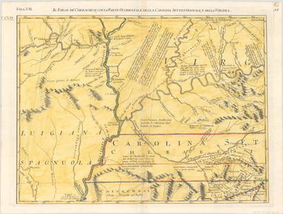
1639 Jansson Map of US Southeast from Virginia
Similar Sale History
View More Items in Maps & Atlases
Related Maps & Atlases
More Items in Maps & Atlases
View MoreRecommended Transportation & Travel Collectibles
View More


Item Details
Description
This is a magnificent map of the US Southeast, extending from the southern part of Chesapeake Bay to northern Florida. The map presents the English and French colonial interests in the region as depicted by their respective royal arms. At the southern end of the Appalachians is a note concerning gold and silver mines. The Chesapeake Bay correctly indicated as a large bay and the Carolinas and Georgian coasts depicted more accurately than earlier maps. On this map a number of settlements are named, including Jamestown (est. 1609) and Newport News (est. 1621). It includes mythical lakes in the interior and other conjectural cartography of the time. This Jansson map is virtually identical to Blaeu's map (A key difference being is by the erroneous longitudinal number 200 in the lower right corner on Blaeu's map vs. the correct number, 300, appearing on Jansson's map such as this.) There is a richly decorated large cartouche flanked by Native Americans. The Atlantic Ocean contains two compass roses, three sailing ships and two aquatic putti. French text on verso, published between 1652-58.
Reserve: $700.00
Shipping:
Your purchase is protected:
Photos, descriptions, and estimates were prepared with the utmost care by a fully certified expert and appraiser. All items in this sale are guaranteed authentic.
In the rare event that the item did not conform to the lot description in the sale, Jasper52 specialists are here to help. Buyers may return the item for a full refund provided you notify Jasper52 within 5 days of receiving the item.
Condition
Very Good, Clean strike on laid paper. A few spots. A few small marginal splits, one restored on verso. Issued centerfold, with small split. Hand colored.
Buyer's Premium
- 15%
1639 Jansson Map of US Southeast from Virginia
Estimate $800 - $1,000
3 bidders are watching this item.
Shipping & Pickup Options
Item located in Ohio, US$20 shipping in the US
Payment
See More Items From This Jasper52 Seller

Auction Curated By

Maps Expert
Related Searches
TOP


![1893 Civil War Map of Washington and NE. Virginia -- Surveys for Military Defenses Map of: Title: 1893 Civil War Map of Washington and NE. Virginia -- Surveys for Military Defenses Map of Northeastern Virginia and Vicinity of Washington [Sheet 1 Plate VII] Cartographer: US War Department Ye](https://p1.liveauctioneers.com/5584/241996/125442504_1_x.jpg?height=310&quality=70&version=1648585952)
![1893 Civil War Map of Northern Virginia -- Sheet 2. Survey for Military Defenses Map of Northeastern: Title: 1893 Civil War Map of Northern Virginia -- Sheet 2. Survey for Military Defenses Map of Northeastern Virginia and Vicinity of Washington [Plate VII] Cartographer: US War Department Year / Place](https://p1.liveauctioneers.com/5584/270923/141842311_1_x.jpg?height=310&quality=70&version=1670433092)


![[Maps] Martin Zeiler, Itinerarium Italiae, 1640: [Maps] Martin Zeiler, Itinerarium Italiae, 1640, Martini Zeilleri. Itinerarium Italiae Nov-Antiquae: oder, Raiss-Beschreibung durch Italien, Matthaus Merian, Frankfurt, 40 plates, most double-page, in](https://p1.liveauctioneers.com/188/326797/176317459_1_x.jpg?height=310&quality=70&version=1713847031)


![[Maps] Gio. Ant. Magnini, Italia, 1620: [Maps] Gio. Ant. Magnini, Italia, 1620, Giovanni Antonio Magnini. Italia, data in luce da Fabio suo figliuolo al Serenissimo Ferdinado Gonzaga Duca di Matoua edi Monserrato etc. Bologna, for Sebastian](https://p1.liveauctioneers.com/188/326797/176317457_1_x.jpg?height=310&quality=70&version=1713847031)


