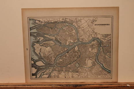
Sold20191888 Cram Map of St. Petersburg [verso] Stocholm --St.Title/Content of Map: 1888 Cram Map of St. Petersburg [verso] Stocholm --St. Petersburg (Russia) [verso] Stockholm Date: 1888, Chicago Cartographer: G CramSize: 9.2 X 11.8 in. This is a very nice andSee Sold Price
Sold20201890 Map of St. PetersburgAuthor: Cram Title: 1890 Map of St. Petersburg Medium: Ink on Paper Dimensions: 13.5"X11" Map of St. Petersburg dated 189o. Engraved and published by George Cram in Chicago. Very detailed. Key lower rSee Sold Price
Sold2017Maps of St. Petersburg & Edinburgh, 1895Map: 1895 Maps of St. Petersburg and Edinburgh -- St. Petersburg (Russia) [verso] Edinburgh Scotland Year / Place: 1895 Map Dimensions: 9.3 x 12 in. Condition: Very good. Nicely colored. Age toning, mSee Sold Price
Sold20211900 St. Petersburg MapAuthor: Cram Title: 1900 St. Petersburg Map Medium: Ink on Paper Dimenions: 14.5"X11" Description: Map of St. Petersburg dated 1900. Printed and published by George Cram in Chicago. Part of his WorldSee Sold Price
Sold20175 Roubles 1888 (??), St. Petersburg, GOLD (6.46 g)Mint luster. Bitkin 27 XF+ 1254 xxvSee Sold Price
Sold2024MAP, St. Petersburg, Daumont Co.St. Petersburg, Russia. Daumont Company, Area Magna Petropolitana / La Grande Place de Petersbourg, 1780 (circa). Hand Color. This striking view depicts a vast street or courtyard in St. Petersburg. VSee Sold Price
Sold2018V. STRAVINSKY (1888-1982) Russian - French - AmericanVera STRAVINSKY (1888 St.Petersburg, Russia - 1982 New York, USA) ; Abstract ; mid 20th century ; oil on canvas / framed ; dimensions 61 x 92 cm (24 x 36 1/4 in.) ; signed lower right corner ; ShippinSee Sold Price
Sold2018SDUK: Antique Map of St Petersburg, 1847TITLE/CONTENT OF MAP: 'ST PETERSBURG' DATE PRINTED: 1847 IMAGE SIZE: Approx 34.0 x 40.0cm, 13.25 x 15.75 inches (Large) TYPE: Antique steel engraved map with original outline hand colouring. Inset: PaSee Sold Price
Sold2019Five Russian silver spoonsThe back of bowls engraved with initials and dated 1888. St Petersburg, 1888. Assay master Mikail Karpinshie. 103g. L. 14 cm (5 1/2 in.)See Sold Price
Sold2017SDUK, Map of St Petersburg, 1834Map: Saint Petersburg Maker: Society for the Diffusion of Useful Knowledge (SDUK) Date: 1834 Medium: Engraving Size: 12.75 x 15.25 inches A detailed plan of St Petersburg in 1834 naming most streets aSee Sold Price
Sold2017SDUK: Map of St. Petersburg, 1834St. Petersburg. The meticulously detailed Society for the Diffusion of Useful Knowledge plan of St. Petersburg, Russia, is centered on the Peter and Paul Fortress, with major thoroughfares and publicSee Sold Price
Sold2018Map of St. Petersburg (Petrograd) Reproduction -- PlanyReserve Reduced! Title/Content of Map:Map of St. Petersburg (Petrograd) Reproduction -- Plany Goroda S. Peterburga… [in cyrillic] Date:1894 map - 20th century reprint Cartographer:I Schelanskago SizSee Sold Price
Sold2023Vintage Hand Colored Map of St. PetersburgVintage hand colored map of St. Petersburg. [Map: 13" H x 15" W; Frame: 18" H x 21" W]. Foxing.See Sold Price
Sold2023RUSSIAN OIL PAINTING DOGS BY IVAN POCHITONOV 1915A lot of three oil on board sketches by Ivan Pavlovich Pokhitonov, Russian, 1850 to 1923. All three sketches are probably representing Krotkiy, the artist's dog. Inscribed verso: St. Petersburg, 1915.See Sold Price
Sold2017MIKHAIL MARKELOVITCH GUZHAVIN 1888 Guzhavino - St.MIKHAIL MARKELOVITCH GUZHAVIN 1888 Guzhavino - St. Petersburg 1931 (attr.) Before the thunderstorm Oil on canvas, 50,5 by 70 cm, lower right in cyrillic marked 'M. Guzhavin', partially damaged and resSee Sold Price
Sold2019Ca.1869 Keith Johnston St. Petersburg MapCirca 1869 S. Petersburg Map and its Environs by Keith Johnston. Printed by William Blackwood and Sons, Edinburgh and London. Measures 19.375 in. x 24.5 in. Unframed, loose and not mounted or glued doSee Sold Price
Sold2018A Large Russian Silver Tankard* A Large Russian Silver Tankard Johan Olsonius for Grachev, Assay of Aleksandr Frans Van Der Vliet, St. Petersburg, 1888 the hipped baluster form body engraved with foliate bands, raised on a steppedSee Sold Price
Sold201519th c. Russian silver soup ladle & child's cup1) Russian silver soup ladle, St. Petersburg, 1894, monogrammed, 2) Russian silver child's cup, firm of Grachev, St. Petersburg, 1888See Sold Price
Sold20191876 Mitchell Chicago [verso] St. Louis -- ChicagoTitle/Content of Map: 1876 Mitchell Chicago [verso] St. Louis -- Chicago [verso] St. Louis Date: 1876 Philadelphia Cartographer: S Mitchell Size: 13.8 X 10.8 in. Two nice Midwest City Maps of ChicagoSee Sold Price
Sold2018Sidney Hall: Antique Map Cronstadt & Kotlin Island 1856Title/Content of Map: 'Cronstadt [inset: Environs of St Petersburg]' Kotlin Island Peterhof Date Printed: 1856 Image Size: Approx 27.0 x 22.5cm, 10.75 x 8.75 inches (Medium) Type: Antique atlas map CoSee Sold Price
Sold2022Antique Map - Map of Europe - Russia / Ukraine - Moscow, St. Petersburg, PoltavaAntique map of Russia by Becker, published in London, c 1843. This antique map was engraved by the omnigraph method by Francis Paul Becker & Company, Patentees circa 1842, with contemporary hand colouSee Sold Price
Sold20241794 Map Of The Asiatic Part Of The Russian EmpireThe Asiatic Part of the Russian Empire, from the maps published by the Imperial Academy of St. Petersburg with the new discoveries of Captn. Cook &cSee Sold Price
Sold2022(TRAVEL -- ASIA.) John Bell. Travels From St. Petersburg in Russia to Diverse Parts of Asia.(TRAVEL -- ASIA.) John Bell. Travels From St. Petersburg in Russia to Diverse Parts of Asia. Engraved folding map showing the route from Moscow to Beijing with a decorative inset of the Chinese capitaSee Sold Price
Sold2019BALTIC SEA Kronstadt St Petersburg Turku TallinnTITLE/CONTENT OF MAP: 'Baltic Sea' This map is folding hence the centrefold line may show on the image below DATE PRINTED: 1860 IMAGE SIZE: Approx 35.5 x 27.0cm, 14 x 10.5 inches (Large); Please noteSee Sold Price
Jun 07Freeman's | Hindman[MAP]. ORTELIUS, Abraham. Peregrinationis Divi Pauli Typus Corographicus. 1592.$150(1 bid)


![1888 Cram Map of St. Petersburg [verso] Stocholm --St.: Title/Content of Map: 1888 Cram Map of St. Petersburg [verso] Stocholm --St. Petersburg (Russia) [verso] Stockholm Date: 1888, Chicago Cartographer: G CramSize: 9.2 X 11.8 in. This is a very nice and](https://p1.liveauctioneers.com/5584/137769/69881360_1_x.jpg?height=310&quality=70&version=1552435690)
![1888 Cram Map of St. Petersburg [verso] Stocholm --St. First Image](https://p1.liveauctioneers.com/5584/137769/69881360_1_x.jpg?height=300&quality=1&version=1552435690&width=300)
![1888 Cram Map of St. Petersburg [verso] Stocholm --St. First Image](https://p1.liveauctioneers.com/5584/137769/69881360_1_x.jpg?height=300&quality=95&version=1552435690&width=300)
![Maps of St. Petersburg & Edinburgh, 1895: Map: 1895 Maps of St. Petersburg and Edinburgh -- St. Petersburg (Russia) [verso] Edinburgh Scotland Year / Place: 1895 Map Dimensions: 9.3 x 12 in. Condition: Very good. Nicely colored. Age toning, m](https://p1.liveauctioneers.com/5584/105887/54238253_1_x.jpg?height=310&quality=70&version=1498761257)


![Map of St. Petersburg (Petrograd) Reproduction -- Plany: Reserve Reduced! Title/Content of Map:Map of St. Petersburg (Petrograd) Reproduction -- Plany Goroda S. Peterburga… [in cyrillic] Date:1894 map - 20th century reprint Cartographer:I Schelanskago Siz](https://p1.liveauctioneers.com/5584/130954/66567858_1_x.jpg?height=310&quality=70&version=1542157455)
![Vintage Hand Colored Map of St. Petersburg: Vintage hand colored map of St. Petersburg. [Map: 13" H x 15" W; Frame: 18" H x 21" W]. Foxing.](https://p1.liveauctioneers.com/1221/275442/145469144_1_x.jpg?height=310&quality=70&version=1675222498)


![1876 Mitchell Chicago [verso] St. Louis -- Chicago: Title/Content of Map: 1876 Mitchell Chicago [verso] St. Louis -- Chicago [verso] St. Louis Date: 1876 Philadelphia Cartographer: S Mitchell Size: 13.8 X 10.8 in. Two nice Midwest City Maps of Chicago](https://p1.liveauctioneers.com/5584/138633/70306036_1_x.jpg?height=310&quality=70&version=1553637454)
![Sidney Hall: Antique Map Cronstadt & Kotlin Island 1856: Title/Content of Map: 'Cronstadt [inset: Environs of St Petersburg]' Kotlin Island Peterhof Date Printed: 1856 Image Size: Approx 27.0 x 22.5cm, 10.75 x 8.75 inches (Medium) Type: Antique atlas map Co](https://p1.liveauctioneers.com/5584/115413/59308629_1_x.jpg?height=310&quality=70&version=1516757305)


![[MAP]. ORTELIUS, Abraham. Peregrinationis Divi Pauli Typus Corographicus. 1592. (1 of 2)](https://p1.liveauctioneers.com/197/329395/177650535_1_x.jpg?height=282&quality=70&version=1715364962)


