Sold20211994 Texas Base Elevation MapVintage Texas base elevation map, dated 1994, Hubbard Scientific, framed frame: 26.5"h x 28"w Provenance: The James Turnbow Estate (Beeville, Texas) We happily provide seamless shipping services onSee Sold Price
Sold2022CHARLES UMLAUF (1911-1994) BRONZE FEMALE TORSOGilt bronze sculpture, Female Torso, signed in the cast C. Umlauf (Charles Umlauf, Michigan, Texas, 1911-1994), on black stone base, bronze: 14.25"h, overall: approx 15.5"h, 10"w, 7"d, 18lbs **ProvenaSee Sold Price
Sold2022CHARLES UMLAUF (1911-1994) ONYX FEMALE TORSOCarved onyx sculpture, Female Torso, on granite base, signed C. Umlauf (Charles Umlauf, Michigan, Texas, 1911-1994), overall: approx 14"h, 7"w, 8.5"d, 21lbs **Provenance: A prominent Austin estate** SSee Sold Price
Sold2019Charles Umlauf (American/Texas, 1911-1994)Charles Umlauf (American/Texas, 1911-1994) "The Three Graces" patinated bronze bas-relief plaque set within an integral marble stand/base, cast signature and foundry mark at lower right of plaque. h.See Sold Price
Sold2021Charles Umlauf (1911-1994), "Baby"Charles Umlauf (1911-1994), "Baby", bronze on marble base, 22 x 9 x 10", with book, "The Sculpture and Drawing of Charles Umlauf", 1980, University of Texas Press Provenance: An Austin, Texas estateSee Sold Price
Sold2023Frederick Hart, "The Awakening of Eve", 1994Frederick Elliott Hart (Amer., 1943-1999), "The Awakening of Eve", 1994, bronze sculpture on black granite base, ed. 170/350 height 19.5 in. x width 15 in. x depth 5.25 in. Provenance: A DalSee Sold Price
Sold2021ROBERT DELFORD BROWN (American/Texas 1930-2009) A MIXEDROBERT DELFORD BROWN (American/Texas 1930-2009) A MIXED MEDIA COLLAGE, "Another Map to Nevada, San Antonio," 1994, mixed media collage on paper, mounted to board, signed and dated along right edge. 18See Sold Price
Sold20162 Texas Maps inc. Greenleaf, Tallis1st item: Jeremiah Greenleaf, "Texas Compiled from the Latest and Best Authorities," from a rare 1848 reissue of Greenleaf’s 1842 Universal Atlas. Greenleaf's 1842 map of Texas was based upon Burr��See Sold Price
Sold2023SOCIETY FOR DIFFUSION OF USEFUL KNOWLEDGE, A REPUBLIC OF TEXAS MAP, "Central America II. IncludingSOCIETY FOR DIFFUSION OF USEFUL KNOWLEDGE, A REPUBLIC OF TEXAS MAP, "Central America II. Including Texas, California and the Northern States of Mexico," LONDON, CIRCA 1842, lithograph on paper, publisSee Sold Price
Sold2023CARL FLEMMING (c. 1840-1879) A REPUBLIC OF TEXAS MAP, "Mexico, Mittel America, Texas," GLOGAU, CIRCACARL FLEMMING (c. 1840-1879) A REPUBLIC OF TEXAS MAP, "Mexico, Mittel America, Texas," GLOGAU, CIRCA 1846, a German lithograph on paper with hand color showing territories claimed by the Republic of TSee Sold Price
Sold2023Texas Map ( Civil War)Texas Map ( Civil War) Texas As She Originally Was - As She Claimed To Be And As She Actually was at The Date of her Annexation. Rare. Print Type: Engraving Date: 1864</See Sold Price
Sold2021A REPUBLIC OF TEXAS MAP, "Méxique," THUNOT DUVOTENAY,A REPUBLIC OF TEXAS MAP, "Méxique," THUNOT DUVOTENAY, PARIS, CIRCA 1843, hand-colored lithograph on paper, Thunot Duvotenay, French cartographer, Charles Smith, English plate engraver, a page fragmeSee Sold Price
Sold20191887 Page Co. Map of Texas -- Map of TexasReserve Reduced! Title/Content of Map: 1887 Page Co. Map of Texas -- Map of Texas Date: 1887 Chicago Cartographer: H. R. Page & Co. Size: 26 X 16.5 in. This large Texas map is a rare issue by the littSee Sold Price
Sold20171855 1st Ed. Texas map from Colton’s Atlas of the WorldItem: 1855 1st Ed. Texas map from Colton’s Atlas of the World Description: Counties current to 1854 making this the uncommon and desirable first edition (Tarrant county appears, but not the 1855 addSee Sold Price
Sold2021A REPUBLIC OF TEXAS MAP, "Amérique Septentrionale,"A REPUBLIC OF TEXAS MAP, "Amérique Septentrionale," EARLY 20TH CENTURY, hand-colored lithograph on paper, after geographical works by Malte-Brun, Thierry et Barthelmier, engravers, J. Blumenthal,See Sold Price
Sold20231890'S TEXAS MAP PRINTED IN 19021890'S TEXAS MAP PRINTED IN 1902. Height: 22.75 in. by Width: 29.75 in. by Depth: 1See Sold Price
Sold2021Scarce 1853 Texas map by Roswell SmithAntique and hard to find antebellum map with full original hand coloring. Engraving on paper. Shows forts, rivers, locations of tribes, towns, counties and topographical features. Eastern Indian TerriSee Sold Price
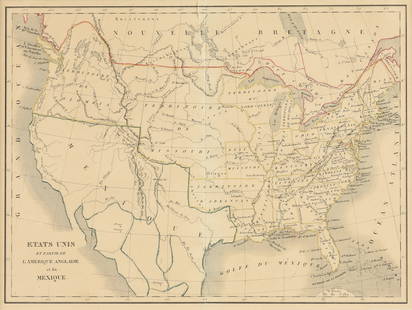
Sold2023EUSTACHE-HYACINTHE LANGLOIS (1777-1837) A MEXICAN TEXAS MAP, "Etats Unis et Partie de L'AméEUSTACHE-HYACINTHE LANGLOIS (1777-1837) A MEXICAN TEXAS MAP, "Etats Unis et Partie de L'Amérique Anglaise et du Mexique," PARIS, CIRCA 1830, lithograph on cream wove paper with hand color, probabSee Sold Price
Sold2021Vintage Texas MapVintage map of Texas, framed frame: 17 x 19" Condition: Foxing Provenance: The collection of former CIA Director R. James Woosley & Nancye Miller (San Antonio, Texas) We happily provide seamleSee Sold Price
Sold2024INCREDIBLE 4 11/16" TEXAS BASE TANG KNIFE, ROGERS COA, FOUND IN CENTRAL TEXAS, VERY LARGE NO BRAINERINCREDIBLE 4 11/16" TEXAS BASE TANG KNIFE, ROGERS COA, FOUND IN CENTRAL TEXAS, VERY LARGE NO BRAINER OLD EXAMPLESee Sold Price
Sold2022A REPUBLIC OF TEXAS MAP, "North America," CHAPMAN & HALL, BRITISH, 1843,A REPUBLIC OF TEXAS MAP, "North America," CHAPMAN & HALL, BRITISH, 1843, hand colored engraving on paper, Published by Chapman & Hall...under the Superintendence of the Society for the Diffusion of UsSee Sold Price
Sold2022Scarce Texas map (eastern part) from Asher & Adams,County map of Eastern Texas extends from Louisiana west to beyond San Antonio and features the railroad system of that time. Features numerous railroads still in their infancy, along with proposed futSee Sold Price
Sold2022Scarce Texas map (western part) from Asher & AdamsLarge double-page map of Western Portion of Texas with inset of extreme western tip of the state. Shows towns, proposed railroad lines and river, including the Colorado River and the Rio Grande. The fSee Sold Price
Jun 09Austin Auction GalleryCHARLES UMLAUF (1911-1994) FEMALE BATHER TORSO MARBLE SCULPTURE$2,000(1 bid)
6 days LeftAntiques Online AuctionsVintage Texas 1845 Map Printed in 1986, Compiled by John Davis$60(4 bids)
Jun 23Schilb Antiquarian Rare Books1848 Emory Military Reconnaissance 1ed California MAP Indians Texas New Mexico$2(2 bids)
Jun 06Akiba GalleriesAntique Mast, Crowell, & Kirkpatrick Map Of Texas, California, & Nevada$25(1 bid)