Sold2021Vintage Texas MapVintage map of Texas, framed frame: 17 x 19" Condition: Foxing Provenance: The collection of former CIA Director R. James Woosley & Nancye Miller (San Antonio, Texas) We happily provide seamleSee Sold Price
Sold2023Collection of Vintage Texas Maps & SurveysLarge collection of miscellaneous maps and surveys, largely relating to Texas, to include some oil examples We happily provide seamless shipping services on everything we sell. Please email us at shiSee Sold Price
Sold2024Vintage Texas 1845 Map Printed in 1986, Compiled by John DavisVintage Texas 1845 Map Printed in 1986, Compiled by John Davis and signed by him on 1992. 32 1/4 x 26 1/4 x 3/4 in.Local Pick up call one day before to make an appointment. TO SHIP THIS ITEM IN USA ORSee Sold Price
Sold2019AN VINTAGE MAP, "Texas and Indian Territory," SECONDAN VINTAGE MAP, "Texas and Indian Territory," SECOND QUARTER 20TH CENTURY, color engraving on paper, showing counties, cities, rail lines, and rivers. 13.25" x 10.125"See Sold Price
Sold20211994 Texas Base Elevation MapVintage Texas base elevation map, dated 1994, Hubbard Scientific, framed frame: 26.5"h x 28"w Provenance: The James Turnbow Estate (Beeville, Texas) We happily provide seamless shipping services onSee Sold Price
Sold20231866 Schönberg's Early Map of Texas Historic Vintage Inspired Map1866 Schönberg's Early Map of Texas Historic Vintage Inspired Map As settlers spread west, Schönberg's map of Texas shows the growing state of Texas and the contemporary counties as ofSee Sold Price
Sold20221866 Schönberg's Early Map of Texas Historic Vintage Inspired Map1866 Schönberg's Early Map of Texas Historic Vintage Inspired Map As settlers spread west, Schönberg's map of Texas shows the growing state of Texas and the contemporary counties as ofSee Sold Price
Sold2022Vintage County Maps of Texas Topography Maps TexasThese are vintage maps that were first made in 1915 and 1921. These maps are a great glance into the early official mapping of the Americas. The two maps in this lot are of Texas. (1) Topography map oSee Sold Price
Sold2022Vintage Maps of Texas CountiesBound vintage book containing maps of Texas counties, featuring maps based off early twentieth century cartography 1.5"h x 17"w x 14"d We happily provide seamless shipping services on everything weSee Sold Price
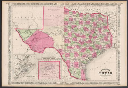
Sold2023Excellent example of Johnson’s Texas, 1866Authentic and impressive vintage map of Texas. One of the more collectible maps to be produced in the mid-19th century. A highly desirable map that details the state in full. Shows the elevated TableSee Sold Price
Sold2021Scarce Colton 2-page map of Texas, c1884Breathtakingly large, fully hand-colored vintage map of Texas from the very scarce 1890 edition of Colton’s General Atlas. This is the only edition of this atlas that I’ve ever seen—See Sold Price
Sold2022Exceptional map of Johnson's Texas, 1866Authentic and impressive vintage map of Texas. A highly desirable map that details the state in full. Shows the elevated Table Lands, the U. S. Mail Route, the Staked Plain (El Llando Estadado), numerSee Sold Price
Sold2021Smille, "Military Plaza - San Antonio, Texas†and MapJames Smille and Arthur Schott, titled "Military Plaza - San Antonio Texas”, engraving, to also include a vintage map of Texas, framed frame: 13.5"h x 17"w/ largest Provenance: A San Antonio, TXSee Sold Price
Sold2021Set 8 of School Charts - Texas History and ResourcesSet 8 of Vintage School Charts Maps - Texas History and Resources36 in tall x 45 x 1 - Denoyer - Geppert of Chicago / J. L Clark & Lewis W. NewtonSee Sold Price
Sold20221846 Vintage New Map of Texas Oregon and California1846 A New Map of Texas Oregon and California A New Map of Texas Oregon and California With The Regions Adjoining. Compiled from the most recent authorities. Philadelphia Published by S. Augustus MitSee Sold Price
Sold2021Early U.S. map shows Texas, Upper Calif. – 1839Title: Early U.S. map shows Texas, Upper Calif. – 1839 Description: Vintage and interesting geography map showing Texas and Upper California at a time when they made up the entire southwestern UniteSee Sold Price
Sold2024E.O. Goldbeck (1892-1986), Texas Oil Field PhotoVintage pictorial map of oilfields of Burkburnett, Texas, dated April 15th, 1919, marked #2, photographed by Charles Steele, framed sight: 8.5 x 60.5 in., frame: 13.5 x 65.5 in. Provenance: PropertySee Sold Price
Sold2021San Antonio Conservation Society 1926 MapVintage 1926 San Antonio Conservation Society historic guide map of San Antonio de Bexar, drawn by Emily Edwards, portrays San Antonio from 1682-1721, unframed 39 x 28"; Provenance: A Schertz, TX EsSee Sold Price
Sold2022San Antonio Conservation Society 1926 MapVintage 1926 San Antonio Conservation Society historic guide map of San Antonio de Bexar, drawn by Emily Edwards, portrays San Antonio from 1685-1721, framed, dated 1926 41"h x 30"w Provenance: A SSee Sold Price
Sold2023Framed Map of Fort Worth StockyardsVintage map of the U.S. Department of Agriculture's 1937 master plan for the Fort Worth Stockyards, framed sight: 22 x 30 in., frame: 33 x 45 in. Provenance: The Dallas, Texas collection of a lSee Sold Price
Sold2022Hamilton MFG Map CabinetVintage wooden map cabinet, marked Hamilton MFG (Two Rivers, Wisconsin), featuring ten drawers with metal pulls 21"h x 25.5"d Provenance: A New Braunfels, Texas Collection We happily providSee Sold Price
Sold2023Vintage Wooden Vertical Map CaseVintage wooden map case, vertical orientation, hinged lid opens to fitted interior height 57 in. x width 29 in. x depth 14 in. We happily provide seamless shipping services on everything we sell. PlSee Sold Price
Sold2021Vintage Atlas School Map CabinetVintage Atlas School map cabinet, to include vintage world maps in wooden display case 19"h x 53.5"w x 4"d Provenance: The Estate of Barbara "Babs" Baugh (San Antonio, Texas) WeSee Sold Price
Jun 20The Ross Art GroupOriginal Air France Planisphere Brown Vintage Map by Lucien Boucher 1948$1,200
6 days LeftJasper52Africae / Africa by Bertius / Langenes 1603 old antique vintage map plan chart$260
6 days LeftJasper52Port di Napoli. Naples, Italy. ADMIRALTY sea chart 1937 (1955) old vintage map$280
Featured6 days LeftJasper52THE PORT OF LONDON showing wharves & docks. Thames. Vintage map. BACON 1919$480
6 days LeftMynt AuctionsVintage Texas Longhorns 1958 Sugar Bowl Pennant 30x12 Inch Very Rare 52336$10
Featured5 days LeftJasper521775-1780. New York, New Jersey, Pennsylvania, Maryland, Virginia and New England states. By Bonne &$120