Sold2023C. 1779, ANTARCTICA & CAPTAIN COOK'S TRAVELS MAPAntonio Zatta (Italian fl. 1775-1797), "Emisfero Terrestre Meridionale Tagliato su l'Equatore", circa 1779, hand colored etching on paper depicting map of Antarctica and Captain Cook's travels, unframSee Sold Price
Sold2022c. 1781 Captain Cook Voyages Map, London by Alexander HoggHistoric Maps "A Plan of Success Bay in Strait Le Maire / A Chart of the S.E. part of Terra del Fuego... by Captn. Cook 1769" c. 1781, A "Dual" Map from Captain Cook's Voyages, titled: "A Plan of SuccSee Sold Price
Sold2022c. 1781 Captain Cook Voyages Map, London by Alexander HoggHistoric Maps "A Plan of Success Bay in Strait Le Maire / A Chart of the S.E. part of Terra del Fuego... by Captn. Cook 1769" c. 1781, Dual Map from Captain Cook's Voyages, titled: "A Plan of SuccessSee Sold Price
Sold2022Extraordinary Book of Engravings from Captain Cook's Voyages, c. 1784First Edition, c. 1784. 60 copperplate engravings drawn by John Webber (1751-1793) on chain-laid paper. Depicting images from the three voyages of Captain Cook. Contains a foldout map at the rear. PrSee Sold Price
Sold2019Explorations of Captain James Cook, 1stEd 1958 illustr."The Explorations of Captain James Cook in the Pacific as told by Selections of his own Journals 1768-1779", Edited by A. Grenfell Price; illustrated by Geoffrey C. Ingleton. Printed in Australia, 195See Sold Price
Sold2022Antique Map Print of Oceania - Map of Madeira & The Azores - 1870 - James CookOriginal Antique Decorative Map of Madeira & The Azores, Fullarton, C.1870 This fascinating folio engraving is from Captain James Cook & James King's "A Voyage to the Pacific Ocean, for making DiscoveSee Sold Price
Sold2017Cooks Voyages with maps by TallisHeading: Author: Cook, James Title: The Voyages of Captain James Cook Round the World Place Published: London & New York Publisher:James Tallis & Company Date Published: c.1860 DescripSee Sold Price
Sold20181780 1ed VOYAGES Captain Cook Maps Comm Byron America1780 1ed VOYAGES Captain Cook Maps Comm Byron America Explorers Africa 3v La Harpe The best book of its kind! A rare set of La Harpe’s ‘General History of Voyages’! This extensive work was begunSee Sold Price
Sold201918th C. Engraving Captain Cook by J Webber18th C. Engraving from Captain Cook's Voyages by J Webber depicting a man of the Sandwich Islands wearing a mask. Sight size is approx. 11" inches by 9" inches. Overall size is approx. 21" inches by 1See Sold Price
Sold202118th/19th c. mahogany ship captain's map cabinetA rare 18th/19th century mahogany ship captain's map cabinet. Provenance: The Doheny Estate, Beverly Hills, CA, 49"Hx47.25"x20.75"See Sold Price
Sold2020c 1781 Captain James Cook Illustration PrintPrints c. 1781 Captain James Cook Engraved Illustration Print c. 1781, Engraved Print, "A Chief and other Natives of O-Taheitee, visiting Captn. Cook in his second Voyage to the Southern Hemisphere",See Sold Price
Sold202119th c. English Ship Captain's Travel Desk/Chest,19th c. English Ship Captain's Travel Desk/Chest, Hinged Top Opens to Reveal Fitted Interior Over 3 Drawers with Brass Strap/Hardware & End Handles, 30"h x 41"w x 18"dSee Sold Price
Sold20181780 1ed RARE Complete VOYAGES Maps Captain Cook Americ1780 1ed RARE Complete VOYAGES Maps Captain Cook America Explorers Africa 32v The best book of its kind! An extremely rare, 32-volume complete set of La Harpe’s ‘General History of Voyages’! ThiSee Sold Price
Sold20181780 1ed RARE Complete VOYAGES Maps Captain Cook1780 1ed RARE Complete VOYAGES Maps Captain Cook America Explorers Africa 32v The best book of its kind! An extremely rare, 32-volume complete set of La Harpe’s ‘General History of Voyages’! ThiSee Sold Price
Sold2020c 1920 s TRAVEL MAP ROUTES to YOSEMITE NATIONAL PARK byc 1920 s TRAVEL MAP ROUTES to YOSEMITE NATIONAL PARK by CALIFORNIA AUTO ASSOC. Vintage Circa 1920s Travel Map and Guide; "ROUTES to YOSEMITE NATIONAL PARK". Copyright by California State Automobile AsSee Sold Price
Sold2022Early 20th c Travel Guides w/ MapsEarly 20th c travel guides with fold-out maps (8 pcs), including Baedecker's Central Italy, Northern Italy, Northern Germany, Paris and Environs, London and Environs, Switzerland, Bennett's Norway (2See Sold Price
Sold2018early 20th c NE travel pamphlets, mapsearly 20th c New England travel pamphlets, maps (64 pcs), including NHSee Sold Price
Sold20161922 California travel photo album1922 California travel photo album, mostly outdoor, plus early 20th c. California travel road map Condition; photos ok, page ends of album have some loss, especially in beginning of album, map has folSee Sold Price
2017Tallis/Rapkin: Antique Map of Captain Cook's VoyageTitle/Content of Map: 'The World on Mercator's Projection shewing the voyages of Captain Cook around the World' The track's of Cook's first, second and third voyages are shown, along with dates. DateSee Sold Price
Sold2020[Travel & Exploration] Cook, Captain James, A Voyage to[Travel & Exploration] Cook, Captain James A Voyage to the Pacific Ocean... London: W.A. Strahan for G. Nicol and T. Cadell, 1784. In two volumes, volumes I and II only. First edition. 4to. (12), (1)-See Sold Price
Sold20221836 1ed Oceania Rienzi Polynesia Voyages MAPS Australia Captain Cook Pacific1836 1ed Oceania Rienzi Polynesia Voyages MAPS Australia Captain Cook Pacific Louis de Rienzi was a 19th-century French voyager who is remembered for his 1836 masterwork Oceania, or Fifth Part of theSee Sold Price
Sold20241871 Captain Cook Voyages Around the World Tahiti Hawaii Exploration Antarctica1871 Captain Cook Voyages Around the World Tahiti Hawaii Exploration Antarctica “The Story of Captain Cooks Three Voyages Round the World,” as told by Meredith Jones, is a comprehensive retellSee Sold Price
Sold20191836 1ed Oceania Rienzi Polynesia Voyages MAPS1836 1ed Oceania Rienzi Polynesia Voyages MAPS Australia Captain Cook Pacific Louis de Rienzi was a 19th-century French voyager who is remembered for his 1836 masterwork ‘Oceania, or Fifth Part of tSee Sold Price
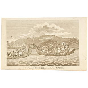
Sold2020c 1781 Engraved Print Captain James Cook's VoyagePrints Capt. James Cook "The Fleet of Otaheite, assembled at Oparee" c. 1781, Engraved Print titled, "The Fleet of Otaheite, assembled at Oparee", Very Fine. Overall size 9.25" x 15". Published in LonSee Sold Price
Featured7 days LeftJasper521796 VOYAGES of CAPTAIN COOK 3 vols 1st US EDITION ILLUSTRATED antique ENGLISH$1,000
2 days LeftFreeman's | HindmanCOOK, James, Captain. The Three Voyages of Captain James Cook. 1842.$175(2 bids)
2 days LeftFreeman's | HindmanCOOK, James, Captain. -- [SECOND VOYAGE]. A Voyage towards the South Pole, and Round the World...$1,500
Jun 13Swann Auction Galleries(HAWAII.) Group of 8 eighteenth-century engraved maps and coastal elevation charts.$1,300
Jun 13Swann Auction Galleries(HAWAII.) James and John Cleveley; and Francis Jukes (engraver). View of Owhyhee One of the Sandwich$1,500
7 days LeftJasper521817 3 VOYAGES of CAPTAIN COOK 6 vols ILLUSTRATED w/ WORLD MAP antique in FRENCH$1,000
Jun 13Swann Auction Galleries(WORLD.) Robert Laurie and James Whittle. A New Map of the World, with Captain Cook's Tracks,$900
3 days LeftEarly American History AuctionsFrench and Indian War 1758 CT. Fiscal Document Signed Joseph Talcott Treasurer to Repay John Ledyard$1,400
1 day LeftHolabird Western Americana CollectionsJourney to Mexico 2 Vols. 1826-34 & 1980 [181944]$200
BonhamsGOLDEN COCKEREL PRESS LAWRENCE (T.E.) Secret Despatches from Arabia, The Golden Cockerel Press (8)£600
3 days LeftTrillium Antique Prints & Rare BooksKohler & Weigel - Map of Louisiana Territory or Eastern United States (extends from New Mexico to$120(4 bids)
3 days LeftTrillium Antique Prints & Rare BooksKohler & Weigel - Map of Sicily and Sardinia$85(2 bids)
2 days LeftHolabird Western Americana CollectionsMap of Africa by Edward Weller c. 1800's [180171]$60


![[Travel & Exploration] Cook, Captain James, A Voyage to: [Travel & Exploration] Cook, Captain James A Voyage to the Pacific Ocean... London: W.A. Strahan for G. Nicol and T. Cadell, 1784. In two volumes, volumes I and II only. First edition. 4to. (12), (1)-](https://p1.liveauctioneers.com/65/168030/84729951_1_x.jpg?height=310&quality=70&version=1588715715)


![COOK, James, Captain. -- [SECOND VOYAGE]. A Voyage towards the South Pole, and Round the World... (1 of 2)](https://p1.liveauctioneers.com/197/329395/177650491_1_x.jpg?height=282&quality=70&version=1715364962)


![Journey to Mexico 2 Vols. 1826-34 & 1980 [181944] (1 of 11)](https://p1.liveauctioneers.com/2699/331494/178785478_1_x.jpg?height=282&quality=70&version=1717094654)


![Arizona Library (5) 1915-67 [182280] (1 of 9)](https://p1.liveauctioneers.com/2699/331494/178785508_1_x.jpg?height=282&quality=70&version=1717094654)


![Map of Africa by Edward Weller c. 1800's [180171] (1 of 2)](https://p1.liveauctioneers.com/2699/331495/178785776_1_x.jpg?height=282&quality=70&version=1717094933)