Sold2023Map Of America & West Indies Principal Harbors Eman BowenDraughts and Plans of Principal Towns and Harbours belonging to the English, French and Spaniards by Eman Bowen 15 3/4 x 18 1/2 (sheet) 18th century framed map.See Sold Price
Sold2017J. Basire: Map of Draught of Ye Bay of Bulls, 1740Map: Draught of Ye Bay of Bulls Between the Town Of Rotta and Fort St. Catherine Maker: James Basire Publisher: Tindal Date: 1740 Size: Folio - 17.5 inches high x 14.75 inches wide "Under the commandSee Sold Price
Sold2021Framed Map of the Dongjing Bay Beibu Wan c1760Framed Map of the Dongjing Bay Beibu Wan 北部湾,c1760 Published by French Cartographer Nicholas Bellin, this pictre has been framed in accordance with museum standards, Frame size H:See Sold Price
Sold2021BRITISH CHANNEL & BAY OF BISCAY MAPWilliam Faden (1749-1836) Framed map of British Channel & Bay of Biscay. Measures 41" x 26.5" with frame.See Sold Price
Sold20231931 Map: Bay of Acre/Acre Anchorage /Haifa Harbour Corrected 1952, 27 1/8" x 39 1/8".1931 Map: Bay of Acre/Acre Anchorage /Haifa Harbour Corrected 1952, 27 1/8" x 39 1/8".See Sold Price
Sold2023MAPS CARTOGRAPHY ITEMS WITH 2 HAND DRAWINGSThe lot includes a framed mid century American map Penobscot Bay And Approaches, United States - East Coast - Maine, Scale 1:80 000; Raritan River From Raritan Bay to New Brunswick New Jersey, Scale 2See Sold Price
Sold2022MAPS CARTOGRAPHY ITEMS WITH 2 HAND DRAWN PIECESThe lot includes a framed mid century American map Penobscot Bay And Approaches, United States - East Coast - Maine, Scale 1:80 000; Raritan River From Raritan Bay to New Brunswick New Jersey, Scale 2See Sold Price
Sold2023Antique Harbour Plan - Map of Bay of Toulon - France, Marseille - MediterraneanTitle: Antique Harbour Plan - Map of Bay of Toulon - France, Marseille - Mediterranean Date/Period: 1804 Dimension: 7” x 9” inches / 17 cm x 23 cm Material: Paper Additional Information: OriginalSee Sold Price
Sold2022Framed Chesapeake Bay MD/VA Nautical ChartFramed nautical chart / map of the Chesapeake Bay, between the Maryland and Virginia border. Map is in excellent condition Paper backing is torn on back of frame and lower right corner of frame has seSee Sold Price
Sold2022Framed Maryland Chesapeake Bay Chart / MapNOAA Chart 12273, Maryland Chesapeake Bay Sandy Point to Susquehanna River. Professionally sealed in frame. Excellent condition. 41"x36.5".See Sold Price
Sold2017Map: Hudson's Bay in North America, 1782, J. BewA framed map: New and Accurate Chart of Hudson's Bay in North America. Published, London Nov. 1782, By J. Bew, Pater Noster Row. Hand colored map, sight measurement 7.25" x 9.25". Framed and matted unSee Sold Price
Sold2017Pearson: Antique Chart of Matanzas Bay, Cuba, 1767Map: A New and Correct Draught of the Bay of Matanzas on ye North side of ye Island Cuba done from a Survey by Robt. Perason Cartographer: Pearson Place & Date: London / 1767 Size: 12" x 9" Condition:See Sold Price
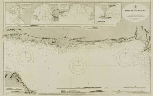
Sold2022Middle East.- Oman.- Admirality Hydrographic Office (The) Maskat to Karachi, engraved chart, 1916.Middle East.- Oman.- Admirality Hydrographic Office (The) Maskat to Karachi, showing the coast from Maskat to Karachi, the Gulf of Oman, with inset maps of Sonmoyani Harbour, Chahbar Bay, Gwatar Bay aSee Sold Price
Sold2024(2) FRAMED MAPS OF MARYLAND, CIRCA 1900Including: St. Michaels of Talbot Co., in black and gold stick frame, matted and glazed, OS: 16 1/2" x 13", SS: 13" x 10"; PLUS Trappe, Oxford & Bay Hundred, also Talbot Co. Similar frame, OS: 23 1/2"See Sold Price
Sold2020Early Framed MapEarly framed map "Various PLAINS and DRAOUGHTS of CITIES, TOWNS, HARBOURS....". Sight 12" x 8 1/2".See Sold Price
Sold2016Map LotLot (3) framed maps including "Carte De La Baye De Hudson" (sight 9 1/4" x 12 1/4"), "The River St. Laurence" (sight 10" x 14 1/2"), "A Plan of the City and Harbour of Louisburg" (sight 11" x 14 1/2")See Sold Price
Sold2021PETE RINDLISBACHER PRINT.Dated 1988. Marked "Perry's Fleet: Put-in-bay Harbour September 10th, 1813" and numbered 574/950. Artist-signed lower right. Framed, 22.75"h. 28"w.See Sold Price
Sold2018NORTH SEA coast chart. East Anglia Holland Flanders.TITLE/CONTENT OF MAP: 'A correct chart of the sea coasts of England, Flanders and Holland. Shewing the sands, shoals, rocks and dangers, the bays, harbours, roads, buoys, beacons & seamarks on the saiSee Sold Price
Sold2018Large Framed 1794 Map of America Laurie & Whittle1794, London New Map of America & The West India Islands. With detailed side maps of California, and Baffin & Hudson Bay. Published by Laurie and Whittle. Map measures approximately 43.5" L x 49.5" H,See Sold Price
Sold2023POLYNESIA/PACIFIC ISLANDS. inc Sandwich/Hawaiian islands. RAPKIN/TALLIS 1851 mapCAPTION PRINTED BELOW PICTURE: 'Polynesia or Islands in the Pacific Ocean' Vignettes: Resolution Bay, Marquesas; Harbour of Dory, New Guinea; Otaheite [Tahiti]; Kalakakooa, Sandwich Islands [HawaiianSee Sold Price
Sold2017Mouzon Map of CarolinasAn Accurate Map of North and South Carolina, with their Indian Frontiers, Shewing in a distinct manner all the Mountains, Rivers, Swamps, Marshes, Bays, Creeks, Harbours, Sandbanks and Soundings on thSee Sold Price
Sold2018POLYNESIA/PACIFIC ISLANDS. inc Sandwich/HawaiianTITLE/CONTENT OF MAP: 'Polynesia or Islands in the Pacific Ocean' Vignettes: Resolution Bay, Marquesas; Harbour of Dory, New Guinea; Otaheite [Tahiti]; Kalakakooa, Sandwich Islands [Hawaiian islands].See Sold Price
6 days LeftThe North Georgia Auction Company LLCClint Alderman Edgefield Area Potteries Map$200(1 bid)
Crawford Family Auctions LLCFramed print of Map of Part of the Island of Hawaii & Sandwich Islands, w/COA$20
3 days LeftMynt AuctionsMort Kunstler Civil War Print Portola Discovers San Francisco Bay Custom Framed$10
4 days LeftHolabird Western Americana CollectionsSanitary & Topographical "Viele Map" of Manhattan 1865 [182838]$750
Jun 10Winter Associates Three historical engraved maps of the Caribbean, ranging from 1616-1814, each hand colored, framed$100(1 bid)
5 days LeftEarly American History Auctions1836 Hand-Colored Map, Country Twenty Five Miles Round The City Of New-York Published by D.S. Stone$260
4 days LeftFreeman's | Hindman[MAP]. ORTELIUS, Abraham. Americae Sive Novi Orbis, Nova Descriptio. 1573.$1,000(1 bid)
4 days LeftFreeman's | HindmanBELLIN, Jacques-Nicolas. Carte Reduite de L'Ocean Oriental ou Mer Des Indies. Paris, 1757. Second$150


![POLYNESIA/PACIFIC ISLANDS. inc Sandwich/Hawaiian islands. RAPKIN/TALLIS 1851 map: CAPTION PRINTED BELOW PICTURE: 'Polynesia or Islands in the Pacific Ocean' Vignettes: Resolution Bay, Marquesas; Harbour of Dory, New Guinea; Otaheite [Tahiti]; Kalakakooa, Sandwich Islands [Hawaiian](https://p1.liveauctioneers.com/5584/298779/159029476_1_x.jpg?height=310&quality=70&version=1692132475)

![POLYNESIA/PACIFIC ISLANDS. inc Sandwich/Hawaiian: TITLE/CONTENT OF MAP: 'Polynesia or Islands in the Pacific Ocean' Vignettes: Resolution Bay, Marquesas; Harbour of Dory, New Guinea; Otaheite [Tahiti]; Kalakakooa, Sandwich Islands [Hawaiian islands].](https://p1.liveauctioneers.com/5584/128489/65352606_1_x.jpg?height=310&quality=70&version=1538523113)


![Sanitary & Topographical "Viele Map" of Manhattan 1865 [182838] (1 of 3)](https://p1.liveauctioneers.com/2699/331495/178785766_1_x.jpg?height=282&quality=70&version=1717094933)


![[MAP]. ORTELIUS, Abraham. Americae Sive Novi Orbis, Nova Descriptio. 1573. (1 of 2)](https://p1.liveauctioneers.com/197/329395/177650534_1_x.jpg?height=282&quality=70&version=1715364962)
![[MAP]. SPEED, John. A New Mappe of the Romane Empire. 1676. (1 of 2)](https://p1.liveauctioneers.com/197/329395/177650541_1_x.jpg?height=282&quality=70&version=1715364962)

