Sold2023James Cook Antiquated MapAntiquated framed and glazed map / 'agenera chart' depicting the voyages and discoveries of Captain James Cook height 28 in. x width 42 in. x depth 1.5 in. We happily provide seamless shippiSee Sold Price
Sold2023T Bowen Early Antique Map incl Discoveries by Captain Cook in North AmericaT Bowen Early Antique Map incl Discoveries by Captain Cook in North America MEDIUM: Printed and Published DIMENSIONS: 9.75 X 8.25 inches CIRCA: 1780 ATTRIBUTION: T. Bowen DESCRIPTION: This lot is a fiSee Sold Price
Sold2021Antique Map of Captain James Cook's Voyages to theAntique map of Captain James Cook's voyages to the Pacific region. Captain Cook made numerous discoveries in the Pacific region during the late 1700's . Artists and mapmakers aboard the ship, includinSee Sold Price
Sold2023La Mappe Monde- Map of 3 Voyages of Captain CookAntique Map Print- La Mappe Monde, Depicting the Three Voyages of Captain Cook. Original was Drawn by Herisson, Hand Watercolored, Number 64 and Dated 1816. Measures 33 1/2" x 47" framed. Good ConditiSee Sold Price
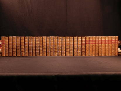
Sold20181780 1ed RARE Complete VOYAGES Maps Captain Cook Americ1780 1ed RARE Complete VOYAGES Maps Captain Cook America Explorers Africa 32v The best book of its kind! An extremely rare, 32-volume complete set of La Harpe’s ‘General History of Voyages’! ThiSee Sold Price
Sold20181780 1ed RARE Complete VOYAGES Maps Captain Cook1780 1ed RARE Complete VOYAGES Maps Captain Cook America Explorers Africa 32v The best book of its kind! An extremely rare, 32-volume complete set of La Harpe’s ‘General History of Voyages’! ThiSee Sold Price
2017Tallis/Rapkin: Antique Map of Captain Cook's VoyageTitle/Content of Map: 'The World on Mercator's Projection shewing the voyages of Captain Cook around the World' The track's of Cook's first, second and third voyages are shown, along with dates. DateSee Sold Price
Sold20221836 1ed Oceania Rienzi Polynesia Voyages MAPS Australia Captain Cook Pacific1836 1ed Oceania Rienzi Polynesia Voyages MAPS Australia Captain Cook Pacific Louis de Rienzi was a 19th-century French voyager who is remembered for his 1836 masterwork Oceania, or Fifth Part of theSee Sold Price
Sold2022c. 1781 Captain Cook Voyages Map, London by Alexander HoggHistoric Maps "A Plan of Success Bay in Strait Le Maire / A Chart of the S.E. part of Terra del Fuego... by Captn. Cook 1769" c. 1781, A "Dual" Map from Captain Cook's Voyages, titled: "A Plan of SuccSee Sold Price
Sold2022c. 1781 Captain Cook Voyages Map, London by Alexander HoggHistoric Maps "A Plan of Success Bay in Strait Le Maire / A Chart of the S.E. part of Terra del Fuego... by Captn. Cook 1769" c. 1781, Dual Map from Captain Cook's Voyages, titled: "A Plan of SuccessSee Sold Price
Sold20191836 1ed Oceania Rienzi Polynesia Voyages MAPS1836 1ed Oceania Rienzi Polynesia Voyages MAPS Australia Captain Cook Pacific Louis de Rienzi was a 19th-century French voyager who is remembered for his 1836 masterwork ‘Oceania, or Fifth Part of tSee Sold Price
Sold20181780 1ed VOYAGES Captain Cook Maps Comm Byron America1780 1ed VOYAGES Captain Cook Maps Comm Byron America Explorers Africa 3v La Harpe The best book of its kind! A rare set of La Harpe’s ‘General History of Voyages’! This extensive work was begunSee Sold Price
Sold2023C. 1779, ANTARCTICA & CAPTAIN COOK'S TRAVELS MAPAntonio Zatta (Italian fl. 1775-1797), "Emisfero Terrestre Meridionale Tagliato su l'Equatore", circa 1779, hand colored etching on paper depicting map of Antarctica and Captain Cook's travels, unframSee Sold Price
Sold20231876 Atlas of Illinois- Cook County Map Framed PagTravel back in time to the late 19th century with this enchanting Framed Map Page from the 1876 Atlas of Illinois by Warner & Beers. This exquisite piece showcases the detailed cartography of Cook, DuSee Sold Price
Sold2023Captain John Bonner Framed Map of BostonPrinting by George C. Smith of Capt. John Bonner's "The Town of Boston in New England". Frame measures approximately 27.5" x 21.75". Original price was $300.00 (see last photo). Estimated shipping cosSee Sold Price
2017New Map of the World with Captain Cooks Tracks, 1794New Map of the World with Captain Cooks Tracks, Western & Northern Hemisphere. 40 x 30 in. dated May 11, 1794. Reproduction. Please note that this lot has a reserve. When you leave a bid in advance ofSee Sold Price
Sold2020A Regency 22-Inch Terrestrial Floor Globe by John andA Regency 22-Inch Terrestrial Floor Globe by John and William Cary London, Early 19th Century labeled Cary's/ New/ Terrestrial Globe/ Exhibiting/ The Tracks and Discoveries made by/ Captain Cook/ AlsoSee Sold Price
Sold2022Extraordinary Book of Engravings from Captain Cook's Voyages, c. 1784First Edition, c. 1784. 60 copperplate engravings drawn by John Webber (1751-1793) on chain-laid paper. Depicting images from the three voyages of Captain Cook. Contains a foldout map at the rear. PrSee Sold Price
Sold2019The Journals of Captain James CookHeading: Author: Cook, James Title: The Journals of Captain James Cook on His Voyages of Discovery Place Published: Sydney Publisher:Boydell Press Date Published: [1999] Description: <See Sold Price
Sold20221776 Gentlemans Magazine, Port Bill + Capt. CookAmerican Revolution 1776 "Boston in Distress" & "Account of the Proceedings of the American Colonists since Passing the Boston Port Bill" and "Discoveries of the Resolution Sloop, Captain Cook in 1774See Sold Price
Sold2019Engavings of the Death of Capt. James CookHeading: (Cook, James) Author: Title: Six engravings depicting the Death of Captain James Cook, matted and framed together Place Published: France? Publisher: Date Published: c. late 18th-eaSee Sold Price
Sold2023A dance in Otaheite (Tahiti) - Antique steel engravingThis antique steel engraving was made in XIX century from a drawing by John Webber (1752-1793), who was the artist on Captain James Cook's 3rd and final voyage of discovery. Size: 27x20,2 cms. PublishSee Sold Price
Sold2023Map of French Senegal and New Guinea 1727Framed map of French Senegal and New Guinea 1727 illuminated manuscript French framed- Nice condition.See Sold Price
Sold20241784 Captain Cook's Third Voyage 3V1784 A Voyage to the Pacific Ocean. Undertaken, by the Command of His Majesty, for Making Discoveries in the Northern Hemisphere. Performed under the Direction of Captains Cook, Clerke, and Gore, in HSee Sold Price
Jun 13Swann Auction Galleries(WORLD.) Robert Laurie and James Whittle. A New Map of the World, with Captain Cook's Tracks,$900
Featured6 days LeftJasper521796 VOYAGES of CAPTAIN COOK 3 vols 1st US EDITION ILLUSTRATED antique ENGLISH$1,000
6 days LeftJasper521817 3 VOYAGES of CAPTAIN COOK 6 vols ILLUSTRATED w/ WORLD MAP antique in FRENCH$1,000
Jun 12Jasper52The World including the late discoveries by Captn Cook… by Thomas BOWEN 1789 map$500
Jun 13Swann Auction Galleries(HAWAII.) Group of 8 eighteenth-century engraved maps and coastal elevation charts.$1,300
2 days LeftFreeman's | HindmanCOOK, James, Captain. The Three Voyages of Captain James Cook. 1842.$175(2 bids)
Jun 13Swann Auction Galleries(HAWAII.) James and John Cleveley; and Francis Jukes (engraver). View of Owhyhee One of the Sandwich$1,500
BonhamsGOLDEN COCKEREL PRESS LAWRENCE (T.E.) Secret Despatches from Arabia, The Golden Cockerel Press (8)£600
2 days LeftFreeman's | HindmanCOOK, James, Captain. -- [SECOND VOYAGE]. A Voyage towards the South Pole, and Round the World...$1,500


![The Journals of Captain James Cook: Heading: Author: Cook, James Title: The Journals of Captain James Cook on His Voyages of Discovery Place Published: Sydney Publisher:Boydell Press Date Published: [1999] Description: <](https://p1.liveauctioneers.com/642/156449/78960201_1_x.jpg?height=310&quality=70&version=1575314552)


![COOK, James, Captain. -- [SECOND VOYAGE]. A Voyage towards the South Pole, and Round the World... (1 of 2)](https://p1.liveauctioneers.com/197/329395/177650491_1_x.jpg?height=282&quality=70&version=1715364962)


