2016Map of Egypt. Africa. 1835.Print of hand colored steel engraving titled „Egypte“.Author C. V. Monin.Engraved by unknown.From the „Atlas Universel de Geography“ by C. V. Monin. Parsi. 1835.Egypt officially the Arab RepubSee Sold Price
Sold2018Smith/Burgess: Antique Map of Africa, 1835Title/Content of Map: 1835 Smith/Burgess Map of Africa -- Africa Date Printed: 1835, Hartford Cartographer: C Smith / D Burgess Size: 8.7 x 10.4 in. This is a very nice map of Africa from the early 19See Sold Price
Sold2018Early Map Egypt Nubia AfricaDe l'Egipte. Antique map by Clouet, Paris, 1730. Egypt, Nubia, Abyssinia, Middle East, Asia. . 16" x 24.See Sold Price
Sold2017Bradford: Antique Map of Egypt, 1835Map: Egypt by Bradford Date Printed: 1835 Cartographer: T. G. Bradford Material/Medium: Paper Size: 11 1/2" x 10" Hand colored outlines. Published in Boston. From 'A Comprehensive Atlas Geographical,See Sold Price
Sold2022Cellarius & Patrick 1816 Map. Egypt, North Africa"Aegyptus Marmarica et Cyrenaica" Copper Engraved Map Published 1816, London for "Geographia Antiqua" by Samuel Patrick. Maps based on those by Andreas Cellarius. Folds as issued. Paper Size: 10 x 8 iSee Sold Price
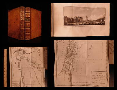
Sold20191799 Voyages in Syria & EGYPT Africa Illustrated MAPS1799 Voyages in Syria & EGYPT Africa Illustrated MAPS Sphinx Pyramids 2v Volney Constantin-François Volney, an 18th-century French philosopher known for his historical works on archaeology and travelSee Sold Price
Sold20201787 1st ed Voyages in Syria & EGYPT Africa Illustrated1787 1st ed Voyages in Syria & EGYPT Africa Illustrated MAPS Sphinx 2v Volney “The best expose of Ottoman Empire at the end of the 18th-century!” (Blackmer) Constantin-François Volney, an 18th-ceSee Sold Price
Sold2018Mercator: Antique Map of Egypt and of N Africa, 1578Title/Content of Map: 1578 Mercator Map of Egypt and Parts of N Africa -- Afr. III Tab. Date Printed: 1578 Amsterdam Cartographer: G. Mercator Size: 13.25 x 18 in. This is a detailed map of NortheastSee Sold Price
Sold20191854 Journey to Central Africa EGYPT Sudan Ethiopia MAP1854 Journey to Central Africa EGYPT Sudan Ethiopia MAP Nile Bayard Taylor Bayard Taylor was a 19th-century travel writer whose abundant notes and reports have been referenced for decades since the miSee Sold Price
Sold20211747 Map of Ancient Africa EgyptA map of "Africa ex Bello Africano C I Caesaris", with inset of Egypt at the time of the Roman Empire. Printed at London by Knapton, 1747. Map measures 9.97 x 6.75" with extra wide left margin. Fine.See Sold Price
Sold20191866 1ed Albert N’Yanza Nile Tributaries Africa Egypt1866 1ed Albert N’Yanza Nile Tributaries Africa Egypt Abyssinia Illustrated Map Samuel White Baker was an English naturalist, big game hunter, explorer and was the first Englishman to sit in a highSee Sold Price
Sold20211874 Journey to Central Africa Lakes EGYPT Sudan1874 Journey to Central Africa Lakes EGYPT Sudan Ethiopia MAP Nile Bayard Taylor Bayard Taylor was a 19th-century travel writer whose abundant notes and reports have been referenced for decades sinceSee Sold Price
Sold20201856 Map of North East AfricaTitle: 1856 Map of North East Africa Medium: Ink on Paper Dimensions: 14.5"X17.5" Map of the North Eastern part of Africa. This map captures Egypt, Libia and surroundings. Engraved and published by J.See Sold Price
Sold2020Cornwell & Dower 1849 Pair of Miniature Maps of AfricaNorth/South Africa and Africa Physical/Egypt. Steel Engraved Maps Published 1849, London for "A School Atlas" by James Cornwell. Maps by John Dower. Paper Size: 6.5 x 4 inch (16 x 10cm)See Sold Price
Sold2023Ptolemy, Fries, pub. 1535 - Map of Northern Africa and EgyptThis important historic map is from Geographicae enarrationis libri octo Ex Bilibaldi Pirckeymheri tralatione, fed ad Graeca & prisca exemplaria.... The work was published in 1535 in Lyon after LorenzSee Sold Price
Sold2022Antique Map Print - South Africa - Algeria - Egypt - PalestineSet of 4 Map Prints. Antique lithographic map originates from "Letts's Popular Atlas", being a series of maps delineating the whole surface of the globe, with many special and original features; and aSee Sold Price
Sold20241849 Mitchell School ATLAS 24 MAPS America Holy Land France Africa Egypt Asia1849 Mitchell School ATLAS 24 MAPS America Holy Land France Africa Egypt Asia The name Mitchell has long been synonymous with 19th-century maps; in fact, Mitchell maps are often considered the best ofSee Sold Price
Sold20171833 Nubia & Abyssinia EGYPT Ethiopia Africa Missions1833 Nubia & Abyssinia EGYPT Ethiopia Africa Missions Geography MAP Bishop Michael Russell was a 19th-century historian who was well-versed in a variety of subjects, including Biblical and Holy Land hSee Sold Price
Sold2020Brockhaus (Pub) 1890's Lot of 5 Maps of AfricaAfrica continent, Egypt and Equatorial Africa. Lithograph Maps 1892-98 by F. A. Brockhaus, Leipzig for "Brockhaus' Konversations-Lexikon" by Various. Centre fold as issued. Paper Size: 12 x 10 inch (3See Sold Price
Sold20241801 AFRICA RELATIONS 2 VOLUMES antique Carthage Ethiopia Egypt MAPHÉEREN (A. H. L.). Idées sur les relations politiques et commerciale des anciens peuples de l’Afrique. [ Ideas on the political and commercial relations of the ancient peoples of Africa. ] 2 volumSee Sold Price
Sold2024North East Africa. Egypt Abyssinia Arabia Abu Dhabi Sharja. COLTON 1869 mapTITLE OF MAP (NOT PRINTED ON THE PAGE):'Africa - north eastern sheet' DATE PRINTED: 1869 IMAGE SIZE: Approx 42.0 x 33.5cm, 16.5 x 13.25 inches (Large) TYPE: Antique engraved hand coloured atlas map COSee Sold Price
Sold20231895 AFRICA Morocco EGYPT Sudan Sierra Leonne Sahara Illustrated MAPS 2v SET1895 AFRICA Morocco EGYPT Sudan Sierra Leonne Sahara Illustrated MAPS 2v SET Augustus Keane was a 19th-century historian and author whose studies in ethnology resonate with even modern day ethnologistSee Sold Price
Sold2022Times Atlas 1895 Lot of 4 Maps of AfricaIncl Egypt, South Africa, West Africa Colonial, and Africa North West. Lithograph Maps Published 1895, London for "The Times Atlas" Paper Size: Up to 21 x 16 inch (54 x 41cm) Good ConditionSee Sold Price
Sold2022Times Atlas 1895 Lot of 7 Maps of AfricaIncl West Africa Colonial, South Africa, Egypt, South Africa, Africa North West and Africa General. Lithograph Maps Published 1895, London for "The Times Atlas" Centre fold as published. Paper Size: USee Sold Price
5 days LeftJasper52NORTH AFRICA. Barbary. Morocco Tunisia Libya Egypt. 'Barbarie'. MALLET 1683 map$20
5 days LeftJasper52NORTH AFRICA OF BABRBARY V Parts of Tripoli & Egypt. Libya Tribes. SDUK 1846 map$15
5 days LeftJasper52NORTH AFRICA OF BABRBARY V Parts of Tripoli & Egypt. Libya Tribes. SDUK 1851 map$20
BonhamsEAST AFRICA DE WIT (FREDERICK) Occidentalior Tractus Indiarum Orientalium a Promontorio Bonae Sp...£300
5 days LeftJasper52NILE VALLEY. Upper & Lower. Egypt Sinai Nubia Sudan Abyssinia. BLACKIE 1886 map$20
BonhamsBOTELER (THOMAS) Narrative of a Voyage of Discovery to Africa and Arabia, 2 vol., FIRST EDITION;...£600
5 days LeftJasper52COLONIAL AFRICA. British French German Italian Portugal Spain.STANFORD 1906 map$15
5 days LeftJasper52ANCIENT NORTH AFRICA Septentrionalis. Mauretania Tripolitana ARROWSMITH 1828 map$15
5 days LeftJasper52Colonial Southern Africa. British Portuguese German. Madagascar. TIMES 1900 map$15
5 days LeftJasper52WEST AFRICA. British Cameroons & Togoland mandates. Gold Coast Nigeria 1947 map$20


![1801 AFRICA RELATIONS 2 VOLUMES antique Carthage Ethiopia Egypt MAP: HÉEREN (A. H. L.). Idées sur les relations politiques et commerciale des anciens peuples de l’Afrique. [ Ideas on the political and commercial relations of the ancient peoples of Africa. ] 2 volum](https://p1.liveauctioneers.com/5584/318267/170789234_1_x.jpg?height=310&quality=70&version=1707248973)


