Sold2020Texas, Indian Terratory 1888Title/Content of Map: Texas, Indian Terratory 1888 Date Printed: 1888 Material/Medium: paper Size: approx 11x14 inches Additional Info: John C. Lonngren & Son Standard Atlas of the World Reserve: $20See Sold Price
Sold2018DANIEL MALDONADO (TEXAS), INDIAN LANDSCAPE 30"x40"Unframed oil painting on canvas, Peaceful Morning, A Native American Landscape, signed lower right Maldonado (Daniel Maldonado, Texas, 20th/21st c.), 30"h, 44"w Start Price: $800.00See Sold Price
Sold2018Jim Powell (20th Cent. Texas) Indians on HorsebackJim Powell (20th Cent. Texas) Indians on Horseback Crossing a River Watercolor on Paper 21''x29'' Image. A colorful western landscape with several Indian hunters on horseback. Signed l.r. Framed 31.5'See Sold Price
Sold2022CORNER TANG KNIVES ACROSS TEXAS INDIAN ARTIFACT ARROWHEADEVERY BEAUTIFUL NATIVE AMERICAN INDIAN ARTIFACT IS FROM THE LARRY SHAVER COLLECTION, HE FOUND HIS FIRST ARROWHEAD IN 1951 AT THE AGE OF 12 & COLLECTED UNTIL THE TIME OF HIS DEATH. HE HAD A VERY LARGESee Sold Price
Sold2022Uncommon Texas/Indian Territory RR map, 1890Unusual map of Texas and Indian Territory by McNally showing highly detailed picture of Native American tribe locations in Indian Territory. Presents a thorough overview of railroad lines in the regioSee Sold Price
Sold2022Map of Texas, Indian Terr., Mississippi, etc.- OlneyNice hand-colored school atlas map of the near Southwest. “No. 8 Mississippi, Arkansas, Louisiana, Texas, Indian Territory.” From Olney’s 1849 school atlas. Clean with a tiny spot iSee Sold Price
Sold2022Scarce 1st ed. Northern Texas/Indian Territory, Tunison 1885Beautiful and scarce double-page chromolithographic map of Northern Texas and Indian Territory. From the 1885 edition of Tunison’s Peerless Universal Atlas of the World. WorldCat lists this atlaSee Sold Price
Sold20211869 McNally Map of Texas, Indian Territory and NewTitle: 1869 McNally Map of Texas, Indian Territory and New Mexico -- Texas, New Mexico, and Indian Territory Cartographer: F McNally Year / Place: 1869, New York Map Dimension (in.): 8.3 X 10.6 in. ThSee Sold Price
Sold2016Cram: Map of Texas, Indian TY, Colorado, 1884Map: Texas, Indian TY, Colorado Maker: George Cram Date: 1884 Origin: Chicago Size: 11.8 x 17 inches (9.5 x 12 verso) Handsomely detailed map of Texas, with the Panhandle as insert. Colorado and IndiaSee Sold Price
Sold2017Fullarton: Antique Map of Texas & Indian Territory 1860Map: 1860 Fullarton Map of Texas (East/Central), Indian Territory, Louisiana and Arkansas -- United States North America According to Calvin Smith& Tanner . . . South Central Section. Comprising TexasSee Sold Price
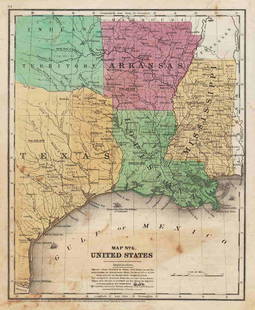
Sold2017Cram: Antique Map of Texas, Indian Territory, ArkansasTitle/Content of Map: 1885 Cram Map of Texas, [verso] Indian Territory and Arkansas -- Texas, [verso] Indian Ty; Arkansas Date Printed: 1885, Chicago Cartographer: G Cram Size: 12 x 17 in. This is a nSee Sold Price
Sold2022New Mexico & Indian Terratory 1889Title/Content of Map: New Mexico & Indian Terratory 1889 Date Printed: 1889 Material/Medium: paper Size: approx 10.5"x13.50" Additional Info: Mast, Crowell & Kirkpatrick Reserve: $35.00 Shipping: DomeSee Sold Price
Sold2017Rand McNally: Antique Map of Texas & Indian TerritoryMap: 1895 Rand McNally Map of Texas and Indian Territory/Oklahoma -- Texas; Oklahoma and Indian Territory Cartographer: Rand McNally Year / Place: 1895 Chicago Map Dimensions: 9.2 x 12.5 in. ConditionSee Sold Price
Sold2017Rand McNally: Antique Map of Texas & Indian TerritoryTitle/Content of Map: 1895 Rand McNally Map of Texas and Indian Territory/Oklahoma -- Texas; Oklahoma and Indian Territory Date Printed: 1895 Chicago Cartographer: Rand McNally Size: 9.2 x 12.5 in. CoSee Sold Price
Sold2022Texas, Indian Terr. and SW states, Steinwehr 1870Striking map from 1870 school atlas. Shows military posts, tribes, railroads, cities and towns in Texas, Arkansas, Mississippi, "Indian Territory," and Louisiana, and public lands. Printed color. MapSee Sold Price
Sold2017Cram: Map of Texas, Indian Terretory, Arkansas, 1885Map: 1885 Cram Map of Texas [verso] Indian Terretory [and] Arkansas -- Texas [verso] Indian Ty. [and] Arkansas Cartographer: G Cram Year / Place: 1885, Chicago Map Dimensions: 11.8 x 17 in. A very detSee Sold Price
Sold2022Ancient Caddo Texas Indian Pottery Pot VesselFound in Bowie County Texas. 3 1/8" tall, 2 3/4" diameter. Allard Auction Collection Inv: AXSee Sold Price
Sold2019ARROW POINT FROM TEXAS INDIAN ARTIFACT ARROWHEADTHIS BEAUTIFUL NATIVE AMERICAN INDIAN ARTIFACT IS 2&1/4 INCHES LONG. IT IS FROM TEXAS. IT WILL MAKE A GREAT ADDITION TO YOUR COLLECTION! KEY WORDS: NATIVE AMERICAN INDIAN ARTIFACT ARTIFACTS ARROWHEADSee Sold Price
Sold2022Oklahoma In Indian Terratory 1897Title/Content of Map: Oklahoma In Indian Terratory 1897 Date Printed: 1897 Material/Medium: Paper Size: Approx. 14.5x11.25 inches Additional Info: Cram's Universal Atlas, Chicago Reserve: $35.00 ShippSee Sold Price
Sold2020New Mexico, Indian Terratory 1889Title/Content of Map: New Mexico, Indian Terratory 1889 Date Printed: 1889 Material/Medium: paper Size: approx 13.5x11 inches Additional Info: The Peerless Atlas. Published by Mast, Crowell & KirkpatrSee Sold Price
Sold20211847 map showing east Texas/Indian TerritoryInteresting map of the southern U. S. in 1847. Map by Cady & Burgess from Roswell SmithÂ’s 1847 Quarto Atlas. Eastern portion of Texas shown along with most of Indian Territory. Also includes ArkanSee Sold Price
Sold2022Oklahoma & Indian Terratory 1900Title/Content of Map: Oklahoma & Indian Terratory 1900 Date Printed: 1900 Material/Medium: Paper Size: approx 10.5x14 inches Additional Info: Public Ledger's Unrivaled Atlas (Rand McNally) Reserve: $3See Sold Price
Sold2022DIGGING INTO SOUTH TEXAS INDIAN ARTIFACT ARROWHEADEVERY BEAUTIFUL NATIVE AMERICAN INDIAN ARTIFACT IS FROM THE LARRY SHAVER COLLECTION, HE FOUND HIS FIRST ARROWHEAD IN 1951 AT THE AGE OF 12 & COLLECTED UNTIL THE TIME OF HIS DEATH. HE HAD A VERY LARGESee Sold Price
2022Oklahoma & Indian Terratory 1900Title/Content of Map: Oklahoma & Indian Terratory 1900 Date Printed: 1900 Material/Medium: Paper Size: approx 10.5x14 inches Additional Info: Public Ledger's Unrivaled Atlas (Rand McNally) Reserve: $3See Sold Price
Jun 07Freeman's | HindmanYOUNGBLOOD, Charles L. Adventures of... During Ten Years on the Plains. 1882. FIRST EDITION.$200
3 days LeftRipley AuctionsKen Fleisch, Texas (1943-2008), still life with Kachina, oil on canvas, 23 3/4"H x 29 3/4"W (sight),$500
4 days LeftSchilb Antiquarian Rare Books1888 Civil War 1st ed General Sheridan Personal Memoirs Union Native Americans$155(4 bids)
3 days LeftRichmond Auctions1940 Indian Gasoline Curved SSP Pump Plate Sign w/ The Texas Co Attachment$100(2 bids)
Jun 23Schilb Antiquarian Rare Books1888 Civil War 1st ed General Sheridan Personal Memoirs Union Native Americans$13(3 bids)
218 Lots AwayChampagne AuctionsUSA Indian Cent 1876-1909 A Lot of 21 Mixed Dates Good-FineCA$30(1 bid)


![Cram: Antique Map of Texas, Indian Territory, Arkansas: Title/Content of Map: 1885 Cram Map of Texas, [verso] Indian Territory and Arkansas -- Texas, [verso] Indian Ty; Arkansas Date Printed: 1885, Chicago Cartographer: G Cram Size: 12 x 17 in. This is a n](https://p1.liveauctioneers.com/5584/113749/58452563_1_x.jpg?height=310&quality=70&version=1513734097)


![Cram: Map of Texas, Indian Terretory, Arkansas, 1885: Map: 1885 Cram Map of Texas [verso] Indian Terretory [and] Arkansas -- Texas [verso] Indian Ty. [and] Arkansas Cartographer: G Cram Year / Place: 1885, Chicago Map Dimensions: 11.8 x 17 in. A very det](https://p1.liveauctioneers.com/5584/104739/53636876_1_x.jpg?height=310&quality=70&version=1496416470)