


1730 Covens & Mortier Map of Parts of Coastal Brazil --
Similar Sale History
View More Items in Maps & Atlases


Related Maps & Atlases


More Items in Maps & Atlases
View More


Recommended Transportation & Travel Collectibles
View More


Item Details
Description
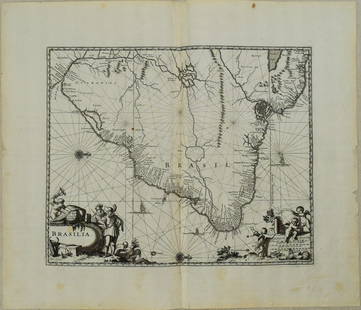
This unusual map of the Brazilian coast is adorned with a massive garland across the top bearing plenty of native fruit and three centrally placed animals -- jaguar, tapir, and capybara. With north oriented to the right, the map covers the coastal region of today's State of Sergipe from Sao Francisco River to south to the mouth of the Vaza-Barris River. Sergipe is located between Recife and Salvador. The map traces the rivers inland with place names and topographical detail along their shores. There is a naval skirmish, three Dutch ships, and a canoe off the coast in the Atlantic. This is among the first maps of Brazil based on non-Portuguese data. Blaeu first issued this map, and this is Covens and Mortier's later version.
Reserve: $240.00
Shipping:
Your purchase is protected:
Photos, descriptions, and estimates were prepared with the utmost care by a fully certified expert and appraiser. All items in this sale are guaranteed authentic.
In the rare event that the item did not conform to the lot description in the sale, Jasper52 specialists are here to help. Buyers may return the item for a full refund provided you notify Jasper52 within 5 days of receiving the item.
Condition
Fair. Soiling. Toning. Several smaller voids in the lower portions. Several splits repaired on verso, one with adhesive blead-though in lower portion. Narrow margins. Issued fold. Color outline.
Buyer's Premium
- 15%
1730 Covens & Mortier Map of Parts of Coastal Brazil --
Estimate $300 - $350
2 bidders are watching this item.
Shipping & Pickup Options
Item located in Ohio, US$19 shipping in the US
Payment
Accepts seamless payments through LiveAuctioneers
See More Items From This Jasper52 Seller

Related Searches
TOP