


Zatta: Canada bet. James Bay & Ottawa River
Similar Sale History
View More Items in Maps & Atlases

![[ATLASES]. Lot of 3 Folio Atlas sold together: [ATLASES]. Lot of 3 Folio Atlas sold together. Including: Black’s General Atlas of The World. Edinburgh:Adam and Charles Black. 1888. ** Department of The Interior. Atlas of Canada. Ottawa, 191](https://p1.liveauctioneers.com/1124/187577/94368834_1_x.jpg?height=310&quality=70&version=1607095126)


![[MAP] VALCK. MAPPE-MONDE GEO-HYDROGRAPHIQUE (1686): Valck, Gerard. MAPPE-MONDE GEO-HYDROGRAPHIQUE, OU DESCRIPTION GENERAL DU GLOBE TERRESTRE ET AQUATIQUE EN DEUX-PLANS-HEMISPHERES... Amsterdam, (circa 1686). Beautiful map, fully handcoloured, richly de](https://p1.liveauctioneers.com/8124/310027/165853628_1_x.jpg?height=310&quality=70&version=1700184289)
![[MAP] DE WIT, F. NOVA ORBIS TABULA IN LUCEM EDITA: de Wit, Frederik. NOVA ORBIS TABULA, IN LUCEM EDITA. (Amsterdam: circa 1670s.) Beautiful map in exquisite full handcolouring, with elaborate corner scenes illustrating the four seasons and the Zodiac,](https://p1.liveauctioneers.com/8124/310027/165853624_1_x.jpg?height=310&quality=70&version=1700184289)
Related Maps & Atlases


![De Bry & Vopel Map of the Rhine River: DE BRY, Theodor de (1528-1598) after Caspar Vopel (1511–1561). [Rhine River Map] Rheni Tricornis et Vvidi Nova et Germana Descriptio, Additis Fluminibus... Engraved map. Frankfurt: T. de Bry, 1594.](https://p1.liveauctioneers.com/1968/330639/178336641_1_x.jpg?height=310&quality=70&version=1716827770)

More Items in Maps & Atlases
View More
![[Maps & Atlases] Oliva, Joan: Portolan Chart of the Mediterranean: [Maps & Atlases] Oliva, Joan: Portolan Chart of the Mediterranean Oliva, Joan Portolan Chart of the Mediterranean Marseille, 1615. Illuminated manuscript portolan chart on vellum, in red, blue, green,](https://p1.liveauctioneers.com/65/332523/179335172_1_x.jpg?height=310&quality=70&version=1717709445)

![Set of Twelve Satirical Anthropomorphic Maps of Europe: [SATIRICAL MAPS] A set of twelve satirical anthropomorphic maps of Europe. London: circa 1868. A set of 12 (believed complete) lithographed maps by Vincent Brooks, Day & Son, London, each offering](https://p1.liveauctioneers.com/292/330597/178279264_1_x.jpg?height=310&quality=70&version=1716409282)


![[Maps & Atlases] Speed, John: The Turkish Empire: [Maps & Atlases] Speed, John: The Turkish Empire Speed, John The Turkish Empire (London): Roger Rea the Elder and younger, 1626 (but, 1662 or after). Engraved hand-colored map, 16 3/4 x 21 1/2 in. (42](https://p1.liveauctioneers.com/65/332523/179335176_1_x.jpg?height=310&quality=70&version=1717709446)


Recommended Transportation & Travel Collectibles
View More


Item Details
Description
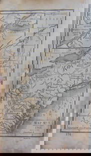
The highly detailed map of western New France, or the region between James Bay, Lake Mistassini (Lac Mistassine), Lake Huron and, in the lower right corner, "Monreal," from Zatta's 1778 12-sheet version of Mitchell's landmark map of North America. Includes many place names, roads, notes on native tribes, and a clearly delineated boundary of the Six Nations territory.
Please note that this lot has a confidential reserve. When you leave a bid in advance of the auction, submit your maximum. The bidder who has submitted the highest bid wins the lot, provided the bid exceeds the reserve price.
Shipping:
Your purchase is protected:
Photos, descriptions, and estimates were prepared with the utmost care by a fully certified expert and appraiser. All items in this sale are guaranteed authentic.
In the rare event that the item did not conform to the lot description in the sale, Jasper52 specialists are here to help. Buyers may return the item for a full refund provided you notify Jasper52 within 5 days of receiving the item.
Buyer's Premium
- 15%
Zatta: Canada bet. James Bay & Ottawa River
Estimate $80 - $100
Get approved to bid.
Shipping & Pickup Options
Item located in New York, US$17 shipping in the US
Payment
See More Items From This Jasper52 Seller

Auction Curated By

Maps Expert
Related Searches
TOP