


[Map] Map of Jerusalem, 18th century
Similar Sale History
View More Items in Maps & Atlases


![1590 Map of Jerusalem from "Civitates Orbis Terrarum" by Hogen & Bran: 1590 Map of Jerusalem from "Civitates Orbis Terrarum" by Hogen & Bran 1p, measuring 21" x 16", [Cologne, Germany], undated [Ca. 1590]. A beautiful color copper etching map of Jerusalem, printed in](https://p1.liveauctioneers.com/6306/250544/130128283_1_x.jpg?height=310&quality=70&version=1654115529)


Related Maps & Atlases


![The "Silent [Zeppelin airship] raid" on the night of 19-20th Oct 1917 1925 map: TITLE/CONTENT OF MAP: 'Map of the "Silent raid" on the night of 19th./20th. Oct., 1917' The map shows the tracks of Zeppelin airships L41 L44 L45 L46 L47 L49 L50 L53 L54 & L55 DATE PRINTED: 1925 IMAGE](https://p1.liveauctioneers.com/5584/328641/177014282_1_x.jpg?height=310&quality=70&version=1715113718)


![Europe after the Congress of Vienna. 4 sheets. 128x106cm. THOMSON 1817 old map: TITLE/CONTENT OF MAP: A map of Europe, with the political divisions after the Peace of Paris and Congress of Vienna [4 sheets] This very large map, printed on 4 sheets, shows a re-aligned Europe after](https://p1.liveauctioneers.com/5584/328641/177014440_1_x.jpg?height=310&quality=70&version=1715113718)
More Items in Maps & Atlases
View More
![[Maps] Gio. Ant. Magnini, Italia, 1620: [Maps] Gio. Ant. Magnini, Italia, 1620, Giovanni Antonio Magnini. Italia, data in luce da Fabio suo figliuolo al Serenissimo Ferdinado Gonzaga Duca di Matoua edi Monserrato etc. Bologna, for Sebastian](https://p1.liveauctioneers.com/188/326797/176317457_1_x.jpg?height=310&quality=70&version=1713847031)
![[Maps] Martin Zeiler, Itinerarium Italiae, 1640: [Maps] Martin Zeiler, Itinerarium Italiae, 1640, Martini Zeilleri. Itinerarium Italiae Nov-Antiquae: oder, Raiss-Beschreibung durch Italien, Matthaus Merian, Frankfurt, 40 plates, most double-page, in](https://p1.liveauctioneers.com/188/326797/176317459_1_x.jpg?height=310&quality=70&version=1713847031)


![[MAP]. TODESCHI, Pietro. [Nova et Acurata Totius Americae Tabula auct. G.I. Blaeu] America quarta: [MAP]. TODESCHI, Pietro. [Nova et Acurata Totius Americae Tabula auct. G.I. Blaeu] America quarta pars orbis quam plerunq, nuvum orbem appellitant primo detecta est anno 1492 a Christophoro Columbo...](https://p1.liveauctioneers.com/197/329395/177650542_1_x.jpg?height=310&quality=70&version=1715364962)


Recommended Transportation & Travel Collectibles
View More


![[Map] Map of Jerusalem, 18th century](https://p1.liveauctioneers.com/3532/146911/74242515_1_x.jpg?quality=1&version=1564368564&width=486)
![[Map] Map of Jerusalem, 18th century](https://p1.liveauctioneers.com/3532/146911/74242515_1_x.jpg?quality=80&version=1564368564)
Item Details
Description
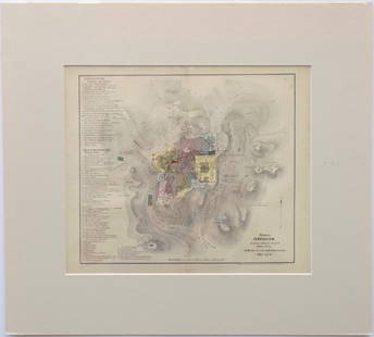
Map of Jerusalem. London, 1689 (but likely early 1700s). 21.5" x 17". On heavy laid paper. With stub along vertical crease and two other vertical creases (as once bound, folding), a few short closed tears to margins, one small stain (noticeable mostly to verso), else clean. Accompanied by disbound text fragment, in English, describing the map (pp. 129-142, folio, 17" tall). Overall clean and quite attractive.
Buyer's Premium
- 25%
[Map] Map of Jerusalem, 18th century
Estimate $80 - $120
4 bidders are watching this item.
Shipping & Pickup Options
Item located in Macon, GA, usSee Policy for Shipping
Payment

TOP