


Civil War Manuscript Map, West TN Railroads
Similar Sale History
View More Items in Militaria & War Memorabilia

![[Civil War, Bull Run, Confederate]: Book with small manuscript battlefield map of Manassas. Gilham, William. MANUAL OF INSTRUCTION FOR THE VOLUNTEERS AND MILITIA OF THE UNITED STATES. Philadelphia: Desilver, 1861. 8vo. 743, [1] pp., 7 f](https://p1.liveauctioneers.com/3532/129264/65744735_1_x.jpg?height=310&quality=70&version=1539223604)


![[CIVIL WAR]. Manuscript Printed Confederate Soldier’s Disch...: [CIVIL WAR]. Manuscript Printed Confederate Soldier’s Discharge Document. Tennessee: 1862. Printed discharge document with manuscript information for “W. H. Reid Private” Company H S](https://p1.liveauctioneers.com/928/318880/171360934_1_x.jpg?height=310&quality=70&version=1707501302)


![[Civil War; Map] History of the War [1864]: Bishop, John S., Capt.: A CONCISE HISTORY OF THE WAR. DESIGNED TO ACCOMPANY PERRINE'S NEW WAR MAP OF THE SOUTHERN STATES.... Indianapolis. [1864]. 132, xi, [1] pp. plus large folding map. 5.75" x 3.75](https://p1.liveauctioneers.com/3532/91776/46880401_1_x.jpg?height=310&quality=70&version=1469669287)


Related Militaria & War Memorabilia


![[JOHN BROWN] Mayor of Harpers Ferry Signed Document: Partly printed court summons completed in manuscript and signed by Fontaine Beckham, as sheriff. Jefferson County, Virginia, 13 May 1847. 1 page. Docketed to verso and again signed by Beckham. A court](https://p1.liveauctioneers.com/7226/322253/173251666_1_x.jpg?height=310&quality=70&version=1710004847)

![[CIVIL WAR] Sheridan's Annotated West Point Textbook: D.H. Mahan. An Elementary Treatise on Advanced-Guard, Out-Post, and Detachment Service of Troops. New York: John Wiley, 1853. 8vo. Original brown cloth. INSCRIBED BY SHERIDAN AS A CADET in ink to fron](https://p1.liveauctioneers.com/7226/325455/175168968_1_x.jpg?height=310&quality=70&version=1712370394)


![West Point Cadets, Future Confederate Officers: Half plate studio ambrotype. [ca 1859-1860]. Full thermoplastic case with rural genre vignette. With period note reading: “W.R. Jones & his friend at West Point John W. Lea/ [on reverse] who aft](https://p1.liveauctioneers.com/7226/325455/175168971_1_x.jpg?height=310&quality=70&version=1712370394)


![[Civil War Gettysburg] 107th PA ID Disc: Gilt brass "Against Rebellion" soldier's ID tag. Obverse features a patriotic shield reading "Union" with the legend "Against Rebellion / 1861." Reverse stamped "John Orth . / Co. E / 107th / Regt. /](https://p1.liveauctioneers.com/7226/325455/175169068_1_x.jpg?height=310&quality=70&version=1712370394)
More Items in Militaria & War Memorabilia
View More


![George Washington Signed Discharge: Partly printed discharge document signed by George Washington, as Commander in Chief of the Armies of the United States. Newburgh, [New York], 4 January 1783. 1 page, ## x ## in. Undersigned by Washin](https://p1.liveauctioneers.com/7226/322253/173251475_1_x.jpg?height=310&quality=70&version=1710004847)
![[Ambrotype] Texas Confederate Soldier: Sixth plate ambrotype. Full leatherette case. Portrait of a possible Texas Confederate soldier. A silver star device was used to pin up the brim of his light-toned headgear, a look often seen in image](https://p1.liveauctioneers.com/7226/322253/173251509_1_x.jpg?height=310&quality=70&version=1710004847)

![[CIVIL WAR] 1st Texas Infantry in Camp: Outdoor half plate ambrotype of the 1st Texas Infantry. Full leatherette case. Significant, large half plate ambrotype of members of the 1st Texas Infantry at ‘Splinterville,’ the regiment’s win](https://p1.liveauctioneers.com/7226/322253/173251512_1_x.jpg?height=310&quality=70&version=1710004847)
![Captured Bowie Knife w/ Period Note of Provenance: Captured Confederate D-hilt Bowie knife. [Kenansville, North Carolina]: [Louis Froelich factory]. With original metal and leather sheath with affixed period notes. First note with only remnants. Secon](https://p1.liveauctioneers.com/7226/325455/175169154_1_x.jpg?height=310&quality=70&version=1712370394)
![[HANCOCK, John] Washington’s Spy, Officer’s Commission: Partly printed document signed by John Hancock as President of the Continental Congress, for Epaphras Bull (1748-1781). [Philadelphia, Pennsylvania], 10 January 1777. 1 page, ## x ## in. Completed in](https://p1.liveauctioneers.com/7226/322253/173251471_1_x.jpg?height=310&quality=70&version=1710004847)
![[CIVIL WAR] Black Soldier & Wife: CDV-sized tintype photograph WITH gem-sized tintype. Full thermoplastic case. Portrait of an unknown African American Civil War soldier who holds the rank of sergeant. He looks directly at the camera](https://p1.liveauctioneers.com/7226/322253/173251671_1_x.jpg?height=310&quality=70&version=1710004847)
![Historic Einstein Signed Program from Lincoln University Visit: Conferences on Objectives. Lincoln University, [Oxford], Pennsylvania, 3 May 1946. SIGNED BY ALBERT EINSTEIN. Tipped into Horace Mann Bond (1904-1972). The Education of the Negro in the American Socia](https://p1.liveauctioneers.com/7226/322253/173251693_1_x.jpg?height=310&quality=70&version=1710004847)
![[Civil War] Bullet Which Nearly Killed Soldier: Lead bullet encased in gold acorn fob with chain. Finely engraved: "W.D. Fiske / 14th Regt. C V / Fredericksburg / Dec 17, 1863." Acorn approx. 1 1/2 x 1 in. Overall length 6 1/2 in. Published in "Her](https://p1.liveauctioneers.com/7226/325455/175169103_1_x.jpg?height=310&quality=70&version=1712370394)


Recommended Collectibles
View More


Item Details
Description
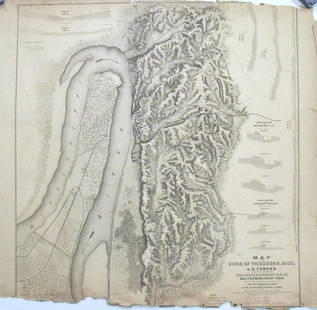
Civil War era ink on laid paper hand drawn map depicting West Tennessee and Northern Mississippi and Alabama. The strategical map focuses on towns, cities, and railroad stations and their positions along the railroads, rivers, and roads of the region. Towns, cities, and stations identified include Paris, Hainbolt, Lexington, Henderson, Bolivar, Grand Junction, McNairy, Saltillo, Cerro Gordo, Coffee, Savannah, Crump Landing, Bethel, Purdy, Adamsville, Pittsburg, Holly Springs, Corinth, Eastport, Waterloo, Iuka, Leland, Florence, and Tuscumbia. Includes a table of contents that lists five starting points from railroad stations and river towns to various regional locations with the travel distance in miles. Also includes Explanation with a key for roads and railroads, and a compass rose illustrating North and South. Pencil inscription reading "Comag Officer I_U_KA" en verso. Housed in a sealed plastic archival sleeve. Map - 7 1/2" H x 9 1/2" W. Sleeve - 8 1/4" H x 10 1/8" W. Provenance: The estate of Dr. Benjamin H. Caldwell, Nashville, Tennessee. (Additional high-resolution photos are available at www.caseantiques.com.)
Condition
Overall very good condition, possibly deacidified. Writing and illustrations in strong, highly visible condition. Tears, largest 1" x 3/4", corners and edges of lower fold lines. 1/8" tears, center of left side of map. 1/2" loss at upper left corner. Sealed in a plastic sleeve.
Buyer's Premium
- 28%
Civil War Manuscript Map, West TN Railroads
Estimate $300 - $350
10 bidders are watching this item.
Shipping & Pickup Options
Item located in Knoxville, TN, usSee Policy for Shipping
Payment
Accepts seamless payments through LiveAuctioneers

TOP