Similar Sale History
View More Items in Maps & Atlases


Item Details
Description
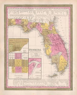
Scarce and elusive true first printing of Samuel Augustus Mitchell and H. N. Burrough’s 1846 map of North Carolina showing the state’s Gold Region in Rowan and surrounding counties. Gold has been an important part of North Carolina's history since 1799, the date of the first authenticated discovery of gold in the United States. The state was the nation's only gold-producing state from 1803 until 1828, continuing as a leading producer until 1848 when gold was discovered in California just a couple of years after this map was published. Excellent example, with insets of the Gold Region (centered on Cabarrus and Montgomery Co) and the Neuse River and New Berne. Shows towns, roads, railroads, rivers, mountains, lakes, creeks, canals, etc. Canals are noted in red and rail lines and proposed rail lines also shown. The map was first issued by Henry S. Tanner and appears in various formats until the late 1850s. Includes a table of distances and profile of the Dismal Swamp Canal. True first printing with the Carey & Hart decorative border designs that only appear on the first printing maps. Later in 1846 a second printing of the atlas had all the maps with new border designs. Couple of inconsequential spots of foxing near the title. Light toning to edges, typical of Mitchell maps of this era. A lovely, authentic antique first edition/first printing map. 11.5 x 13.75
Reserve: $210.00
Shipping:Domestic: Flat-rate of $6.00 to anywhere within the contiguous U.S. International: Foreign shipping rates are determined by destination. International shipping may be subject to VAT. Combined shipping: Please ask about combined shipping for multiple lots before bidding. Location: This item ships from Ohio
Your purchase is protected:
Photos, descriptions, and estimates were prepared with the utmost care by a fully certified expert and appraiser. All items in this sale are guaranteed authentic.
In the rare event that the item did not conform to the lot description in the sale, Jasper52 specialists are here to help. Buyers may return the item for a full refund provided you notify Jasper52 within 5 days of receiving the item.
Reserve: $210.00
Shipping:
Your purchase is protected:
Photos, descriptions, and estimates were prepared with the utmost care by a fully certified expert and appraiser. All items in this sale are guaranteed authentic.
In the rare event that the item did not conform to the lot description in the sale, Jasper52 specialists are here to help. Buyers may return the item for a full refund provided you notify Jasper52 within 5 days of receiving the item.
Condition
Very good
Buyer's Premium
- 15%
Scarce 1846 1st printing of N. Carolina map showing Gold Region
$210.00
$275
1 bidder is watching this item.
Shipping & Pickup Options
Item located in Ohio, US$6 shipping in the US
Payment
Accepts seamless payments through LiveAuctioneers
See More Items From This Jasper52 Seller

TOP


![Map & Street Directory of Hollywood, 1919: Heading: (California - Los Angeles) Author: Title: Map of Hollywood and Street Directory. Also Outline Map of Southern California Place Published: [Hollywood, California] Publisher:Hollywood National](https://p1.liveauctioneers.com/642/326037/175553802_1_x.jpg?height=310&quality=70&version=1713477451)


![Gossage, John [SIGNED]; The Thirty-Two Inch Ruler / Map of Babylon [SIGNED TWICE - FINE COPY]: SIGNED COPY Steidl, Gottingen. 2010. Hardcover in dust jacket. First edition, first printing. First book in color by Gossage. 80 pages, 180 colour plates. Essays by John Gossage and Gerhard Steidl. SI](https://p1.liveauctioneers.com/8658/325945/175540043_1_x.jpg?height=310&quality=70&version=1712964944)


