![[MAPS AND PRINTS]. DE L'ISLE, Gulliaume (1675-1726). Eight Maps of France by Gulliaume: [MAPS AND PRINTS]. DE L'ISLE, Gulliaume (1675-1726). Eight Maps of France by Gulliaume De L'Isle. Paris: De L'Isle et al., 1712-1745. Including:Carte de France. Paris: De L'Isle, 1731. Sight approxima](https://p1.liveauctioneers.com/928/421136/234320834_1_x.jpg?height=310&quality=70&version=1781294369)
No upcoming results for "de-jonge-prints"
But we've sold 10000 before. Follow this search to get notified as soon as more arrive.


You May Also Like

![[MAPS AND PRINTS]. DE L'ISLE, Gulliaume (1675-1726). Four Mediterranean Maps: [MAPS AND PRINTS]. DE L'ISLE, Gulliaume (1675-1726). Four Mediterranean Maps by Gulliaume De L'Isle. Paris: De L'Isle et al., 1700-1745. Including:L'Italie. Paris: De L'Isle, 1700. Sight approximately](https://p1.liveauctioneers.com/928/421136/234320832_1_x.jpg?height=310&quality=70&version=1781294369)
![[MAPS AND PRINTS]. DE L'ISLE, Gulliaume (1675-1726). Eight European Maps by Gulliaume De: [MAPS AND PRINTS]. DE L'ISLE, Gulliaume (1675-1726). Eight European Maps by Gulliaume De L'Isle. Paris: De L'Isle et al., 1702-1745. Including:Carte des Provinces Unies des Pays Bas. Paris: De L'Isle,](https://p1.liveauctioneers.com/928/421136/234320833_1_x.jpg?height=310&quality=70&version=1781294369)
$400
![[MAPS AND PRINTS]. DE L'ISLE, Gulliame (1675-1726). Five Ecclesiastical Maps by Gulliame: [MAPS AND PRINTS]. DE L'ISLE, Gulliaume (1675-1726). Five Ecclesiastical Maps by Gulliaume De L'Isle. Paris: De L'ilse, 1700-1707. Including:In Notitiam Ecclesiastica Africae Tabula Geographica. Paris](https://p1.liveauctioneers.com/928/421136/234320840_1_x.jpg?height=310&quality=70&version=1781294369)
$250
![[MAPS AND PRINTS].  DE L'ISLE, Gulliaume (1675-1726). L'Amerique: [MAPS AND PRINTS]. DE L'ISLE, Gulliaume (1675-1726). L'Amerique Meridionale. Paris: De L'Isle, 1708. Hand-colored engraving matted under plexi. Sight approximately 23.5 X 18.25". Frame approximately 3](https://p1.liveauctioneers.com/928/421136/234321156_1_x.jpg?height=310&quality=70&version=1781294369)
![[PHOTOGRAPHY]. [BOOTH, John Wilkes (1838-1865), subject]. C...: [PHOTOGRAPHY]. [BOOTH, John Wilkes (1838-1865), subject]. Carte de Visite of Booth. [New York: C. D. Fredericks, ca. 1860s]. Albumen carte de visite on mount, standing portrait of Booth with his right](https://p1.liveauctioneers.com/928/421136/234320893_1_x.jpg?height=310&quality=70&version=1781294369)
$400


CA$200
![Chatelain - Large Map of Pacific & Americas [Carte tres curieuse de la Mer du Sud ?]: This exceptional large format map of the Americas is entitled "Carte tres curieuse de la Mer du Sud, contenant des remarques nouvelles... mais aussy sur les principaux pays de l'Amerique... avec les n](https://p1.liveauctioneers.com/6581/422565/235192823_1_x.jpg?height=310&quality=70&version=1782302553)
$2,000
![[MAPS AND PRINTS]. [DE L'ISLE, Gulliame (1675-1726), after]. MOLL, Hermann.: [MAPS AND PRINTS]. [DE L'ISLE, Gulliame (1675-1726), after]. MOLL, Hermann. An Historical Map of the Roman Empire and the neighboring Barbarous Nations. London: Moll, 1709. Hand-colored engraving moun](https://p1.liveauctioneers.com/928/421136/234320835_1_x.jpg?height=310&quality=70&version=1781294369)

Similar Items on
Explore similar finds from our sister marketplace, Chairish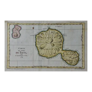

10000 past auction results for "de-jonge-prints"
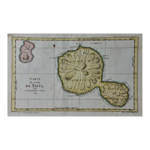
Browse a record of outcomes from past auctions, including sale prices and unsold items.![Carte de l'Isle de Taiti'. Island of Tahiti. COOK /: TITLE/CONTENT OF MAP: 'Carte de l'Isle de Taiti , par le Lieutenant J. Cook 1769 [Map of the Island of Tahiti by Lieutenant J. Cook 1769]' DATE PRINTED: 1789 IMAGE SIZE: Approx 25.0 x 41.5cm, 9.75 x 1](https://p1.liveauctioneers.com/5584/160124/80833245_1_x.jpg?height=280&quality=70&sharpen=true&version=1580249865&width=280)
Jasper52New York, NY

Jasper52New York, NY

Jasper52New York, NY

Jasper52New York, NY

Jasper52New York, NY

Jasper52New York, NY

Jasper52New York, NY

Donny Malone AuctionsSAUGERTIES, NY
![[Americana] Tocqueville, Alexis de, De la démocratie en: [Americana] Tocqueville, Alexis de De la démocratie en Amérique Paris: Librairie de Charles Gosselin, 1835. Volume two only. First edition. 8vo. (4), 459 pp. Rare original printed wrappers, lightly](https://p1.liveauctioneers.com/197/159076/80332946_1_x.jpg?height=280&quality=70&sharpen=true&version=1578427354&width=280)
Freeman'sPhiladelphia, PA

Grant Zahajko Auctions, LLCDavenport, WA

Preston Hall GalleryDallas, TX

Hess Fine AuctionsSt Petersburg, FL

Hess Fine AuctionsSt Petersburg, FL

New Orleans Auction GalleriesNew Orleans, LA

New Orleans Auction GalleriesNew Orleans, LA

AntikBar Original Vintage PostersLondon

AntikBar Original Vintage PostersLondon

AntikBar Original Vintage PostersLondon

Historia AuctionataBerlin

Albion AuctionsChesterfield

Albion AuctionsChesterfield

Albion AuctionsChesterfield

Albion AuctionsChesterfield

Albion AuctionsChesterfield
TOP