Arader Galleries' March 2018 Auction

Done
New York, NY, United States
Auction Details
Arader Galleries' March 2018 Auction
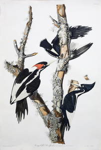
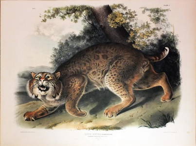
The sale features excellent examples from John James Audubon's Birds of America as well as the thirty of the best plates from his Viviparous Quadrupeds of North America. Included also is a compelling selection of natural history watercolors, maps and rare books.


![Dupont Copy of 1513 Ptolemy's Geographie: PTOLEMAEUS, Claudius (100-170 AD). Geographie opus novissima traductione e Graecorum archtypis castigatissme pressum. [Colophin:] Strassburg: Johann Schott, 1513. Guidance: Sotheby?s London, 2006 -](https://p1.liveauctioneers.com/1968/117553/60437504_1_x.jpg?height=310&quality=70&version=1520269117)


![Two Part John Pine Book of Tapestries: PINE, John (1690?1756). The procession and ceremonies observed at the time of the installation of the Knights Companions of the most Honourable Military Order of the Bath. [AND] The Tapestry Hangings](https://p1.liveauctioneers.com/1968/117553/60437507_1_x.jpg?height=310&quality=70&version=1520269117)


Auction Details

Bid Increments
PriceBid Increment
$0
$10
$100
$25
$400
$50
$1,000
$100
$2,000
$250
$10,000
$500
$25,000
$1,000
$50,000
$2,500
$100,000
$5,000
$1,000,000
$10,000
Preview
Limited preview available March 13th-26th, full preview March 28th-31st at 1016 Madison Avenue, New York.
New York, NY 10075
USA
Buyer's Premium
- 27%
Terms & Conditions
By bidding at the auction, whether present in person or by agent, or by written bid, telephone, internet or by other means, the buyer agrees to be bound by the conditions of the sale.
1. All properties are sold as is, and neither we nor the consignor make any warranties or representations with respect to any lot sold including but not limited to the correctness of the catalogue description, the physical condition, size, quality, rarity, attribution , authorship, importance, medium, provenance, exhibitions, literature or historical relevance of the property, and no statement anywhere, whether oral or written, shall be deemed such a warranty or representation. All sizes listed are approximate. Prospective bidders should inspect the property before bidding to determine condition, size, and whether or not it has been repaired or restored. WE AND THE CONSIGNOR DISCLAIM ANY AND ALL WARRANTIES, EXPRESSED OR IMPLIED, INCLUDING BUT NOT LIMITED TO THE IMPLIED WARRANTY OR MERCHANTABILITY OR FITNESS FOR ANY PARTICULAR PURPOSE. NO WARRANTIES ARE MADE THAT ANY OF THE MERCHANDISE COMPLIES WITH ANY APPLICABLE GOVERNMENTAL RULES, REGULATIONS OR GUIDELINES OF ANY KIND OR NATURE WHATSOEVER. Mid-Hudson Galleries Ltd. as agent, nor the consignor is responsible for any faults or defects in any lot or the correctness of any images or statement as to the origin, authorship, date, age, attribution, genuineness, provenance or condition of any lot.
2. A buyer's premium will be added to the purchase of all lots in the sale, and is payable by the purchaser as part of the total purchase price. The buyer?s premium for bidders participating in the auction in person or in absentia, either on the telephone or by submitting written bids in advance, is 22%. The buyer's premium for internet bidders is 25%. Mid-Hudson Galleries Ltd. may also receive a commission from the consignor.
3. We reserve the right to withdraw any property before the sale.
4. Unless otherwise announced by the auctioneer, all bids are per lot as numbered in the catalogue. The auctioneer may open bidding on any lot below the reserve by placing a bid on behalf of the seller. The auctioneer may continue to bid on behalf of the seller up to the amount of the reserve either by placing consecutive bids or by placing bids in response to other bidders.
5. All bids placed and all payments made must be in U.S. dollars drawn on a U.S. bank unless payment in U.S. dollars wired from a foreign bank has been pre-arranged.
6. We reserve the right to reject any bid. The highest bidder acknowledged by the auctioneer will be the purchaser. In the event of a dispute between bidders, or in the event of doubt on our part as to the validity of any bid, the auctioneer will have the final discretion whether to resell the article in dispute. If any dispute arises after the sale, our sale records are conclusive. Although in our discretion we will execute order bids or accept telephone bids and internet bids as a convenience to clients who are not present at the auction, we are not responsible for any errors or omissions in connection therewith.
7. If the auctioneer decides that any opening bid is below the value of the article offered, he or she may reject the same and withdraw the article from sale, and if having acknowledged an opening bid, he or she decides that any advance thereafter is insufficient, he or she may reject the advance.
8. On the fall of the auctioneer?s hammer, title to the offered lot will pass to the highest bidder acknowledged by the auctioneer subject to fulfillment by such bidder, of all the conditions set forth herein, and such bidder thereupon 1) assumes full risk and responsibility thereof, but not limited to, insurance, fire, theft, removal and storage or damage from any and all causes and b) will pay full purchase price thereof. In addition to other remedies available to us by law, we reserve the right to impose a late charge of 1 % per month of the total purchase price if payment is not made in accordance with the conditions set forth. f any applicable conditions herein are not complied with by the purchaser, in addition to other remedies available to us and the Consigner by law, haser liable for the total purchase price, we at our option may either, a) cancel the sale, retaining as liquidated damages all payments made by the purchaser, or b) resell the property at public auction without reserve, and the purchaser will be liable for any deficiency costs including handling charges, the expenses of both sales, our commissions on both sales at our regular rates, reasonable attorney?s fees, incidental damages, and all other charges due hereunder.
In the event that such a buyer pays a portion of the purchase price for any or all lots purchased, Mid-Hudson Auction Galleries shall apply the payment received to such lot or lots that Mid-Hudson Auction Galleries, in its sole discretion deems appropriate. In the case of default, purchaser shall be liable for legal fees and expenses. In addition, a defaulting purchaser will be deemed to have granted us a security interest in, and we may retain as collateral security for such purchaser?s obligations to us, any property in our possession owned by such purchaser. We shall have the rights afforded a secured party under the New York Uniform Commercial Code with respect to such property and we may apply against such obligations all monies held or received by us for the account of, due from us to, such purchaser.
9 Estimates do not represent any opinion or guarantee of actual value or ultimate sale price. Actual prices realized for items can fall below or above this range. They should not be relied upon as a prediction or guarantee of the actual selling price. They are prepared well in advance of the sale and are subject to revision.
10. Should any disputes arise pertaining to purchases at this auction or any other matters relating to the auction, such disputes shall be brought in the courts of the State of New York. Venue shall be within the County of New York.
11. Any claim regarding a purchase must be made by the successful bidder to Mid-Hudson Auction Galleries, in writing, certified mail, return receipt requested, within 90 days of the final day of the live auction. Thereafter, all claims shall be time-barred.
12. Unless exempt by law, purchasers will be required to pay NYS sales tax and other local taxes as required.
13. If bidding by internet, the purchaser shall have consented to the exclusive jurisdiction of The State of New York.
14. Packing and handling of purchased lots by us or by someone else is at the entire risk of the purchaser. Purchasers are responsible for all packing and shipping costs.
We are not responsible for the acts or omissions of carriers or packers of purchased lots whether or not recommended by us.
15. We are happy to help you on the telephone or via e-mail with condition reports or any other information you might need to facilitate your bidding.
TOP