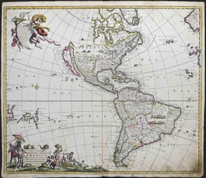
![Chatelain - Large Map of Pacific & Americas [Carte tres curieuse de la Mer du Sud ?]: This exceptional large format map of the Americas is entitled "Carte tres curieuse de la Mer du Sud, contenant des remarques nouvelles... mais aussy sur les principaux pays de l'Amerique... avec les n](https://p1.liveauctioneers.com/6581/422565/235192823_1_x.jpg?height=310&quality=70&version=1782302553)
No upcoming results for "world-map-1825"
But we've sold 3627 before. Follow this search to get notified as soon as more arrive.


You May Also Like

$1,500


$250


$500
![[MAPS AND PRINTS]. DE WIT, Frederik¬†(ca.¬†1629-1706).¬†Mare¬: [MAPS AND PRINTS]. DE WIT, Frederik (ca. 1629-1706). Mare Balticum. Nieuwe Pascaert van de Oost Zee. Amsterdam: de Wit, [ca. 1680]. Presumed first edition with later hand-coloring matted under plexi.](https://p1.liveauctioneers.com/928/421136/234320842_1_x.jpg?height=310&quality=70&version=1781294369)

![[MAPS] 1820 Harmon's "Map of the Interior of America": A Map of the Interior of North America. Engraved map. Boston: Annin & Smith, [1820]. 1 page, 18 15/16 x 7 3/4 in. FROM Daniel W. Harmon. A Journal of Voyages and Travels in the I](https://p1.liveauctioneers.com/7226/422185/235035227_1_x.jpg?height=310&quality=70&version=1781916990)
![[MAPS AND PRINTS]. DE WIT, Frederik (ca. 1629-1706). De Bocht van Vranckryck: [MAPS AND PRINTS]. DE WIT, Frederik (ca. 1629-1706). De Bocht van Vranckryck Biscajen en Galis Sen. Amsterdam: de Wit, [ca. 1690]. Presumed first edition with later hand-coloring matted under plexi. S](https://p1.liveauctioneers.com/928/421136/234320831_1_x.jpg?height=310&quality=70&version=1781294369)


Similar Items on
Explore similar finds from our sister marketplace, Chairish
3627 past auction results for "world-map-1825"
Browse a record of outcomes from past auctions, including sale prices and unsold items.
Artemis Fine ArtsLouisville, CO

Jasper52New York, NY

Jasper52New York, NY
![1898 Rand McNally Chart of World Flags -- [World Flags]: Title/Content of Map: 1898 Rand McNally Chart of World Flags -- [World Flags] Cartographer: Rand McNally Year/Place: 1898, Chicago Size: 12.5 X 9.2 in. This is a very nice chart of 60 world flags, org](https://p1.liveauctioneers.com/5584/173638/87405912_1_x.jpg?height=280&quality=70&sharpen=true&version=1594766493&width=280)
Jasper52New York, NY

Jasper52New York, NY

Jasper52New York, NY

Jasper52New York, NY

Jasper52New York, NY

Jasper52New York, NY

Jasper52New York, NY

Jasper52New York, NY

Jasper52New York, NY

South Bay AuctionsEast Moriches, NY

Forum AuctionsLondon

Jasper52New York, NY

Jasper52New York, NY

Jasper52New York, NY

Jasper52New York, NY

Jasper52New York, NY

Jasper52New York, NY

Blackwell AuctionsClearwater, FL

Case Antiques, Inc. Auctions & AppraisalsKnoxville, TN

Bodnar's Auction SalesNew Brunswick, NJ

Bodnar's Auction SalesNew Brunswick, NJ
TOP