Done
Chicago, IL, United States
Auction Details
Five Centuries of World Cartography
Hundreds of authentic, antique maps and prints offered by New World Cartographic.
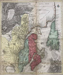
![Canada and Nova Scotia: Engineered by W. Dassauville, Edinburgh[Drawn and engraved for Thomson’s New General Atlas, 1817]48 cm x 59 cm Original color. Some light water staining in upper left and upper right corners.](https://p1.liveauctioneers.com/6940/190006/95714196_1_x.jpg?height=310&quality=70&version=1611161516)


Auction Details

Bid Increments
PriceBid Increment
$0
$10
$100
$10
$200
$20
$500
$50
$1,000
$100
$2,000
$200
$5,000
$500
$10,000
$1,000
$20,000
$2,000
$50,000
$5,000
$100,000
$500
$500,000
$500
$1,000,000
$500
$5,000,000
$500
$10,000,000
$1,000
$50,000,000
$1,000
$100,000,000
$5,000
$500,000,000
$5,000
Buyer's Premium
- 25% up to $500,000.00
- 25% above $500,000.00
Terms & Conditions
All sales made through Live Auctioneers are subject to Terms & Conditions of New World Cartographic.
Invoice will be sent by info@nwcartographic.com
TOP