![World War 2. Guadalcanal Campaign. August & September 1942 Operations 1959 map: CAPTION PRINTED BELOW PICTURE: 'The War with Japan - Guadalcanal Campaign - Operations During August and September 1942' DATE PRINTED: 1959 IMAGE SIZE: Approx 25.0 x 33.0cm, 9.75 x 13 inches (Large) T](https://p1.liveauctioneers.com/5584/332711/179480281_1_x.jpg?height=310&quality=70&version=1718142737)
![](https://p1.liveauctioneers.com/6667/334167/180576045_1_x.jpg?height=104&quality=70&version=1718993103&width=104)
![](https://p1.liveauctioneers.com/6667/334167/180576043_1_x.jpg?height=104&quality=70&version=1718993103&width=104)
![](https://p1.liveauctioneers.com/6667/334167/180576047_1_x.jpg?height=104&quality=70&version=1719266246&width=104)
![World War 2. Guadalcanal Campaign. August & September 1942 Operations 1959 map: CAPTION PRINTED BELOW PICTURE: 'The War with Japan - Guadalcanal Campaign - Operations During August and September 1942' DATE PRINTED: 1959 IMAGE SIZE: Approx 25.0 x 33.0cm, 9.75 x 13 inches (Large) T](https://p1.liveauctioneers.com/5584/332711/179480281_1_x.jpg?height=310&quality=70&version=1718142737)
![1834 Malte-Brun Map of Russia in Europe -- Russia in Europe: Title: 1834 Malte-Brun Map of Russia in Europe -- Russia in Europe Cartographer: M. Malte-Brun / S. Walker Year / Place: 1834, Boston Map Dimension (in.): 9.3 x 7.5 in. An attractive and highly detail](https://p1.liveauctioneers.com/5584/332709/179478830_1_x.jpg?height=310&quality=70&version=1718142738)
![1875, United Kingdom and Ireland by Hardesty: Title: 1875, United Kingdom and Ireland by Hardesty Date/Period: 1875 Materials: Hand color, steel engraving Size: 19 1/2 x 26” 1875 map from H.H. Hardesty's 'Historical Atlas of the World Illus](https://p1.liveauctioneers.com/5584/331526/178834573_1_x.jpg?height=310&quality=70&version=1717530687)
![1834 Malte-Brun Map of Germany -- Germany Divided into Circles: Title: 1834 Malte-Brun Map of Germany -- Germany Divided into Circles Cartographer: M. Malte-Brun / S. Walker Year / Place: 1834, Boston Map Dimension (in.): 9.3 x 7.5 in. An attractive and highly det](https://p1.liveauctioneers.com/5584/332709/179479011_1_x.jpg?height=310&quality=70&version=1718142738)
![1834 Malte-Brun Map of the Netherlands -- The Seven United Provinces with their Dependencies: Title: 1834 Malte-Brun Map of the Netherlands -- The Seven United Provinces with their Dependencies Cartographer: M. Malte-Brun / S. Walker Year / Place: 1834, Boston Map Dimension (in.): 9.3 x 7.5 in](https://p1.liveauctioneers.com/5584/332709/179478831_1_x.jpg?height=310&quality=70&version=1718142738)
![Provinz Pommern.: Title: Provinz Pommern. Publication Date: c1847 Cartographer: F. Handtke Publisher: C. FLEMMING Height: 11.6 Width: 15.8 Divided between Germany and Poland, Pomerania was strongly affected by 20th cen](https://p1.liveauctioneers.com/5584/332709/179478884_1_x.jpg?height=310&quality=70&version=1718142738)
![Soil Map Georgia Cobb Co. Sheet: Title: Soil Map Georgia Cobb Co. Sheet Publication Date: 1901 Cartographer: BURKE, R.T. AVON/H.W. MAREAN Publisher: U.S. DEPT. OF AGRICULTURE. BUREAU OF SOILS Height: 22 Width: 22.1 Handsomely chromol](https://p1.liveauctioneers.com/5584/332709/179479039_1_x.jpg?height=310&quality=70&version=1718142738)
![1767 London Magazine Map of "Billigsgate Ward and Bridge Ward within?": Title: 1767 London Magazine Map of "Billigsgate Ward and Bridge Ward within?" Cartographer: London Magazine Year / Place: 1767 c., London Map Dimension (in.): 9.5 X 14.2 in. This is an excellent and h](https://p1.liveauctioneers.com/5584/331526/178834544_1_x.jpg?height=310&quality=70&version=1717530687)
![1863 Johnson's World on Mercator's Projection: Title: 1863 Johnson's World on Mercator's Projection Cartographer: Johnson and Ward Year / Place: 1863, New York Map Dimension (in.): 16.2 X 22.5 in. This is a highly detailed double-page map of the W](https://p1.liveauctioneers.com/5584/331526/178834498_1_x.jpg?height=310&quality=70&version=1717530687)
![Large Map of Hawaiian Islands & Porto Rico: Large Map of Porto Rico With map of Hawaii - Hawaiian Islands and Samoa [separately] on versos] Cartographer: George Franklin Cram Dated: Circa 1900 Type: Color Lithograph](https://p1.liveauctioneers.com/5614/330257/178045318_1_x.jpg?height=310&quality=70&version=1716032806)
![Large Map of Texas (Western Part): Large Map of Texas (Western Part) With map of Louisiana and Arkansas [separately] on versos Cartographer: George Franklin Cram Dated: Circa 1900 Type: Color Lithograph Dime](https://p1.liveauctioneers.com/5614/330257/178045313_1_x.jpg?height=310&quality=70&version=1716032806)
![Large Map of Kentucky and Tennessee: Large Map of Kentucky and Tennessee With map of North Dakota and South Dakota [separately] on versos Cartographer: George Franklin Cram Dated: Circa 1900 Type: Color Lithograph](https://p1.liveauctioneers.com/5614/330257/178045311_1_x.jpg?height=310&quality=70&version=1716032806)
![Marianas April-July 1944. World War 2. Saipan Guam. Pacific Ocean 1961 old map: TITLE/CONTENT OF MAP: 'The Marianas' DATE PRINTED: 1961 IMAGE SIZE: Approx 21.0 x 15.0cm, 8.25 x 6 inches (Medium) TYPE: Vintage military history map CONDITION: Fair: Verso text apparent. The image sh](https://p1.liveauctioneers.com/5584/332711/179480185_1_x.jpg?height=310&quality=70&version=1718142737)
![MICRONESIA. Bubelthuap. physical. WW2 ROYAL NAVY INTELLIGENCE MAP 1944 old: TITLE/CONTENT OF MAP: 'Bubelthuap: physical' DATE PRINTED: 1944 IMAGE SIZE: Approx 17.0 x 10.5cm, 6.75 x 4 inches (Small) TYPE: Vintage Second World War British Naval Intelligence colour map CONDITION](https://p1.liveauctioneers.com/5584/332711/179480112_1_x.jpg?height=310&quality=70&version=1718142737)
![Antique Felix Delamarche Vaugondy Mappemonde Double hemisphere world map 1838: Charles-Francois Delamarche (1740-1817), the founder of the family firm was one of the most important French geographers and mapmakers of the second half of the eighteenth century. Successor to Nicola](https://p1.liveauctioneers.com/5584/332833/179634801_1_x.jpg?height=310&quality=70&version=1718167314)
![Puzzle box with wood cubs with maps of the worlds atlas 1890 french: Cartographical Cube toy 1889 Maison jullien (J L) Antique Map Charles Verneau Appealing cartographical toy, consisting of 20 wooden cubes, each side of each cube with a map section pasted on, thus for](https://p1.liveauctioneers.com/5584/332833/179634956_1_x.jpg?height=310&quality=70&version=1718167314)
![Map of All World Hemispheres 1830: Map of Western - Eastern - Southern and Northern Hemisphers - It's Islands and Coasts Hand Colored Map. Mercator Maps. Cartographer: E. Huntington Publisher H & F J Huntington Dated:](https://p1.liveauctioneers.com/5614/330257/178045398_1_x.jpg?height=310&quality=70&version=1716032806)
![Large Map of California: Large Map of California With map of Arizona and Nevada [separately] on versos Cartographer: George Franklin Cram Dated: Circa 1900 Type: Color Lithograph Dimensions: 14](https://p1.liveauctioneers.com/5614/330257/178045314_1_x.jpg?height=310&quality=70&version=1716032806)
![Large Map of Colorado & Minnesota: Map of Colorado With map of Minnesota on verso Cartographer: George Franklin Cram Dated: Circa 1900 Type: Color Lithograph Dimensions: 14 1/2 x 11" Notes & Litera](https://p1.liveauctioneers.com/5614/330257/178045310_1_x.jpg?height=310&quality=70&version=1716032806)
![MAPPEMONDE par A. Vuillemin. Decorative World map in Hemispheres 1856 old: CAPTION PRINTED BELOW PICTURE: 'Mappemonde' DATE PRINTED: 1856 IMAGE SIZE: Approx 74.5 x 53.0cm, 29.5 x 20.75 inches (Large); Please note that this is a folding map. TYPE: Antique steel engraved map w](https://p1.liveauctioneers.com/5584/332390/179263255_1_x.jpg?height=310&quality=70&version=1717528223)
![The geography of the great solar eclipse of July 14th 1748. SMITH G 1748 map: CAPTION PRINTED BELOW PICTURE: 'The geography of the great solar eclipse of July, 14, 1748 exhibiting an accurate map of all parts of the earth in which it will be visible, with the North Pole accordi](https://p1.liveauctioneers.com/5584/332390/179262960_1_x.jpg?height=310&quality=70&version=1717528223)
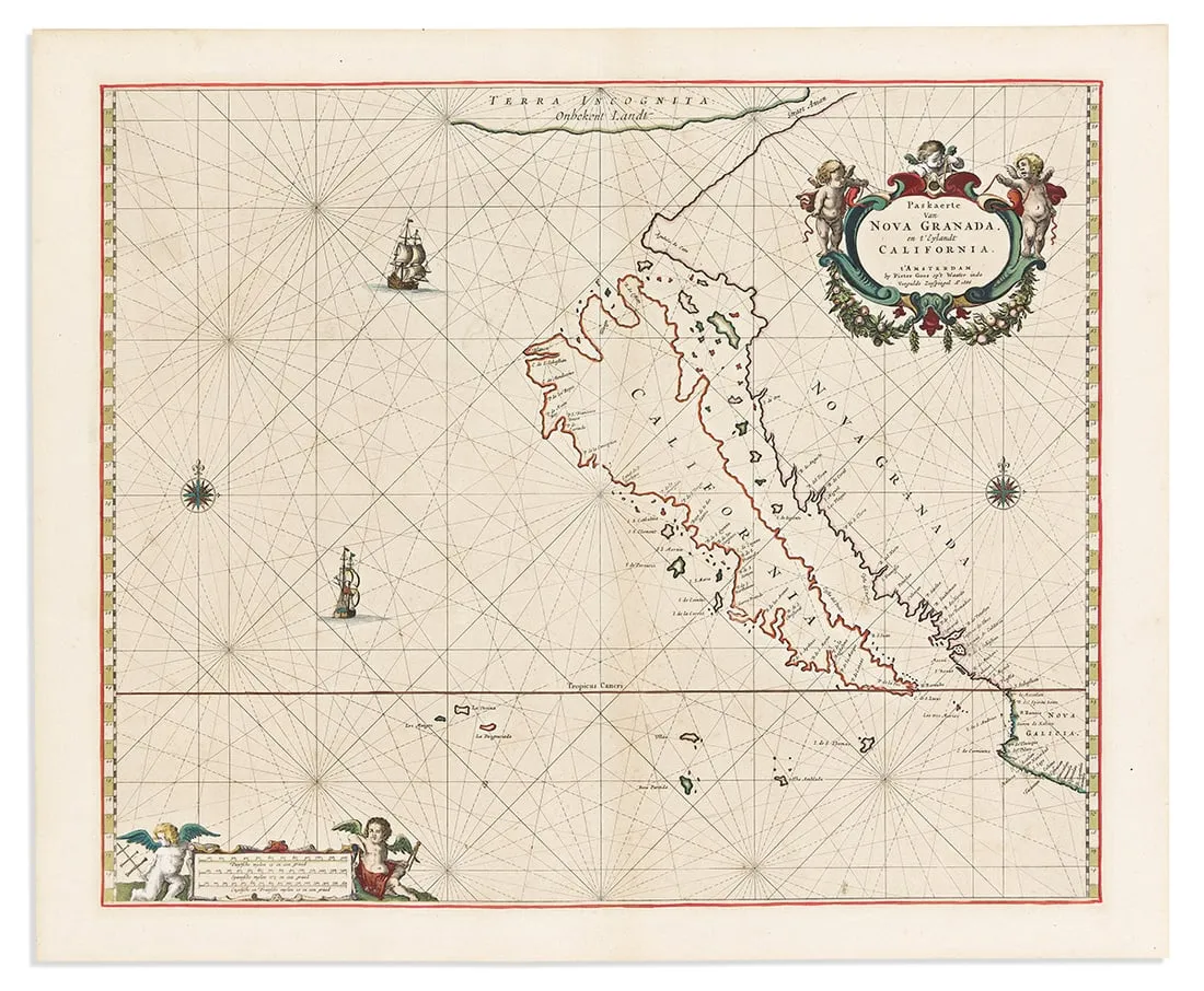
![Discorso Intorno alla carta da navigare. PORCACCHI. World navigational map 1590: CAPTION PRINTED BELOW PICTURE: Discorso Intorno alla carta da navigare [Navigational chart of the World] DATE PRINTED: 1590 IMAGE SIZE: Approx 20.5 x 29.5cm, 8.25 x 11.75 inches (Medium) TYPE: Antique](https://p1.liveauctioneers.com/5584/332390/179263132_1_x.jpg?height=310&quality=70&version=1717528223)
![The Battle of Arras - Spring 1917 Map: The Battle of Arras - Spring 1917 World War I One. Linen backed. Map 3 - Ordnance Survey - Large Map with Scale Publisher British Dated: 1919 Type: Colored Miltary Movements](https://p1.liveauctioneers.com/5614/330257/178041413_1_x.jpg?height=310&quality=70&version=1716032806)
![The German Offensive on the Lys - April 1918 Map: The German Offensive on the Lys - April 1918 World War I One. Linen backed. Map 7 - Ordnance Survey - Large Map with Scale Publisher British Dated: 1919 Type: Colored Miltary Moveme](https://p1.liveauctioneers.com/5614/330257/178041411_1_x.jpg?height=310&quality=70&version=1716032806)
News about Sports Memorabilia
![Historic maps and atlases chart course to Swann Dec. 7](https://www.liveauctioneers.com/news/wp-content/uploads/2023/11/165833907_1_x.webp)
Historic maps and atlases chart course to Swann Dec. 7
[av_heading heading=’Historic maps and atlases chart course to Swann Dec. 7′ tag=’h1′ style=” subheading_active=” show_icon=” icon=’ue800′ font=’entypo-fontello’ size=” av-desktop-font-size-title=” av-medium-font-size-title=” av-small-font-size-title=” av-mini-font-size-title=” subheading_size=” av-desktop-font-size=” av-medium-font-size=” av-small-font-size=” av-mini-font-size=” icon_size=” av-desktop-font-size-1=” av-medium-font-size-1=” av-small-font-size-1=” av-mini-font-size-1=” color=” custom_font=” subheading_color=” seperator_color=” icon_color=” margin=’,,35px,’ av-desktop-margin=” av-desktop-margin_sync=’true’ av-medium-margin=” av-medium-margin_sync=’true’ av-small-margin=’,,20px,’ av-mini-margin=” av-mini-margin_sync=’true’ headline_padding=” headline_padding_sync=’true’ av-desktop-headline_padding=” av-desktop-headline_padding_sync=’true’ av-medium-headline_padding=” av-medium-headline_padding_sync=’true’ av-small-headline_padding=” av-small-headline_padding_sync=’true’ av-mini-headline_padding=” av-mini-headline_padding_sync=’true’ […]
![Celebration of Scottish engineering on display at Lyon & Turnbull Feb. 7](https://www.liveauctioneers.com/news/wp-content/uploads/2024/01/Screenshot-2024-01-25-at-9.14.33 AM.png)
Celebration of Scottish engineering on display at Lyon & Turnbull Feb. 7
EDINBURGH – A cache of material from a well-known Scottish engineering dynasty will be offered at Lyon & Turnbull. The Rare Books, Manuscripts, Maps & Photographs auction on Wednesday, February 7 includes 50 lots from the Stevenson family – designers across four generations of many of the U.K.’s lighthouses. Absentee and Internet live bidding will […]
![Dickens & Twain set world records at Potter & Potter Aug. 28](https://www.liveauctioneers.com/news/wp-content/uploads/2021/09/395-1.jpg)
Dickens & Twain set world records at Potter & Potter Aug. 28
CHICAGO – Potter and Potter‘s spectacular August 28 Fine Books and Manuscripts Sale was the company’s highest-grossing auction to date. After a day of spirited bidding, 107 lots realized between $1,000-4,999; 22 lots realized between $5,000-9,999; and 16 lots broke the five digit mark.
![Jasper52 vintage map auction Nov. 5 going global](https://www.liveauctioneers.com/news/wp-content/uploads/2019/10/77325761_3_x.jpg)
Jasper52 vintage map auction Nov. 5 going global
NEW YORK – A 19th century French terrestrial globe tops an auction of vintage maps that will be conducted by Jasper52 on Tuesday, Nov. 5. Fifteen globes and more than 130 maps and atlases are offered in the online auction. Bid absentee or live online exclusively through LiveAuctioneers.