Sold2021Charleston South Carolina mapCharleston South Carolina map surveyed by Charles Vignoles & Henry Ravenel 1820 I proved for mills atlas 38 inches x 35 inchesSee Sold Price
Sold20231841 CHARLESTON, SOUTH CAROLINA HARBOR MAP1841 CHARLESTON, SOUTH CAROLINA HARBOR MAP, lithograph on paper, "Reduced from the Original Survey / of / Major H. Bache U.S.T.E." Housed under glass in a modern frame. 1841. 8" xSee Sold Price
Sold20192 Hand Colored Maps - Georgia & South CarolinaTwo Gray's Atlas Maps on one sheet - Georgia and South Carolina Inset of Charleston on South Carolina map. Depicts railroad lines, common roads, canals, topography,See Sold Price
Sold20221872 Bird's Eye View of Charleston South Carolina Vintage Style City Map1872 Bird's Eye View of Charleston South Carolina Vintage Style City Map This great vintage style Panoramic City Map of Charleston, SC shows a bird’s eye view as it looked in the late 19thSee Sold Price
Sold2018Pre Civil War South Carolina Map Charleston 1847Original hand colored map in overall good condition. Not a repro or restrike. Recently matted and framed using conservation materials. Framed dimensions 23 x 19 inches.See Sold Price
Sold20191807 Map Charleston, South CarolinaPublished Philadelphia by C.P. Wayne. The piece titled ÒPlan of the Siege of Charleston in S. CarolinaÓ. Sight size: H10" W15" (without frame)See Sold Price
Sold2023Bellin - Map of Charleston, South CarolinaThis detailed map is from Jacques-Nicolas Bellin's Le Petit Atlas Maritime.... This first edition work was published in Paris by Bellin in 1764. The atlas had included plenty of new material as well aSee Sold Price
Sold2022ICHNOGRAPHY MAP OF CHARLESTON SCIchnography Map of Charleston, South-Carolina, at the request of Adam Tunno, Esq., for the use of the Phœnix Fire-Company of London, taken from actual survey, 2d August 1788. Professionally framedSee Sold Price
Sold2017Meyer: Antique Map of South Carolina & Charleston, 1852Map: Neueste Karte von Sud Carolina Cartographer: Bibliographischen Instituts. Place & Date: Hildburghausen / 1852 Size: 14 5/8" x 11 3/4" Condition: original color; overall age toning The beautifullySee Sold Price
Sold20211856 COLTON MAP CHARLESTON SCMap is from Colton's Atlas Of The World published by J.H. Colton And Company, 1856. Map was of Charleston, South Carolina and Savannah, Georgia. Framed with only Charleston showing. Professionally fraSee Sold Price
Sold20211855 MAP THE CITY OF CHARLESTON, SOUTH CAROLINAMap of the City of Charleston, South Carolina , published by JH Colton & Co, New York in 1855. Good condition. Paper size 11 1/2"x7". Professionally framed and matted. In frame 11 1/2"x15 1/2"x1". WeiSee Sold Price
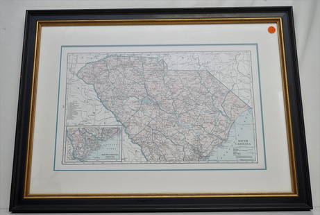
Sold2022Antique South Carolina Map with Plan of CharlestonMid to late 19th century (1850-1890). Perhaps a little older. Matted size is 21 x 14 inches.See Sold Price
Sold20191867 NORTH + SOUTH CAROLINA MAPOriginal antique map of North and South Carolina published by S. Augustus Mitchell, Jr. Includes inset maps of Charleston Harbor in the bottom left and a Plan of Charleston in the bottom right. It feaSee Sold Price
2021Savannah, Georgia & Charleston, South Carolina antiqueTITLE OF MAP (NOT PRINTED ON THE PAGE):'Colton's the City of Savannah, Georgia and the City of Charleston, South Carolina' The top image on the right hand side shows the entire map. To view a close upSee Sold Price
Sold2022Rare map Siege of Charleston in Amer. Rev. War, Marshall 1832Rare plan of the Revolutionary War Siege of Charleston in South Carolina. From John Marshall’s 1832 edition of the Life of Washington. Covers the area comprising Charleston Harbor and parts of the CSee Sold Price
Sold2022ANTIQUE MAPS, 3 PCS, H 6.25"-14.75", CHARLESTON, SAVANNAH & YORKSHIREANTIQUE MAPS, 3 PCS, H 6.25"-14.75", CHARLESTON, SAVANNAH & YORKSHIRE A selection of three antique maps. Includes one hand-colored 'Parts of North and South Carolina' coastal map (H 14.75" x W 13"), oSee Sold Price
Sold20211779 NEW AND ACCURATE MAP OF SOUTH CAROLINAA New And Accurate Map Of The Province Of South Carolina In North America. London: Universal Magazine, c. 1779. Good, showing folds, 2 small tears to edges. Narrow margins. The map shows trails and paSee Sold Price
Sold202119th c. NEW MAP OF SOUTH CAROLINARare 19th c. A New Map of South Carolina with its Canals, Roads & Distances from place to place along the Stage & Steam Boat Routes. By H.S. Tanner c. 1841-1845. Fine example of Tanner's map of SouthSee Sold Price
Sold2021HAMMONDS COMPLETE MAP OF SOUTH CAROLINAVintage Hammonds Complete Map of South Carolina. Showing all the railroad routes. c. 1930s. Professionally framed and matted. In frame measures 26 3/4"x20"x 1 1/4". Weight 7 pds. PROVENANCE: A PrivateSee Sold Price
Sold2018Meyer: South Carolina with Charleston InsetReserve Reduced! The beautifully detailed and colored map of South Carolina "with its canals, streets, steamship routes and distances between main towns" from the 1845 edition of Meyer's Hand-Atlas. ISee Sold Price
Sold20202 antique framed Southern maps2 antique framed maps: Map of South Carolina in German dated 1845. Map of Savannah and Charleston published by G.W and C.B Colton & Co and dated 1855. Overall size measures 25 1/2"h x 28"w and the papSee Sold Price
Sold2016Map of North & South Carolina, 1868Original engraving from Johnson's Atlas of the World, 1868. Map includes vignette of the Charleston Harbor & details cities, towns and territories. Dimensions: 18" x 26". This item ships from Ocean ViSee Sold Price
Sold20211861 MAP OF COAST OF SOUTH CAROLINAOriginal 1861 Frank Leslies Illustrated News Coast of South Carolina Wood Engraving with later hand coloring. Professionally framed. In frame measures 28"x31"x1". Weight 9 pds. NO IN HOUSE SHIPPING. PSee Sold Price
Sold2023Maps of North/South Carolina, Charleston HarborMap of North and South Carolina engraved and printed by Ferrier Sears & Co., published by J.T. Hinton, Simpkin & Marshall, 1832..Charleston Harbor Map, engraved for The American Coast Pilot, 14th editSee Sold Price
Jun 23Schilb Antiquarian Rare Books1863 1ed Civil War Official Confederate Battle Reports CSA Manassas CharlestonUS$395(6 bids)
JG Autographs1897 South Carolina Payment Document to Joseph Perry as Witness in the Case of Wm. Fraser vs. StateUS$25
1 day LeftJasper521775-1780 North & South Carolina, Georgia and Virginia. By Bonne & RaynalUS$180(2 bids)
5 days LeftEarly American History Auctions1864 Civil War Confederate Navy Commodore Duncan N. Ingraham ALS, Commandeers a Charleston Building!US$450
Jun 13Swann Auction Galleries(AMERICAN SOUTHEAST.) Willem Blaeu. Virginiae Partis Australis, et Floridae Partis Orientalis.US$375
5 days LeftTony Putty Artifacts7 7/8" Copper Breast Plate. South Carolina. Ex Ray Franks and Gilbert Cooper.US$50(1 bid)
17 hrs LeftToomey & Co. AuctioneersFrank Lloyd Wright, Architectural element from the Auldbrass Plantation, Yemassee, South CarolinaUS$500
P.A.C.C. Auction Gallery LLCArrowheads Frame of 7 points from South Carolina Burkheim collection largest 2"US$27(20 bids)
5 days LeftEarly American History Auctions1787 Patriot JOHN JULIUS PRINGLE as South Carolina Assembly Speaker, Travel ReimbursementUS$850
5 days LeftPotter & Potter Auctions“Okito” Money Maker. South Carolina: Algonquin McDuff (Rhett Bryson), ca. ...US$125