Sold2021Student Workbook: Maps, Charts, and Aerial Photos:SKU #: 030930 Title: Student Workbook: Maps, Charts, and Aerial Photos: Preflight (Restricted) Description: This is a Student Workbook marked "Restricted" published by the Army Air Forces Training ComSee Sold Price
Sold2018Aerodromes - Their Location & DesignAerodromes Their Location Operation and Design - Translated from the German - Extremely Rare Illustrations Maps Charts Photos Dated: 1938See Sold Price
Sold2016AE Hall Great War Illustrated Photos Maps Charts 1History And Rhymes Of Lost Battalion Beck Pvt. McCollum, Stories Of Americans in World War Charles Merrill Co. Publisher William Allen. 3 PiecesSee Sold Price
Sold2023Vintage Hawaii Aerial Pilot Chart Maps & Aircraft Cockpit Panel Layout Document LotVintage Hawaii Aerial Pilot Chart Maps & Aircraft Cockpit Panel Layout Document Lot. You will receive the following items: Aircraft Cockpit Instrument Panel (approximate size: 40 x 51 inches), 1975 TaSee Sold Price
Sold2020Scarce 1937 Map of Nantucket IslandScarce 1937 Map of Nantucket Island, from aerial survey made by, "The New England Cartographers, Inc.", with inset photo at Allen's Lobster Grill" 11 ¾ in. x 26 ½ in. Overall 15 ½ in. x 30 ½ in.See Sold Price
Sold2022Early Aerial Photos of Iranian ArcheologyHeading: Author: Schmidt, Erich Friedrich Title: Five large aerial photographs of Iranian archeological sites Place Published: Iran Publisher: Date Published: [c.1935-1937] DescriptionSee Sold Price
Sold2023TWO MARTHA'S VINEYARD MAPS/CHARTS 19th Century 28.5” x 20.5” and 18.5” x 14”TWO MARTHA'S VINEYARD MAPS/CHARTS19th Century“Muskeget Channel” and “Edgartown Harbor”.28.5” x 20.5” and 18.5” x 14”. Framed 31” x 23” and 2See Sold Price
Sold2022Aerial photo of Los Angeles County oil field c.1920Heading: (California - Los Angeles) Author: Cross, photographer Title: Santa Fe Springs Oil District Place Published: Los Angeles Publisher:Cross Date Published: c.1920 Description:See Sold Price
Sold2022LARGE ARCHITECTS PRINT / MAP / CHART CABINETFantastic very large Architectural draftsman/chart/map/print flat file - George III-Style mahogany with satinwood inlay, inset tooled leather top. 8 Drawer over 4 drawer. from the Audubon Gallery, KinSee Sold Price
Sold20212 Antique 19thC. Leather Family Bibles 1825Lot of two antique Bibles. With ornate gold embossed details on spine, gorgeous marbled endpapers. Marked Family Bibles of previous owners. Includes maps, charts, and etchings. Publisher: BrattleboroSee Sold Price
Sold2024NW Coast of America & NE Coast of Asia… ROBERTS / DELAROCHETTE. Pacific 1794 mapTITLE/CONTENT OF MAP: 'Chart of the N.W.Coast of America and the N.E. Coast of Asia explored in the years 1778 and 1779 prepared by Lieut. Henry Robert under the immediate inspection of Capt. Cook' DASee Sold Price
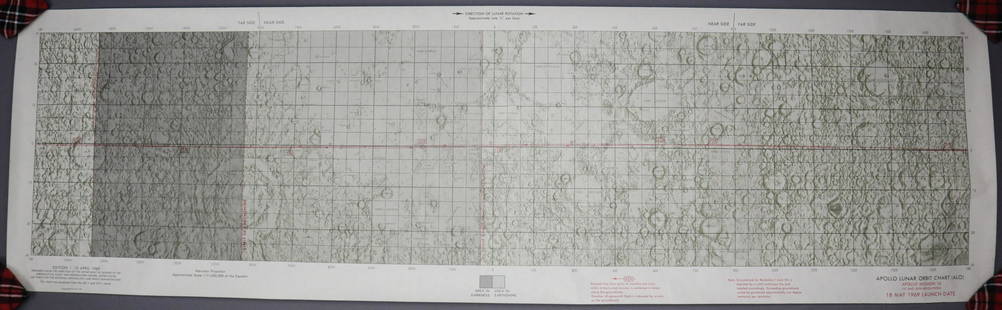
Sold2023Apollo 10 Lunar Orbit ChartThis item is from the personal collection of Grumman Test Astronaut Glennon Kingsley. This original Apollo 10 Lunar Orbit Chart is dated 10 April 1969 for the 18 May 1969 Launch Date. This map chart sSee Sold Price
Sold20241766 Emanuel Bowen "The Maps And Charts Of The Modern Part Of The Universal History"Printed for T. Osborne, A. Millar, J Rivington, B. Law And Co., T. Longman, C. Ware, and S. BladonSee Sold Price
Sold2023L'Africa. DE ROSSI / SANSON 1677 old antique vintage map plan chartTITLE/CONTENT OF MAP: L'Africa [Africa] DATE PRINTED: 1677 IMAGE SIZE: Approx 42.5 x 57.0cm, 16.75 x 22.25 inches (Large) TYPE: Antique 17th century folio atlas map CONDITION: Good; suitable for framiSee Sold Price
Sold2022Aldro T. Hibbard Personal Materials, EphemeraPersonal material belonging to Aldro T. Hibbard (1886-1972), including family bible, slides of his paintings, photos, maps, etc.See Sold Price
Sold202370304: A Marshall Islands Navigation Map Micronesia, 1A Marshall Islands Navigation Map Micronesia, 19th century Constructed of coconut palm leaf midribs and shells. Such maps or charts were for navigating specific atolls and islands in MicrSee Sold Price
Sold2017STEAM BOAT PAPER/LETTERHEAD, TRAVEL CHARTS/MAPSBOX LOT ASSORTED STEAM BOAT PAPER/LETTERHEAD, TRAVEL CHARTS/MAPS, BROADSIDE WALTER BRETT, 1869See Sold Price
Sold2020CHURCHILL, Winston (1874-1965). Second World War.CHURCHILL, Winston (1874-1965). Second World War. London: Cassell & Co., Ltd., 1948-1954. 6 volumes, 8vo (203 x 135 mm). Numerous maps and charts. Contemporary blue morocco gilt, turn-ins gilt, edgesSee Sold Price
Sold2020Early Hand Colored Map North America by T ConderAntique framed hand colored early map of North America. Top left image of Native man and foliage, reads "North America agreeable to the most approved Maps and Charts, by Thomas Condor" Frame: 14 3/4 iSee Sold Price
Sold2022(AMERICAN SOUTHWEST). William H. Emory. Report on the United States and Mexican Boundary Survey.(AMERICAN SOUTHWEST). William H. Emory. Report on the United States and Mexican Boundary Survey. 5 lithographed maps and charts (four folding, one hand-colored), 12 color-tinted lithographed plates, aSee Sold Price
Sold2023The Second World War, Six Volumesby Winston Churchill, London: Cassell & Co., Ltd., 1948-1954, six volumes (complete), with numerous charts, maps, and diagrams, some folding, bound in half tan and brown leather, gilt lettering and deSee Sold Price
Sold2023(AVIATION -- AERONAUTICAL PLANNING CHARTS.) U.S. Coast and Geodetic Survey; and others. Group of(AVIATION -- AERONAUTICAL PLANNING CHARTS.) U.S. Coast and Geodetic Survey; and others. Group of approximately 20 mid-twentieth-century American government maps and charts. Various sizes; original folSee Sold Price
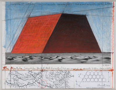
Sold2016CHRISTO & JEANNE-CLAUDE: "ABU DHABI MASTABA""ABU DHABI MASTABA (PROJECT FOR UNITED ARAB EMIRATES)"circa 2010 pencil, charcoal, oil stick, collaged aerial map and photograph on board signed and dated verso Provenance: The Estate of David Copley,See Sold Price
Sold2018Banksy original Dismaland Canvas, SignedORIGINAL BANKSY DISMALAND ART WORK ON CANVAS WITH MAP, TICKET, PHOTOS.ON REVERSE OF CANVAS THERE IS A DISMALAND LOGO HAND SPRAYED.TITILE: FLOWER THROWER (love is in the air).Size: w 30.4cm x h 40.6cm,See Sold Price
2 days LeftHolabird Western Americana CollectionsBritish Plantation Map of the Americas [179303]US$200
Jun 28Rail & Road AuctionsDiverse Group of Railroad Paper and Photos - Early 1900s N&W Telegrams, W&LE Photos and Yard Maps,US$30
Jun 27Rail & Road Auctions54 Pieces of Pennsylvania Railroad Ephemera - Pocket Calendars, Maps, Aluminum Coins, etcUS$20(1 bid)
7 days LeftLeland LittleNikolai Nikolayevich Volodimirov (Russian, 1910-2006), Suburb of LeningradUS$50(1 bid)
2 days LeftAUTOMOBILIA LADENBURG AUCTIONALFA ROMEO big mixed lot, collection of sales brochures / press kits c. 70-2000s, with more than 150€200
2 days LeftHolabird Western Americana CollectionsMeteorological Chart of the Earth c1845 (2) [180794]US$100


![Early Aerial Photos of Iranian Archeology: Heading: Author: Schmidt, Erich Friedrich Title: Five large aerial photographs of Iranian archeological sites Place Published: Iran Publisher: Date Published: [c.1935-1937] Description](https://p1.liveauctioneers.com/642/258705/134603072_1_x.jpg?height=310&quality=70&version=1661362286)


![L'Africa. DE ROSSI / SANSON 1677 old antique vintage map plan chart: TITLE/CONTENT OF MAP: L'Africa [Africa] DATE PRINTED: 1677 IMAGE SIZE: Approx 42.5 x 57.0cm, 16.75 x 22.25 inches (Large) TYPE: Antique 17th century folio atlas map CONDITION: Good; suitable for frami](https://p1.liveauctioneers.com/5584/308981/165185503_1_x.jpg?height=310&quality=70&version=1699996168)


![British Plantation Map of the Americas [179303] (1 of 1)](https://p1.liveauctioneers.com/2699/331495/178785748_1_x.jpg?height=282&quality=70&version=1717094933)


![Recon of the Black Hills 1875 [182812] (1 of 6)](https://p1.liveauctioneers.com/2699/331494/178785456_1_x.jpg?height=282&quality=70&version=1717094654)


![Meteorological Chart of the Earth c1845 (2) [180794] (1 of 3)](https://p1.liveauctioneers.com/2699/331495/178785749_1_x.jpg?height=282&quality=70&version=1717094933)