Sold2021Caribbean with Florida, gulf coast and Central America.Title: Caribbean with Florida, gulf coast and Central America. By Bonne/ Raynal Date/Period: 1780 Materials: Copperplate engraved Size: 13 1/2 x 9 3/4'' Besides showing the islands of the Caribbean, tSee Sold Price
Sold2022Florida, gulf coast, Caribbean, Central America. 1780,Title: Florida, gulf coast, Caribbean, Central America. 1780, by J. de la Porte. Paris Date/Period: 1780 Materials: Hand colored copper plate engraved Size: 9x7'' Florida depicted as a archipelago isSee Sold Price
Sold2017Bonne: Les Isles Antilles et le Golfe du Méxique, 1780Title/Content of Map: 'Les Isles Antilles et le Golfe du Méxique' A map of the Caribbean, The Gulf of Mexico, Florida & Central America This map is folding hence the centrefold line may show on the iSee Sold Price
Sold2020Central America Caribbean Gulf of Mexico chart PortsTITLE/CONTENT OF MAP: 'Central American and West Indian Ports; Inset The Pacific Coast from San Diego to Vancouver; San Francisco; Aleutian; The Pacific Coast from Seattle to Dutch Harbor; Bermudas; KSee Sold Price
Sold2022Caribbean with Florida and Central America, 1780/81 scarce map by J. B. NolinTitle: Caribbean with Florida and Central America, 1780/81 scarce map by J. B. Nolin Date/Period: 1780/ 1781 Materials: Hand colored copper plate engraved Size: 14 1/2 x 10 1/4" One of the most unusuaSee Sold Price
Sold2018Russell: Florida, Caribbean, Central AmericaA handsome folding map of the Caribbean Islands, Florida and Central America, with excellent nautical details, interesting topography, and a beautifully simple, neoclassical cartouche.; G2895; J. RussSee Sold Price
Sold2022Mexico, Central America, Caribbean, Florida and lower United States, 1794 by Vaugondy/ DelamarcheTitle: Mexico, Central America, Caribbean, Florida and lower United States, 1794 by Vaugondy/ Delamarche Date/Period: 1794 Materials: Hand colored copper plate engraved Size: 16 x 11 1/2" InterestingSee Sold Price
Sold2024Central America Caribbean Gulf of Mexico chart Ports lighthouses LARGE 1952 mapTITLE/CONTENT OF MAP: 'Central American and West Indian Ports inset The Lesser Antilles; The Windward Passage; Bermudas; Kingston; Havana; Salina Cruz; Coatzacoalcos; Willemstad, Curacao' DATE PRINTEDSee Sold Price
Sold2024Central America Caribbean Gulf of Mexico chart Ports lighthouses LARGE 1927 mapTITLE/CONTENT OF MAP: Central American and West Indian Ports [inset The Lesser Antilles; The Windward Passage; Bermudas; Kingston; Havana; Salina Cruz; Puerto Mexico; Mouths of the Mississippi] DATE PSee Sold Price
Sold2020Homann Heirs Map of the West Indies and Mexico 17Homann Heirs, "Mappa Geographica complectens I. Indiae Occidentalis Partem Mediam Circum Isthmum Panamensem," Nuremberg, 1740. Hand colored map of the Gulf Coast, Florida, and the Caribbean, with inseSee Sold Price
Sold2023Colima, Proto-Maya & Veracruz Pottery Figures & HeadsOriginally listed at $300... Pre-Columbian, West Mexico, Colima, ca. 300 BCE to 300 CE; Gulf Coast of Mexico, Veracruz culture, ca. 300 to 700 CE; Mexico and northern Central America, Olmec to Proto-MSee Sold Price
Sold2018Gussefeld: Antique Map of the West Indies, 1804Charte von West Indien A large, dramatic, and delicately colored German map of the West Indies, extending from southern Florida and the Bahamas to the coasts of the Yucatan, Central America and northeSee Sold Price
Sold2022West India. Florida to northern South America, gulfTitle: West India. Florida to northern South America, gulf coast Date/Period: 1785 Materials: Copperplate engraved Size: 13 1/2 x 7 3/4”. Map shows all of the Caribbean along with Florida, gulfSee Sold Price
Sold202118th Century Florida Gulf Of Mexico Caribbean MapFramed antique map, circa 1777. Depicts map of the Gulf of Mexico, the islands, and countries adjacent. For the Rev. Dr. Robertson's History of America. Contributed by Thomas Kitchen. Published accordSee Sold Price
2018Ettling: Antique Map of USA SOUTH EAST, 1863TITLE/CONTENT OF MAP: 'United States of North America (Eastern & central)' USA SOUTH EAST. Florida Georgia Carolina coast Bahamas DATE PRINTED: 1863 IMAGE SIZE: Approx 44.5 x 32.0cm, 17.5 x 12.5 incheSee Sold Price
Sold2019US GULF COAST Louisiana Mississippi Alabama FloridaTITLE/CONTENT OF MAP: 'NORTH AMERICA, SHEET XIII., Parts of Louisiana, Arkansas, Mississippi, Alabama, Florida' DATE PRINTED: 1874 IMAGE SIZE: Approx 32.5 x 42.0cm, 12.75 x 16.5 inches (Large) TYPE: ASee Sold Price
Sold2023Antique 18th C Map of the Gulf of Mexico, M. Rizzi ZannoniM. RizziZannoniMapofthe Gulfof Mexico, Caribbean, and parts of Central America, hand-colored engraving on paper, titled "Carte Geo-Hydrographique du Golfe de Mexico Et Des Ses Isles". Published in ParSee Sold Price
Sold2017SDUK: Antique Map of US Gulf Coast, 1846Title/Content of Map: 'NORTH AMERICA, SHEET XIII., Parts of Louisiana, Arkansas, Mississippi, Alabama & Florida' Native American settlements are named on the map west of the Mississippi, some marked wSee Sold Price
Sold20201794 Laurie & Whittle Map of the Caribbean, Mexico andTitle/Content of Map: 1794 Laurie & Whittle Map of the Caribbean, Mexico and Central America -- A New and Complete Map of the West Indies Comprehending All the Coasts and Islands Known by That Name bySee Sold Price
Sold2018Caribbean & Gulf of Mexico.- Moll (Herman) A Map of theCaribbean & Gulf of Mexico.- Moll (Herman) A Map of the West-Indies or the Islands of America in the North Sea, a large and impressively detailed chart, showing parts of Louisiana and Florida in trianSee Sold Price
Sold2018CARIBBEAN CENTRAL AMERICA. Industry & Comms; PanamaTITLE/CONTENT OF MAP: 'West Indies and Central America : Industries and Communications; Inset maps of Panama Canal; Bermudas; Kingston; Havana; Windward Islands' This map is folding hence the centrefoSee Sold Price
Sold2023USC&GS Map, Sombrero Key to Sand Key, Florida Gulf CoastA colored map depicting the area of the Gulf Coast from the Sombrero Key to the Sand Key. Publishing stamp by "The U.S Coast and Geodetic Survey" located on bottom. Issued: 1940 Dimensions: 43"L x 35"See Sold Price
Sold2023USC&GS Map, Sombrero Key to Sand Key, Florida Gulf CoastA color map depicting the land and sea area of the Sombrero Key to the Sand Key. Publishing stamp by "The U.S Coast and Geodetic Survey" located on bottom. Issued: 1954 Dimensions: 43.5"L x 36See Sold Price
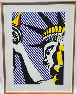
Sold2024Roy Lichtenstein I Love Liberty Silkscreen AP Signed Ed74 1982Provenance: San Francisco, California area collector retired to the Florida Gulf Coast, name withheld. One of 15 lots from the collection of Pop Art, Abstract Expressionism etc. in this sale includingSee Sold Price
6 days LeftTrillium Antique Prints & Rare BooksDe Bry - Frontispiece: Caribbean and Central AmericaUS$75
3 days LeftJasper52SOUTHERN MEXICO & CENTRAL AMERICA. Yucatan Belize Mosquito Coast. SDUK 1846 mapUS$25
4 days LeftWeatherham Estate Treasures8" x 8" Female Monarch Butterfly - Danaus Plexippus (Ventral Side)US$74
3 days LeftJasper52CENTRAL AMERICA.Panama Guatemala Nicaragua Costa Rica British Honduras 1952 mapUS$15
3 days LeftJasper52SOUTH AMERICA. Bolivia with littoral/sea coast. Patagonia. BARTHOLOMEW 1876 mapUS$8
3 days LeftJasper52BOLIVIA & PERU with a part of Brazil. Bolivia Litoral / sea coast. SDUK 1857 mapUS$10
3 days LeftJasper52BOLIVIA & PERU with a part of Brazil. Bolivia Litoral / sea coast. SDUK 1851 mapUS$15
Jun 14DuMouchellesJoseph Wilson Lowry (Bristish, 1803-1879) Hand Colored Engraving on Paper Ca. 19th Century, "WestUS$10
3 days LeftJasper52PERU & BOLIVIA. Bolivia with Atacama litoral.Potosi view TALLIS/RAPKIN 1851 mapUS$100
3 days LeftJasper52PERU & BOLIVIA. Bolivia with Atacama litoral.Potosi view RAPKIN/TALLIS 1851 mapUS$100
3 days LeftJasper52Extremité Meridionale de l'Amérique Tierra del Fuego Magellan Str BONNE 1788 mapUS$35


![Central America Caribbean Gulf of Mexico chart Ports lighthouses LARGE 1927 map: TITLE/CONTENT OF MAP: Central American and West Indian Ports [inset The Lesser Antilles; The Windward Passage; Bermudas; Kingston; Havana; Salina Cruz; Puerto Mexico; Mouths of the Mississippi] DATE P](https://p1.liveauctioneers.com/5584/316569/169897699_1_x.jpg?height=310&quality=70&version=1706046386)