Sold2021Himalaya Region Map Pair16th century AD. A group comprising two printed copper-engraved maps of the Himalayas region; based on work by Claudius Ptolemaeus; the uncoloured version with Latin text to verso, copied from GeograpSee Sold Price
Sold2022Buffon & Tardieu 1853 Pair of Maps. Polar Regions"Carte de la Region Polaire Antarctique" and "Carte de la Region Polaire Arctique" Steel Engraved Map with outline hand color Published 1853-55, Paris for "Oeuvres Completes de Buffon" by the Comte deSee Sold Price
Sold2022[GREAT LAKES REGION]. A pair of engraved maps, including: T...[GREAT LAKES REGION]. A pair of engraved maps, including: TANNER, Henry Schenk. North America: Sheet V The Northwest and Michigan Territories. London Baldwin & Cradock, 1833. Hand–outlined in coSee Sold Price
Sold2022ANTIQUE FRENCH NORMANDY MAPS ENGRAVINGS 17TH CEN.A pair of antique French hand-colored engravings maps. The first is titled, Le Pais De Cavx Normandy Part of Picardy. The Pais or Pays de Caux is a natural region of Normandy belonging to the Paris BaSee Sold Price
Sold2018Antique John Smith Atlantic Region Map Virginia OrigState 10: Page 41, numbers changed to 1690 and 1691. A true piece of American history, not a reproduction!Fine example of John Smith's map of the newly formed Virginia colony, one of the true milestonSee Sold Price
Sold2017Cary: US Western Territory/Great Lakes Region Map, 1805Map: A New Map of Part of the United States of North America, exhibiting the Western Territory, Kentucky, Pennsylvania, Maryland, Virginia &c., also the lakes Superior, Michigan, Huron, Ontario & ErieSee Sold Price
Sold2022Mexico, shows a independent Republic of Texas. Important S.W region map. 1846 by A and C BlackMexico with a independent Republic of Texas, shown at its largest territorial expanse. Although Texas would join the Union in 1845, this map was published in 1846 but was not updated in time making itSee Sold Price
Sold2017[Maps] Pair of Maps of N & S AmericaPair of Maps: AN ACCURATE MAP OF NORTH AMERICA…BY EMANUEL BOWEN. 1747. Measuring from neatline to neatline 201 x 149mm. Vertical creases as folded, clean, Very Good. ***** AN ACCURATE MAP OF SOUSee Sold Price
Sold2022Kleines Zier-Pulverhorn mit Steckdeckel an Kette - Himalaya-Region (Nordindien), wohl 19.Jh., KorpusKleines Zier-Pulverhorn mit Steckdeckel an Kette - Himalaya-Region (Nordindien), wohl 19.Jh., Korpus aus Ziegenhorn mit ornamentierten Silberbeschlägen und Steinbesatz, Länge ca. 16,5 cmSee Sold Price
Sold20172 Books Russia, Persia, Sweden, Baltic Region MapTwo books: Russia, Persia, Sweden and a Baltic Region Map. 1 - Gulzar; or, the Rose-Bower: A Tale of Persia, 212pp, John S. Reid, Published by Samuel Turner, Charles B. Davis, and G.A. & J.P. Chapman,See Sold Price
Sold20171865 GOLD REGION MAP OF CANADABy Burlend, Lafricain and Co. Montreal with smaller side map. Condition folded & loss to right side over all discolouration. 60 x 83 cm ( 23.5 x 32.5 in )See Sold Price
Sold2021Uncommon version of Colton Northern Regions mapRarely seen variant state of Colton’s map of the North Pole. Covers from Lake Baikal, the Hudson Bay, the British Isles and Kamchatka north to the Pole. Excellent overview of the state of ArcticSee Sold Price
Sold2021Uncommon version of Colton Southern Regions mapRarely seen variant state of Colton's map of the South Pole, Antarctica, or the Southern Polar Regions. Shows the great southern continent with both solid and tentatively sketched in borders. Notes thSee Sold Price
Sold2019Colton's 1855 Southern Regions Map of AntarcticaFrom Colton's 1856 Atlas of the World, published at Colton's 172 William St. office in New York. Nibbled edges and slight fading. Measures approximately 17-1/2" in height by 14-1/2" in width.See Sold Price
Sold2021PR., 18TH C. ITALIAN FAUX MARBLE PAINTED CABINETSItalian, 18th century. Piedmont region, pair of wooden single-door cabinets, having faux polychrome marble paint decoration with silver-gilt accents, paneled doors, interior fitted with shelves, and rSee Sold Price
Sold2021Tommi Parzinger Table LampTable map's, pair. Lightolier, 1950. Silver plated brass and aluminum. 8.5w x 6.25d x 19h.See Sold Price
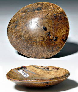
Sold2016Early Tibetan Decorated Skull CapHimalaya Region, Tibet, ca. 18th century CE. This human skull cap, known as a Kapala or Thod-pa, was made to be used in Hindu and Buddhist tantra rituals (Vajrayana). Not only are they used in ritualsSee Sold Price
Sold2021"The Hudson Valley by Daylight", Railroad, Map BooksLot of 3 Books Hudson Valley Region Map, Illustrations. The books include: "Health and Pleasure: on 'America's Greatest Railroad'" published by New York Central & Hudson River Railroad Company, 1893 aSee Sold Price
Sold2021Map of Texan, Indian Terr. & N. Mex., 1868Terrific post-Civil War school atlas map of the region. Map drawn by Oliver J. Stuart. Numerous Indian tribes, counties, towns, forts, rivers, and other details. Inset of Galveston area. Full originalSee Sold Price
Sold2016NATIVE AMERICAN BEADWORK MOCCASINSNATIVE AMERICAN BEADWORK MOCCASINS, two pairs, comprising a Great Lakes region pair with polychrome decoration against a vivid orange ground and a Tlingit seal skin pair with polychrome owl decorationSee Sold Price
Sold2022ANTIQUE CENTRAL AMERICA MAPS AND ENGRAVINGA collection of antique Central America region maps and engravings including a 1778 large detailed map of the Island of Dominica, a 1794 map of the island of Saint Vincent showing its late eighteenthSee Sold Price
Sold2022Laminated Unique Media New York City MapLaminated Unique Media "New York City And Region" Map. The map is approx 27" x 18 1/4" and it weighs 0.29lb. The map is in a good, used condition with light creases and scratches. Please see the imageSee Sold Price
Sold2022Polar.- Fullarton (Archibald) & Co. Arctic Regions,Polar.- Fullarton & Co. (Archibald) Arctic Regions, map of the Arctic showing the Northwest Passage discovered by the Irish Captain Robert McClure in 1850-53, with inset map above of the Wellington ChSee Sold Price
Sold2018India and Region Tiara PairA pair of undated archaistic gilt tiaras, each with row of glass and other bead dangles to the brow, body of cannetille with applied glass 'gems' and other detailing. 245 grams total, 12.5-15cm (5 - 6See Sold Price
Featured2 days LeftJasper52c1700 North and South Pole in vertical orientation. By P. Van der AaUS$750
3 days Left1st Source ConsignmentMoroccan Boho Chic Off - White Handmade Wedding Pillow, a PairUS$100
Jun 12Dan Morphy AuctionsPHELPS’S TRAVELERS GUIDE THROUGH THE UNITED STATES; CONTAINING UPWARDS OF SEVEN HUNDREDUS$1,000
2 days LeftJasper521719 Chatelain Map of the Adriatic and Venice Republic -- Carte de Geographie des Differents EtatsUS$190
2 days LeftJasper521640 Gerritsz/De Laet Map of Brazil -- Provincia de Brasil cum Adiacentibus ProvinciisUS$320
Jun 07Freeman's | HindmanHOMANN, Johann Baptist. Amplissimae Regionis Mississipi Seu Provinciae Ludovicianae. Nuremburg, [caUS$400(1 bid)
Jun 07Freeman's | Hindman[MAP]. ORTELIUS, Abraham. Peregrinationis Divi Pauli Typus Corographicus. 1592.US$150(1 bid)
2 days LeftJasper521890 IN DARKEST AFRICA by HENRY M. STANLEY antique 2 VOLUMES illustrated w/ mapsUS$85(2 bids)
2 days LeftJasper521720 Homann Map of the Caspian Sea Region -- Provinciarum Persicarum Kilaniae nempe ChirvaniaeUS$220
5 days LeftHargesheimer Kunstauktionen DuesseldorfANATOLY SOKOLOV PAAR GEMAELDE (BIRKENWALD (1987) / HERBSTSTI€200
2 days LeftJasper521587 Ortelius Map of Holland -- Hollandiae Antiquorum Catthorum sedis Nova Descriptio, AuctoreUS$440
Jun 07Freeman's | HindmanMURCHISON, Roderick Impey, Sir. The Silurian System. 1839. COMPLETE WITH VERY RARE HAND-COLOREDUS$1,500
6 days LeftNorthgate Gallery, Inc.Vintage Baker Furniture George II Style Wing Back Arm Chairs, PairUS$200
Jun 15Crescent City Auction GalleryPair of New Orleans Sanborn Fire Insurance Mock-Up Skeleton Maps of the French Quarter, 1910-1911,US$250


![[GREAT LAKES REGION]. A pair of engraved maps, including: T...: [GREAT LAKES REGION]. A pair of engraved maps, including: TANNER, Henry Schenk. North America: Sheet V The Northwest and Michigan Territories. London Baldwin & Cradock, 1833. Hand–outlined in co](https://p1.liveauctioneers.com/928/252933/131521733_1_x.jpg?height=310&quality=70&version=1656110480)


![[Maps] Pair of Maps of N & S America: Pair of Maps: AN ACCURATE MAP OF NORTH AMERICA…BY EMANUEL BOWEN. 1747. Measuring from neatline to neatline 201 x 149mm. Vertical creases as folded, clean, Very Good. ***** AN ACCURATE MAP OF SOU](https://p1.liveauctioneers.com/3532/107013/54846861_1_x.jpg?height=310&quality=70&version=1501119763)


![[MAP]. ORTELIUS, Abraham. Peregrinationis Divi Pauli Typus Corographicus. 1592. (1 of 2)](https://p1.liveauctioneers.com/197/329395/177650535_1_x.jpg?height=282&quality=70&version=1715364962)


