Sold2023Asher and Adams. - Maps of New York, Group of 2Lot 45 Asher and Adams. American Manufacturer (1860 - c. 1900) Maps of New York, Group of 2 lithograph with hand coloring Asher and Adams. 1872 New Topographical Atlas and Gazetteer of New York accompSee Sold Price
Sold20191872 Asher and Adams Map of Arkansas and Western IndianTitle: 1872 Asher and Adams Map of Arkansas and Western Indian Territory -- Asher & Adams's Arkansas and Portion of Indian Territory Date: 1872 New York Cartographer: Asher & Adams Size: 15.8 x 22.8 iSee Sold Price
Sold20191872 Asher and Adams Map of Kansas -- Asher & Adams'Title: 1872 Asher and Adams Map of Kansas -- Asher & Adams' Kansas Date: 1872 New York Cartographer: Asher & Adams Size: 15.8 x 22.8 in. Additional Information: A very nice, large map of Kansas with mSee Sold Price
Sold20191872 Asher and Adams Geological Map of United States --Title: 1872 Asher and Adams Geological Map of United States -- Asher & Adams' Geological Map United States and Territories Date: 1872 New York Cartographer: Asher & Adams Size: 15.8 x 22.8 in. AdditioSee Sold Price
Sold20191872 Asher and Adams Map of Europe -- Asher & Adams'Title: 1872 Asher and Adams Map of Europe -- Asher & Adams' Europe Date: 1872 New York Cartographer: Asher & Adams Size: 15.8 x 22.8 in. Additional Information: A very nice, large map of Europe. The mSee Sold Price
Sold20191872 Asher and Adams Map of Kentucky & Tennessee --Title: 1872 Asher and Adams Map of Kentucky & Tennessee -- Asher & Adams' Kentucky & Tennessee Cartographer: Asher & Adams Date: 1872 New York Size: 15.8 x 22.8 in. Additional Information: A very niceSee Sold Price
Sold2022ANTIQUE NEW YORK TOPOGRAPHICAL ATLAS MAPS DOCSAn antique edition of New topographical atlas of Jefferson Co., New York published in 1864. Also includes more antique maps and documents. Dimensions: N/ASee Sold Price
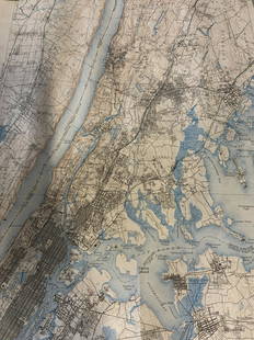
Sold2023Group lot of NEW YORK State Topographical MapsGroup lot of NEW YORK State Topographical Maps, maps measure 17 x 21 inches, wear consistent with age and use. not framed. Art, wall art, artwork, home decor, maps, topographic, topography, New York SSee Sold Price
Sold2022Group lot of NEW YORK State Topographical MapsGroup lot of NEW YORK State Topographical Maps, maps measure 17 x 21 inches, wear consistent with age and use. not framed. Art, wall art, artwork, home decor, maps, topographic, topography, New York SSee Sold Price
SoldASHER AND ADAMS Asher & Adams' New Historical and Topographical Atlas of the United States. With...ASHER AND ADAMS Asher & Adams' New Historical a...See Sold Price
Sold2019Asher and Adams New Statistical and Topographical AtlasAsher and Adams New Statistical Atlas 1872: Oversize atlas from 1872 by Asher and Adams. Atlas of the US. Light toning and fozing throughout. Early rare atlas in really good condition.See Sold Price
Sold2016Map, Hudson River, Rev. War, Sauthier, 1776At the top of the map is written: "A Topographical Map of Hudsons River, with the Channels Depth of Water, Rocks, Shoals, &c. and the Country Adjacent, from Sandy-Hook, New York and Bay to Fort EdwardSee Sold Price
Sold2021Antique Map of North Eastern United StatesMap of North Eastern of the United States, Asher and Adams, signature to lower right reads Asher & Adams’ New Hampshire, Vermont, Massachusetts, Rhode Island and Connecticut, subject a map of EasterSee Sold Price
Sold20211872 Asher and Adams Map of New England States -- AsherTitle: 1872 Asher and Adams Map of New England States -- Asher & Adams' New Hampshire, Vermont, Massachusetts, Rhode Island and Connecticut Cartographer: Asher & Adams Year / Place: 1872 New York MapSee Sold Price
Sold2024A scarce and very large plan of Montreal[MAP-CANADA] ADAMS, JOHN, surveyor. Map of the City and Suburbs of Montreal ... Constructed from a New Survey, 1825 by John Adams. New York: Engraved by J. D. Stout, 1825. Engraved map on three largeSee Sold Price
Sold20231892 Adams and Bowles New Road Map of the State of New YorkThis is a large, wall-hanging 1892 Adams and Bowles New Road Map of the State of New York. It also highlights railroad lines in the state. Paper on linen, with both top and bottom dowels present. FineSee Sold Price
Sold20191872 Asher and Adams Map of Pennsylvania and New JerseyTitle/Content of Map: 1872 Asher and Adams Map of Pennsylvania and New Jersey -- Asher & Adams' Pennsylvania and New Jersey Date: 1872 New York Cartographer: Asher & Adams Size: 15.8 x 22.8 in. A verySee Sold Price
Sold20241892 Adams and Bowles New Road Map of the State of New YorkThis is a large, wall-hanging 1892 Adams and Bowles New Road Map of the State of New York. It also highlights railroad lines in the state. Paper on linen, with both top and bottom dowels present. FineSee Sold Price
Sold2016Johnson's Delaware & Maryland, 1861Map: Johnson's Delaware and Maryland Cartographer: Johnson & Browning Publishing: New York, 1861 Size: 12.3 x 16.3 inches A highly detailed map with topographical, city / town, and rail road details.See Sold Price
Sold2017Asher & Adams: Map of Pennsylvania & New Jersey, 1872Nicely colored Asher & Adams Pennsylvania and New Jersey. 1872. 15.75 x 22.75. Striking example of an Asher & Adams map which are often pale in hand coloring, or somewhat brittle. This one is nicely cSee Sold Price
Sold20241872 Asher and Adams Map of Maine and Parts of Quebec, Vermont and New Hampshire -- Asher & AdamsTitle: 1872 Asher and Adams Map of Maine and Parts of Quebec, Vermont and New Hampshire -- Asher & Adams Maine and Part of Quebec Cartographer: Asher & Adams Year / Place: 1872 New York Map DimensionSee Sold Price
Sold20181872 Asher and Adams Map of Eastern Texas -- Asher &Reserve Reduced! Title/Content of Map: 1872 Asher and Adams Map of Eastern Texas -- Asher & Adams' Texas Date: 1872 New York Cartographer: Asher & Adams Size: 22.2 X 15.8 in. A very nice, large map ofSee Sold Price
Sold20181872 Asher and Adams Map of Florida -- Asher & Adams'Title/Content of Map: 1872 Asher and Adams Map of Florida -- Asher & Adams' Florida Date: 1872 New York Cartographer: Asher & Adams Size: 15.8 x 22.8 in. A very nice, large map of Florida. The major cSee Sold Price
23 hrs LeftJasper52A Topographical Map of the northn. part of New York Island… FADEN/STEDMAN 1794US$3,200
23 hrs LeftJasper52NEW YORK CITY antique town city map plan. Manhattan Brooklyn Jersey. SDUK 1844US$600
23 hrs LeftJasper52An accurate Map of New York, in North America… Universal Magazine 1780 oldUS$550
Oct 12JM Hobby Supply and Railroad Artifact Auctions1882 Indiana Bloomington and Western Railway MapUS$30
23 hrs LeftJasper52Johnson's New York & Adjacent Cities. Brooklyn Manhattan Jersey City 1866 mapUS$300
2 days LeftSwann Auction GalleriesVARIOUS CARTOGRAPHERS Group of 10 lithographed folding maps and plans taken from various editions ofUS$375
2 days LeftSwann Auction GalleriesHENRY F. WALLING (1825-1889) Map of the City of New York and Its Vicinity. 1866.US$1,900
3 days LeftDOYLE Auctioneers & AppraisersWilliam Adams American Coin Silver Covered Meat Platter New York, circa 1840US$500(1 bid)
4 days LeftPUBLIC SALE1929 Insurance Maps of Brooklyn NY Atlas, Sanborn Hardcover FolioUS$100(2 bids)
Oct 12JM Hobby Supply and Railroad Artifact AuctionsNew York State Railways Adams and Westlake Tail LampUS$100
2 days LeftSwann Auction GalleriesEGBERT L. VIELE; and G.W. & C.B. COLTON Map of the City of New York Showing the Proposed Route ofUS$600


![A scarce and very large plan of Montreal: [MAP-CANADA] ADAMS, JOHN, surveyor. Map of the City and Suburbs of Montreal ... Constructed from a New Survey, 1825 by John Adams. New York: Engraved by J. D. Stout, 1825. Engraved map on three large](https://p1.liveauctioneers.com/292/326828/175962870_1_x.jpg?height=310&quality=70&version=1713473479)


