Sold20221855 Colton Map of Western Africa -- Africa North Western SheetTitle: 1855 Colton Map of Western Africa -- Africa North Western Sheet Cartographer: J Colton Year / Place: 1855, New York Map Dimension (in.): 14.9 X 13 in. This is a very nice map of north and westSee Sold Price
Sold2017J. H. Colton: Africa (Northwestern Sheet) MapAfrica (Northwestern sheet), 14 x 17 in, 1857, J. H. Colton Please note that this lot has a confidential reserve. When you leave a bid in advance of the auction, submit your maximum. Jasper52 will bidSee Sold Price
Sold2016Map of Africa (northwest) by Colton, 1875Original engraving of the northwestern portion sheet by Colton, 1875. Dimensions: 13 3/4" x 17 1/4" No Reserve Buyer pays shipping - ships from Ocean View, DESee Sold Price
Sold20221855 Colton Map of Northeastern Africa -- Africa North Eastern SheetTitle: 1855 Colton Map of Northeastern Africa -- Africa North Eastern Sheet Cartographer: J Colton Year / Place: 1855, New York Map Dimension (in.): 14.6 X 12 in. This is a very nice map of northeastSee Sold Price
Sold2016Bowen map of North Africa 1747Heading: (Map) Author: Bowen, Emanuel Title: A New & Accurate Map of the Western Parts of Barbary [on sheet with] A New & Accurate Map of the Eastern Parts of Barbary Place Published: London PublisherSee Sold Price
Sold20221855 Colton Map of Southern Africa -- Africa Southern SheetTitle: 1855 Colton Map of Southern Africa -- Africa Southern Sheet Cartographer: J Colton Year / Place: 1855, New York Map Dimension (in.): 11.8 X 15.3 in. This is a very nice map of southern Africa iSee Sold Price
Sold2017Bellin Map of West North Africa & Canary Islands, 17501750 Bellin Map of Western North Africa and Canary Islands -- Coste Occidentale D'Afrique. This is Bellin's map of the northwestern coast of Africa. It covers from the Strait of Gibraltar to just beloSee Sold Price
Sold2024North East Africa. Egypt Abyssinia Arabia Abu Dhabi Sharja. COLTON 1869 mapTITLE OF MAP (NOT PRINTED ON THE PAGE):'Africa - north eastern sheet' DATE PRINTED: 1869 IMAGE SIZE: Approx 42.0 x 33.5cm, 16.5 x 13.25 inches (Large) TYPE: Antique engraved hand coloured atlas map COSee Sold Price
Sold2020SDUK: West Africa (Senegal to Cameroon) in 2 sheetsA pair of highly detailed maps of western Africa from the Society for the Diffusion of Useful Knowledge atlas. Plate I extends from the Senegal River to the Volta River, in what is now Ghana, and inlaSee Sold Price
Sold2023MAP, Africa, MercatorNorthwestern Africa. Mercator/Hondius, Fessae Regnum, from Atlas Minor, 1609 (published). Hand Color. This charming small map of Morocco and Algeria extends south to Beninia and Nussini and includes tSee Sold Price
Sold2024Historical Nautical Chart of Atlantic Ocean Map c.1650This attractive map of the Atlantic Ocean (Mar del Nort) is extended to include much of North America, Europe, and western Africa; though interior details are relatively scarce, especially in the WestSee Sold Price
Sold2019Two Maps: consisting of J. H. Colton, "North America,"Two Maps: consisting of J. H. Colton, "North America," 1860, hand colored, H.- 13 3/4 in., W.- 11 1/4 in.; together with Johnson & Browning, "Africa," 1855, hand colored, H.- 17 1/2 in., W.- 16 in. (2See Sold Price
Sold20191855 Colton Map of the Western Hemisphere -- WesternTitle/Content of Map: 1855 Colton Map of the Western Hemisphere -- Western Hemisphere Date: 1855, New York Cartographer: J Colton Size: 14.5 X 13.7 in. This is an excellent hemispherical map. The coasSee Sold Price
Sold20211852 Tallis Map of Western Africa -- Western AfricaTitle: 1852 Tallis Map of Western Africa -- Western Africa Cartographer: J. Tallis Year / Place: 1852 London Map Dimension (in.): 9.8 X 13 in. This is an ornate and highly decorative map of West AfricSee Sold Price
Sold2021Tallis, John (Pub) 1852 Map. Western AfricaSteel Engraved Map with Original Outline Hand Color Published 1852-56 by John Tallis, London for "The Universal Pronouncing Dictionary" by Thomas Wright. Drawn & Engraved by John Rapkin. Centre fold aSee Sold Price
Sold2019Africa.- De L'Isle (Guillaume) Carte de la Barbarie deAfrica.- De L'Isle (Guillaume) Carte de la Barbarie de la Nigritie et de la Guinée, map of western Africa from Barbary, Nigeria, and Guinea to below the equator, with numerous tent encampments deSee Sold Price
Sold20201806 Durant Coastal Map of Western Africa During SlaveTitle/Content of Map: 1806 Durant Coastal Map of Western Africa During Slave Trade Period -- Map of the Western Coast of Africa from Cape Blanco to the River Sierra leonewith the Courses of the RiverSee Sold Price
Sold20181760 Bellin Map of Western Africa Coast from Nigeria toReserve Reduced! Title/Content of Map: 1760 Bellin Map of Western Africa Coast from Nigeria to Gabon -- Carte du Golfe de Guinee Et les Costes comprises entre le Cap Formosa et le Cap de Lopes ConsalvSee Sold Price
Sold20211882 West Africa MapAuthor: Blackie Title: 1882 West Africa Map Medium: Ink on Paper Dimenions: 21"X15" Description: Map of Western Africa dated 1882. Part of the Comprehensive Atlas & Geography of the World. Engraved bySee Sold Price
Sold2018Antiuqe Map of Coastal Western Africa by BellinTitle/Content of Map: Coastal Western Africa by Bellin Date Printed: 1740-70's Cartographer: J.N. Bellin & J.F. La Harpe Material/Medium: Paper Size: 14" x 9" Provenance: New York From the 'Abrege deSee Sold Price
Sold2018North western Africa by Bellin 1740-70s.North western Africa by Bellin 1740-70s. Approx. 12 x 9” Please note that this lot has a confidential reserve. When you leave a bid in advance of the auction, submit your maximum. The bidder who hasSee Sold Price
Sold2021North African Paleolithic Acheulean Stone Hand AxeNorthwestern Africa, Algeria / Morocco, Acheulean (Lower Paleolithic), ca. 1.2 million to 500,000 years ago. This is a large and remarkable hand-knapped stone tool that functioned as a hand axe. The bSee Sold Price
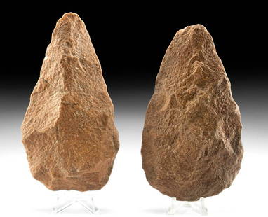
Sold20222 Paleolithic Acheulean North African Stone Hand AxesNorthwestern Africa, Algeria, Sahara Desert, Ternifine, Acheulean, Lower Paleolithic, Acheulean period, ca. 1.7 million to 500,000 years ago. A pair of hand-knapped bifacial tools used as hand axes maSee Sold Price
Sold2021Sahara Homo Ergaster Acheulean Stone Lanceolate AxeNorthwestern Africa, Sahara Desert, Acheulean (Lower Paleolithic), ca. 1.2 million to 500,000 years ago. This stone tool is a lanceolate hand axe with incredible flaking, design, and size! The AcheuleSee Sold Price
4 days LeftJasper521593 de Jode Maps of Eastern Germany (Saxony Area) and Western Germany -- Mansfeldiae Comitatus ...US$700
4 days LeftJasper521723 Dampier Map of Voyages to Brazil, Australia and Eat Indies -- Voyage du Cap. Dampier a la N.US$280
5 days LeftJasper52PERU BOLIVIA CHILE.shows battles/dates inc.War of the Pacific 1877-80 1903 mapUS$25
5 days LeftJasper52Amér Mér. Colombie #5 Eastern Colombia. NW Amazonas Brazil VANDERMAELEN 1827 mapUS$100
5 days LeftJasper52Amér. Mér. Colombie #2. Western Venezuela & NE Colombia. VANDERMAELEN 1827 mapUS$100
Jun 08Leon GalleryGiovanni Battista Ramusio (1485 - 1557) Giacomo Gastaldi (1500 - 1566) - Terza Ostro Tavola (The₱1,300,000
5 days LeftForum Auctionsd'Anville (Jean Baptiste Bourguignon) [Untitled Composite Atlas with 102 map sheets], [probably£2,000
5 days LeftJasper52Amér Mér Colombie & Brésil 9 Peru Colombia Amazonas Brazil VANDERMAELEN 1827 mapUS$70
5 days LeftJasper52Extremité Meridionale de l'Amérique Tierra del Fuego Magellan Str BONNE 1788 mapUS$35
5 days LeftJasper52AMAZONIA. Showing Indian tribes. Guyana Surinam Brazil. Recife. SDUK 1844 mapUS$10
5 days LeftJasper52AMAZONIA. Showing Indian tribes. Guyana Surinam Brazil. Recife. SDUK 1844 mapUS$10
5 days LeftJasper52AMAZONIA. Showing Indian tribes. Guyana Surinam Brazil. Recife. SDUK 1851 mapUS$15
5 days LeftJasper52AMAZONIA showing "El Dorado?" & Missions. Brazil Ecuador Colombia SDUK 1874 mapUS$120
5 days LeftJasper52AMAZONIA.Showing "El Dorado?", missions & tribes. Brazil Ecuador.SDUK 1844 mapUS$130


![Bowen map of North Africa 1747: Heading: (Map) Author: Bowen, Emanuel Title: A New & Accurate Map of the Western Parts of Barbary [on sheet with] A New & Accurate Map of the Eastern Parts of Barbary Place Published: London Publisher](https://p1.liveauctioneers.com/642/86438/44449747_1_x.jpg?height=310&quality=70&version=1458591928)


![d'Anville (Jean Baptiste Bourguignon) [Untitled Composite Atlas with 102 map sheets], [probably (1 of 3)](https://p1.liveauctioneers.com/5458/329231/177514974_1_x.jpg?height=282&quality=70&version=1715269091)


