Sold2023FRAMED 19TH C. JOHNSON'S FLORIDA MAP1863 Civil War Era Colored Map of Florida, by Alvin Jewett Johnson (1827-1884), published by Johnson & Ward, New York, in a gilded and green painted wooden frame with mat, glazed, OS: 19 1/2" x 23 1/2See Sold Price
Sold2024Scarce Georgia-Alabama Civil War-era RR map by Johnson & Browning, 1861Johnson’s Georgia and Alabama from the scarce 1861 edition of Johnson’s Family Atlas published shortly after the outbreak of the war in 1861 by Johnson & Browning. Shows network of railroaSee Sold Price
Sold20241862 Civil War-era map of Alabama/Georgia, Johnson & WardJohnson’s Georgia and Alabama from the 1862 edition of Johnson’s Family Atlas published during the second year of the war in 1862 by Johnson & Ward. Shows railroads operating at the beginnSee Sold Price
Sold202419th C. Johnson’s Florida Map1863 Civil War era colored map of Florida by Alvin Jewett Johnson, published by A.J Johnson New York. Unframed in protective sleeve. Measures just shy of 14 inches by 18 inches.See Sold Price
Sold2019United States. Civil war era military map. ShowingTitle/Content of Map: United States. Civil war era military map. Showing southern ports Date: 1863 Cartographer: By Johnson & Ward. From, Johnson’s New Illustrated Family Atlas Size: 18x 26 1/4”.See Sold Price
Sold2022Significant United States map, 1864 Johnson & WardVery interesting hand-colored map created at a pivotal time in the settlement of the American West. In this lovely Civil War era map many of the western states have still not settled their borders. ArSee Sold Price
Sold2023Nice 1865 map of Florida from Johnson and WardJohnson’s Florida dated 1863 and published in the last year of the Civil War with entire lower part of the state undeveloped. Johnsons New Illustrated Family Atlas began its publishing history iSee Sold Price
Sold2023Nice 1865 map of Florida from Johnson and WardJohnson’s Florida published in the last year of the Civil War and showing entire lower part of the state as undeveloped. Johnsons New Illustrated Family Atlas began its publishing history in 1860 anSee Sold Price
Sold2017Johnson’s 1862 map of Florida with wide marginsScarce map offers a wonderful snapshot of this secessionist state shortly following the outbreak of the American Civil War. Sharp example of the first Johnson & Ward map of Florida. The Johnson FamilySee Sold Price
Sold2023Great Civil War era RR map of Kentucky & TennesseeA map produced toward the end of the Civil War, it oddly features two states who wound up fighting against each other. Tennessee, for its part, had more fighting than any other state other than VirginSee Sold Price
Sold2022Scarce Civil War era map of Florida with great detail,Great map of Florida showing the entire state (includes small inset of Florida Keys). Shows state shortly after the outbreak of the Civil War. Notes proposed course of a canal route from Tampa to theSee Sold Price
Sold2023Civil War era map of Florida, 1863Lovely early map of Florida, vividly hand colored by county, with a large inset of the Florida Keys. Shows towns, railroads, villages, post offices, forts, etc. Only five counties shown in the southerSee Sold Price
Sold2017Johnson’s Civil War era map of North & South CarolinaHistoric map shows the Carolinas in great detail shortly following the outbreak of the Civil War. States hand-colored at the time of publishing with color coding according to county. Inset map depictsSee Sold Price
Sold2021CIVIL WAR-ERA JOHNSON'S MILITARY MAP UNITED STATESFramed engraving with color on paper, "Johnson's New Military Map of the United States, Showing the Forts, Military Posts & c., with Enlarged Plans of Southern Harbors from Authentic Data Obtained atSee Sold Price
Sold2022Great 1863 Civil War Military Map of U. S. by Johnson & WardWhile America was involved with the Civil War, atlas publishers like Johnson and Ward produced detailed maps to capitalize on the nation’s interest in that conflict. This is the more desirable of thSee Sold Price
Sold2024Civil War era map of N. America with unsettled state bordersOne of the key maps in the 1860s Johnson series of North America. In this map Idaho Territory encompasses what would eventually become Idaho, Montana and Wyoming. Dakota Territory has yet to split intSee Sold Price
Sold2023Civil War era map of N. America with unsettled state bordersOne of the key maps in the 1860s Johnson series of North America. In this map Dakota Territory has yet to split into its north and south divisions while it stretches to encompass what will eventuallySee Sold Price
Sold2022Civil War era map of N. America with unsettled state bordersOne of the key maps in the 1860s Johnson series of North America. In this map Idaho Territory encompasses what would eventually become Idaho, Montana and Wyoming. Dakota Territory has yet to split intSee Sold Price
Sold2020Early Civil War era map of AmericaNice example of A. J. Johnson's 1862 map of North America. Presents a fascinating snapshot of North America just after the outbreak of the American Civil War. States generally follow the 1861 configurSee Sold Price
Sold202319th century. A hand-colored American Civil War era map of Virginia, Delaware, Maryland, and West19th century. A hand-colored American Civil War era map of Virginia, Delaware, Maryland, and West Virginia. Published by A.J. Johnson New York USA. Marked as page 47. Overall good condition; some browSee Sold Price
Sold2020Johnson's IllinoisTitle/Content of Map: Johnson's Illinois Cartographer: JOHNSON, ALVIN JEWETT Date: 1866 Publisher: A.J. Johnson Size: 22Height - 15.6Width Larger Civil War era Illinois. Slightly browned. EncapsulatedSee Sold Price
Sold2018Two Civil War Era Mitchell MapsMap of North America Showing Its Political Divisions and county maps of North Carolina, South Carolina, and Florida on one sheet (Philadelphia: S. Augustus Mitchell, 1860). Not framed. 15.25 x 12.25 iSee Sold Price
Sold20181864 Johnson Map of the United States -- Johnson'sTitle/Content of Map: 1864 Johnson Map of the United States -- Johnson's United States Date: 1864, New York Cartographer: A Johnson Size: 16.9 x 23.1 in. This is a large, highly detailed Civil War eraSee Sold Price
Sold2022Civil War Military map - scarce territorial bordersThe Johnson and Ward atlas company produced two memorable, double-page Civil War maps of the United States. This is the more desirable issue, showing the state and territory borders instead of the MilSee Sold Price
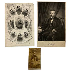
16 hrs LeftLakeshore Event CenterEphemera, Civil War Generals, Abraham Lincoln, Ulysses Grant, Lot of 3US$62(2 bids)
Jul 07Case Antiques, Inc. Auctions & Appraisals3 Civil War Era Photos, incl. Rose O'Neal Greenhow, poss. Jeff DavisUS$150
2 days LeftSchilb Antiquarian Rare Books1918 Robert E Lee Civil WAR Confederate General CSA Battles MAPS IllustratedUS$62(6 bids)
Featured5 days LeftUniversity ArchivesAbraham Lincoln PSA GEM MT 10 CDV, Signed 3 Weeks Before His Death.US$30,000(1 bid)
2 days LeftSchilb Antiquarian Rare Books1890 1ed Confederate Memoirs of Joseph Johnston & Jefferson Davis Civil War CSAUS$66(3 bids)
Featured5 days LeftUniversity ArchivesCapture of Jefferson Davis: “Mr. Davis tried to escape…with a ladies waterproofUS$1,600
6 days LeftSwann Auction Galleries(CIVIL WAR--CONFEDERATE.) A late issue of the Daily Constitutionalist, one of the last ConfederateUS$450
Jul 14Schilb Antiquarian Rare Books1928 Life of Abraham Lincoln 1ed SLAVERY Civil War Albert Beveridge 2v SETUS$1(1 bid)
17 hrs LeftActivity AuctionsJefferson Davis Autograph Signed Civil War Confederate President Framed (JSA LOA)US$1,400
6 days LeftSwann Auction Galleries(ABRAHAM LINCOLN.) [Alexander Gardner], photographer. Carte-de-visite "inkwell portrait" of theUS$1,500
Jul 04Weatherham Estate TreasuresAbraham Lincoln Bronze Bust Sculpture On Marble Base - Signed Original - 10lbsUS$400
7 days LeftSouth Florida Auction & Estate Sale Services IncABRAHAM LINCOLN Memorial Belt Buckle Approved by MRS. LINCOLNUS$22(2 bids)
7 days LeftSouth Florida Auction & Estate Sale Services IncCivil War Abraham Lincoln Tin Type PhotographUS$8(2 bids)
Jul 14Schilb Antiquarian Rare Books1885 Civil War 1ed Memoirs of Union General Ulysses S. Grant Illustrated MAPS 2vUS$135(7 bids)
5 days LeftUniversity ArchivesMilitary Telegrapher and Former Assistant Secretary of War Thomas T. Eckert Testifies in ImpeachmentUS$2,000
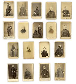
5 days LeftUniversity Archives18 pc. CDV Archive of Civil War Generals Incl. Many Brady & E. Anthony ExamplesUS$260(1 bid)
Jul 06Case Antiques, Inc. Auctions & AppraisalsCivil War Veteran GAR Uniform, PVT Stephen F. OliverUS$200(1 bid)


![(ABRAHAM LINCOLN.) [Alexander Gardner], photographer. Carte-de-visite "inkwell portrait" of the (1 of 1)](https://p1.liveauctioneers.com/199/334052/180497937_1_x.jpg?height=282&quality=70&version=1718909401)