Sold2022WEST INDIES. 1600-1660. Caribbean, Colonial Era, sketch map 1942 oldTITLE/CONTENT OF MAP: 'The Caribbean in the Colonial Era' DATE PRINTED: 1942 IMAGE SIZE: Approx 11.5 x 15.5cm, 4.5 x 6 inches (Small) TYPE: Vintage map. This map was published in 1942 but it may depicSee Sold Price
Sold2024West Indies Islands & Central America. Caribbean. STANFORD 1894 old mapDescriptionCAPTION PRINTED BELOW PICTURE: 'The West Indies'DATE PRINTED: 1894IMAGE SIZE: Approx 51.5 x 64.5cm, 20.25 x 25.5 inches (Large); Please note that this is a folding map.TYPE: Large (folio) aSee Sold Price
Sold2024West Indies Caribbean Florida Bahamas Cuba ADMIRALTY chart 1876 (1949) old mapTITLE/CONTENT OF MAP: 'West Indian Islands and Caribbean Sea - Sheet I - Comprising Florida Strait, Bahama Islands and the Greater Antilles' DATE PRINTED: Surveyed to 1948. Published 1876. New editionSee Sold Price
Sold2024The West Indies and Central America. Jamaica & Caribbean. LOWRY 1860 old mapCAPTION PRINTED BELOW PICTURE: The West Indies and Central America [Showing the Colonies in possession of the various European Powers; with enlarged map Of] Jamaica DATE PRINTED: 1860 IMAGE SIZE: ApprSee Sold Price
Sold2023West Indies. Caribbean. The American Mediterranean 1885 old antique map chartTitle: West Indies. Caribbean. The American Mediterranean 1885 old antique map chart Description: West Indies' by Engraved for Élisée Reclus (1885). Antique colour map; Scale 1:12,000,000, 3See Sold Price
Sold2024West Indies. Caribbean. The American Mediterranean 1885 old antique map chartTITLE/CONTENT OF MAP: 'West Indies' DATE PRINTED: 1885 IMAGE SIZE: Approx 33.0 x 24.5cm, 13 x 9.5 inches (Large); Please note that this is a folding map. TYPE: Antique colour map; Scale 1:12,000,000 CSee Sold Price
Sold2023West Indies and Central America. Caribbean. STANFORD c1925 old vintage mapTitle: West Indies and Central America. Caribbean. STANFORD c1925 old vintage map Description: West Indies and Central America' by Edward Stanford Ltd. (The map is undated; we estimate publication atSee Sold Price
Sold2023West Indies and Central America; Inset British Guiana. Caribbean 1898 old mapTitle: West Indies and Central America; Inset British Guiana. Caribbean 1898 old map Description: West Indies and Central America; Inset map of British Guiana' by John Bartholomew & Co., Edinburgh (18See Sold Price
Sold2024West Indies & Caribbean. Panama Canal. Relief. THE TIMES 1922 old vintage mapTITLE/CONTENT OF MAP: 'The West Indies' DATE PRINTED: 1922 IMAGE SIZE: Approx 44.5 x 57.5cm, 17.5 x 22.5 inches (Large); Please note that this is a folding map. TYPE: Antique atlas map CONDITION: GoodSee Sold Price
Sold2023PORT OF SPAIN. Vintage map. Trinidad. West Indies. Caribbean 1927 oldPart of Port of Spain, Trinidad' by Sifton, Praed & Co. Ltd, St. James's St. London S.W. (1927). Vintage map, 17.5 x 14.5cm, 6.75 x 5.5 inches; Please note that this is a folding map. TITLE/CONTENT OFSee Sold Price
Sold2024Gulf of Mexico. Caribbean West Indies. USCGS sea chart 1928 (1930) old mapTITLE/CONTENT OF MAP: 'Gulf of Mexico' DATE PRINTED: Published 1928. Reissued 1930. Corrections to 1930 IMAGE SIZE: Approx 89.0 x 107.5cm, 35 x 42.25 inches (Large); Please note that this is a foldingSee Sold Price
Sold2024CARIBBEAN. West Indies & Central America. Britannica 9th edition 1898 old mapTITLE/CONTENT OF MAP: 'West Indies' DATE PRINTED: 1898 IMAGE SIZE: Approx 18.0 x 24.5cm, 7.25 x 9.75 inches (Medium) TYPE: Antique coloured map CONDITION: Good; suitable for framing. However, please nSee Sold Price
Sold2024CENTRAL AMERICA. Mexico & Caribbean. Panama canal. BARTHOLOMEW 1898 old mapTITLE/CONTENT OF MAP: 'Mexico, Central America & West Indies; Inset map of Mexico; Panama' DATE PRINTED: 1898 IMAGE SIZE: Approx 31.5 x 43.5cm, 12.5 x 17 inches (Large); Please note that this is a folSee Sold Price
Sold2022CUBA. Vintage map. Inset Puerto Rico. West Indies. Caribbean 1923 oldTITLE/CONTENT OF MAP: 'Cuba; Inset map of Porto Rico' DATE PRINTED: 1923 IMAGE SIZE: Approx 14.5 x 24.0cm, 5.75 x 9.5 inches (Medium); Please note that this is a folding map. TYPE: Vintage colour mapSee Sold Price
Sold2022(CARIBBEAN.) Emanuel Bowen. A New and Accurate Chart of the West Indies with the Adjacent Coasts of(CARIBBEAN.) Emanuel Bowen. A New and Accurate Chart of the West Indies with the Adjacent Coasts of North and South America. Double-page engraved map of colonial North America and the western AtlanticSee Sold Price
Sold2024MILLING ROAD CARIBBEAN COLONIAL TROPICAL KING BEDMilling Road, a division of Baker Furniture, king size possibly "West Indies' collection tropical style mahogany bed, having low pineapple posts, caned head and footboard, side rails, and rising on tuSee Sold Price
Sold2023General Map of the West Indies'. West sheet only. Bryan EDWARDS. Caribbean 1794Title: General Map of the West Indies'. West sheet only. Bryan EDWARDS. Caribbean 1794 Description: A New Map of the West Indies for the History of the British Colonies by Bryan Edwards' by Bryan EdwaSee Sold Price
Sold2022Antique West Indies British Colonial Style Hand Carved Solid Wood Caned SetteeVintage from the 19th century Materials: wood, rattan Description Antique West Indies British Colonial Styled Hand Carved Solid Wood Caned Settee Stunning Antique West Indies Regency Style Hand-CarvedSee Sold Price
Sold20241719 Map of Colonial era North America, by Sanson - JaillotTitle: 1719 Map of Colonial era North America, by Sanson - Jaillot Date/Period: 1719 Materials: Copperplate engraved Size: 25 1/2 x 18” This map is a rare and valuable map of history, showing NoSee Sold Price
Sold202119th C Caribbean Mahogany Sideboard or Cupping TableA rare cupping or serving board from Barbados, circa 1830. This West Indies sideboard has mahogany primary wood with cedrela secondary wood. The serving table features a formal back splash with magnifSee Sold Price
Sold202119th C West Indies Regency Mahogany and Cane RecamierA 19th century Caribbean Regency mahogany recamier from Barbados, circa 1830, with handwoven caning, stylized acanthus and wave carvings and turned inverted tulip legs ending with original cup castersSee Sold Price
Sold2021A COLONIAL MAP, "Carte de la Louisiane et du Cours duA COLONIAL MAP, "Carte de la Louisiane et du Cours du Mississipi," PARIS, JUNE 1718, hand colored engraving on paper, "Dressée sur un grand nombre de Mémoires entr'autres sur ceux de Mr. le Maire paSee Sold Price
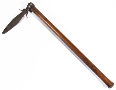
Sold2022RARE NATIVE AMERICAN / FRONTIERSMAN COLONIAL-ERA PIPE TOMAHAWKRARE NATIVE AMERICAN / FRONTIERSMAN COLONIAL-ERA PIPE TOMAHAWK, triangular blade, iron with steel blade edge, oval eye flanked by two vertical ridges to each side, octagonal bowl-form pipe poll on octSee Sold Price
Sold2022FINE COLONIAL-ERA NATIVE AMERICAN SPONTOON TOMAHAWKFINE COLONIAL-ERA NATIVE AMERICAN SPONTOON TOMAHAWK, French-style blade of thin tapered form with punched dots along the lower edges and two up-curled side flanges, likely original hickory haft with bSee Sold Price
Jun 14DuMouchellesJoseph Wilson Lowry (Bristish, 1803-1879) Hand Colored Engraving on Paper Ca. 19th Century, "WestUS$10
Jun 08Early American History Auctions1720 Colonial Northumberland County Virginia Manuscript Deed and Map PlotUS$400
2 hrs LeftSouth Florida Auction & Estate Sale Services IncOld West PRECIOUS PUSSY Whorehouse Brothel PosterUS$40(5 bids)
Jun 08Early American History Auctions1680 WILLIAM AYSCOUGH ALS as British MP, for Preservation of Religious Freedom + Property RightsUS$800
Jun 15Hess Fine AuctionsEdwardian Old Cut Multi Gemstone Diamond Antique Gold Dangle Necklace w/ ProvenanceUS$2,000(7 bids)
4 hrs LeftTRIBAL GATHERINGSOld Carved Dogon Ancestor Shrine Sculpture Ex Banks CollectionUS$50(1 bid)
Jun 08Early American History Auctions1757 Custom-House, Philadelphia, French + Indian War Era Partly-Printed DocumentUS$180
1 day LeftSanta Cruz Auction CompanyJohan le Ducq (1629 - 1676) Old Master Engraving of Dogs 1661US$150


![The West Indies and Central America. Jamaica & Caribbean. LOWRY 1860 old map: CAPTION PRINTED BELOW PICTURE: The West Indies and Central America [Showing the Colonies in possession of the various European Powers; with enlarged map Of] Jamaica DATE PRINTED: 1860 IMAGE SIZE: Appr](https://p1.liveauctioneers.com/5584/316569/169897385_1_x.jpg?height=310&quality=70&version=1706046386)