Sold2023Vintage Benefic Press Pull Down Map of AfricaColorful Benefic Press pull down map of Africa with wood and metal frame that would have been used in a school classroom. Map dates between 1960-1965 based on the country names depicted (Republic of CSee Sold Price
Sold2021Seven Vintage Pull Down Maps.A.J. Nystrom & Co United States and Mexico, 60 x 40 inches. Bacon's Standard Map of Africa, 50 x 34 inches. Bacon's Standard Map of the World in Hemispheres, 40 x 48 inches. Bacon's StSee Sold Price
Sold2023Vintage Map Print - Africa - Eastern Mediterranean - Middle East - Egypt - 1972Title/Artist: Vintage Map Print - Africa - Eastern Mediterranean - Middle East - Egypt - 1972 Date: 1972Paper Dimensions: 93 cm x 28 cm Description: A wonderful lithographic map from a magazine NationSee Sold Price
Sold2021Vintage Pull Down Map Hearne Brothers Official ChicagoVintage 1960s Retractible Pull Down Map Hearne Brothers Official Chicago and Southern Cook County . Measures approx 48" x 68" Condition: Map is partially disconnected from the bottom rod. PleSee Sold Price
Sold2018VINTAGE PULL DOWN MAP OF PENNSYLVANIAVINTAGE PULL DOWN MAP OF PENNSYLVANIA - No PS137; Published by AJ Nystrom & Co, Chicago; all county lines drawn; cities labeled; terrain mapped in high color; great teaching tool ; Condition - Map pulSee Sold Price
Sold2020(3 Pc) Framed Vintage MapsDESCRIPTION: A lot of three vintage maps depicts Asia, Africa and the Mediterranean. Provenance: Purchased from Neville Sargent Gallery CIRCA: Early - Mid 20th Cent. DIMENSIONS: H: 15" W: 18" CONDITIOSee Sold Price
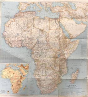
Sold2020Vintage National Geographic Map of AfricaDescription: Vintage color paper map from National Geographic Magazine depicts Africa. Some tearing on bottom. Map is copyrighted from 1943. Material: paper. Measurement: approximate 26.5"h x 34"w (INSee Sold Price
Sold2019England Classroom Map by Denoyer-GeppertA vintage England pull-down classroom map by Denoyer-Geppert. This piece is constructed of cloth with a vinyl backing and wooden frame. Condition: Wear consistent with age and history. Dimensions:See Sold Price
Sold2023Battles in South Africa Including The Zulu War, Moodie, Duncan, Campbell, Francis, Adelaide 1879, GeCloth bound book with gilt lettering on binding,5” x 7-1/2”. Moderate pulling of spline. Black and white plate illustrations throughout. Pull-out color map of South Africa. Minimal tears,See Sold Price
Sold2018Vintage Hearne Brothers Map of Stamford CTVintage Hearne Brothers Polyconic Projection Pulldown Map of Stamford metropolitan area Connecticut. Some creases in map and five small tears to left side. Slight rusting to top metal bracket. MeasureSee Sold Price
Sold2022Vintage Map Print - Map of the World - Africa - Europe - Australia - 1972Title: Vintage Map Print - Map of the World - Africa - Europe - Australia - 1972 Description: A wonderful lithographic map from a magazine National Geographic. National Geographic has been publishingSee Sold Price
Sold2024North East Africa 1885 old antique vintage map plan chartTITLE/CONTENT OF MAP: 'North East Africa' DATE PRINTED: 1885 IMAGE SIZE: Approx 31.5 x 23.0cm, 12.5 x 9 inches (Large); Please note that this is a folding map. TYPE: Antique colour map CONDITION: GoodSee Sold Price
Sold2022Vintage AJ Nystrom & Co Pull Down Schoolroom MapsFour Vintage Pull Down School Room World Mapspublished by A.J. Nystrom & Co, Chicago. Landform Physical + Political Series.See Sold Price
Sold2019North/South American Classroom Map by CRAMA vintage North/South American pull-down classroom map by CRAM. This piece is constructed of paper with a vinyl backing and wooden frame. Condition: Minor wear consistent with age and history. DimensiSee Sold Price
Sold2021VTG OSTRICH EGG W MAP OF AFRICA & THE BIG FIVEVINTAGE DECOUPAGE OSTRICH EGG WITH MAP OF AFRICA FEATURING THE BIG FIVE ANIMALS -6" X 5" DIAMETER APPROX-VERY GOOD CONDITION-DP93021See Sold Price
Sold2024Isothermal Lines of Africa. Sketch map 1885 old antique vintage plan chartTITLE/CONTENT OF MAP: 'Isothermal Lines of Africa' DATE PRINTED: 1885 IMAGE SIZE: Approx 13.5 x 12.0cm, 5.25 x 4.75 inches (Small) TYPE: Antique engraved sketch map CONDITION: Good; suitable for framiSee Sold Price
Sold2023L'Africa. DE ROSSI / SANSON 1677 old antique vintage map plan chartTITLE/CONTENT OF MAP: L'Africa [Africa] DATE PRINTED: 1677 IMAGE SIZE: Approx 42.5 x 57.0cm, 16.75 x 22.25 inches (Large) TYPE: Antique 17th century folio atlas map CONDITION: Good; suitable for framiSee Sold Price
Sold2023AFRICA. Political Map of showing International Boundaries 1936 old vintageTITLE/CONTENT OF MAP: 'Political Map of Africa showing International Boundaries' DATE PRINTED: 1936 IMAGE SIZE: Approx 24.0 x 21.5cm, 9.5 x 8.25 inches (Medium) TYPE: Colour vintage map CONDITION: GooSee Sold Price
Sold2023AFRICA. Africa. Britannica 9th edition 1898 old antique vintage map plan chartTITLE/CONTENT OF MAP: 'Africa' DATE PRINTED: 1898 IMAGE SIZE: Approx 26.0 x 32.5cm, 10.25 x 12.75 inches (Large); Please note that this is a folding map. TYPE: Antique coloured map CONDITION: Good; suSee Sold Price
Sold2017Collection of 35 vintage mapsCollection of 35 vintage maps mostly from The National Geographic Magazine including Northern Africa; The Philippines; The Top of the World; Scandinavia; Northern Europe; Southwestern United States; JSee Sold Price
Sold2022Wolters (Pub) 1932 Lot of 13 Vintage MapsIncl East Indies, Java, Borneo, Malaya, Africa, Australia, North America/Mexico, Surinam, and Pacific. Lithograph Maps Published 1932 by J. B. Wolters, Groningen, Netherlands for "Bos-Niermeyer SchoolSee Sold Price
Sold2024SECOND WORLD WAR AFRICA. European colonies & German mandates 1940 old mapTITLE/CONTENT OF MAP: 'Africa: Political, Showing European Partition' DATE PRINTED: 1940 IMAGE SIZE: Approx 27.0 x 22.5cm, 10.5 x 9 inches (Medium) TYPE: Vintage colour map; Scale 1:35,000,000 CONDITISee Sold Price
Sold2023SECOND WORLD WAR AFRICA. European colonies & German mandates 1940 old mapTITLE/CONTENT OF MAP: 'Africa: Political, Showing European Partition' DATE PRINTED: 1940 IMAGE SIZE: Approx 27.0 x 22.5cm, 10.5 x 9 inches (Medium) TYPE: Vintage colour map; Scale 1:35,000,000 CONDITISee Sold Price
Sold2024Pre-SECOND WORLD WAR AFRICA. European colonies & German mandates 1942 old mapTITLE/CONTENT OF MAP: 'Africa: European partition, pre-war' DATE PRINTED: 1942 IMAGE SIZE: Approx 27.5 x 22.5cm, 11 x 9 inches (Large) TYPE: Vintage colour map CONDITION: Good; suitable for framing. HSee Sold Price
6 days LeftJasper52Africae / Africa by Bertius / Langenes 1603 old antique vintage map plan chartUS$260
JG AutographsMahatma Gandhi - Indian Political Ethicist & Freedom Fighter - Vintage Press PhotographUS$25(1 bid)
5 days LeftJasper521775-1780 North West Africa with Cape Verde and Canary Islands. By Bonne and RaynalUS$20
JG AutographsMahatma Gandhi - Indian Political Ethicist & Freedom Fighter - Vintage Press PhotographUS$25(1 bid)
6 days LeftJasper52AFRICA.Afrika; Vegetation; Wirtschaft Economy 1958 old vintage map plan chartUS$15
6 days LeftJasper52AFRICA. Posesione Espanola Costa Occidental Bioko Rio Oro Fernando Po 1913 mapUS$20
JG AutographsMahatma Gandhi - Indian Political Ethicist & Freedom Fighter - Vintage Press PhotographUS$25(1 bid)
JG AutographsMahatma Gandhi - Indian Political Ethicist & Freedom Fighter - Vintage Press PhotographUS$25
JG AutographsMahatma Gandhi - Indian Political Ethicist & Freedom Fighter - Vintage Press PhotographUS$25
JG AutographsMahatma Gandhi's Home - Indian Political Ethicist & Freedom Fighter - Vintage Press PhotographUS$25
6 days LeftJasper52SECOND WORLD WAR AFRICA. Showing European colonies & German mandates 1940 mapUS$25
6 days LeftJasper52WEST AFRICA. British Cameroons & Togoland mandates. Gold Coast Nigeria 1947 mapUS$20
6 days LeftJasper52Pre-SECOND WORLD WAR AFRICA. European colonies & German mandates 1942 old mapUS$20


![L'Africa. DE ROSSI / SANSON 1677 old antique vintage map plan chart: TITLE/CONTENT OF MAP: L'Africa [Africa] DATE PRINTED: 1677 IMAGE SIZE: Approx 42.5 x 57.0cm, 16.75 x 22.25 inches (Large) TYPE: Antique 17th century folio atlas map CONDITION: Good; suitable for frami](https://p1.liveauctioneers.com/5584/308981/165185503_1_x.jpg?height=310&quality=70&version=1699996168)


