Sold2022Antique Map Print - North America - Africa - South America - WorldSet of 4 Map Prints. Hand-colored map print of the edition of 1851 from the work Universal Historical and Geographical Atlas ("Atlas Universel Historique et Geographique"). This iconic map contains diSee Sold Price
Sold2023Kircher, pub. 1678 - Map of the World including Americas (Hydrographic & Subterranean Markings)This scientific engraving is Athanasius Kircher's Mundus subterraneus, in XII Libros digestus; Qvo Divinum Subterrestris Mundi Opificium, mira Ergasteriorum Natur? in eo distributio, verbo PantamorphoSee Sold Price
Sold2023Antique Map Print - Map of World - Scheme of Oceanic and Continental BasinsDescription: This vibrant hand-colored map of the world was published in Chicago by Rand McNally in the last quarter of the 19th century for inclusion in the company’s geography textbook, McNallSee Sold Price
Sold2023Antique Print - World - Map of the World in Hemispheres - Philipp Cluver - 1701Title: Antique Print - World - Map of the World in Hemispheres - Philipp Cluver - 1701 Date: 1701 Material: Paper Dimensions: 27 cm x 13 cm Description: A detailed small map from ”IntroductionisSee Sold Price
Sold2022Antique Map Print - Map of Bohemia - Map of Czech Republic - KingdomAntique outline hand colored map from edition of Meyer’s world atlas, edited by Ludwig Ravenstein, published by Bibliographic Institute in 1872. Technique: Engraving. Place: Leipzig, Germany. SSee Sold Price
Sold2022Antique Map Print - Map of Schleswig - Holstein - Map of Germany - LauenburgAntique outline hand colored map from edition of Meyer’s world atlas, edited by Ludwig Ravenstein, published by Bibliographic Institute in 1872. Technique: Engraving. Place: Leipzig, Germany. SSee Sold Price
Sold2022Antique Map Print - Map of Mecklenburg-Schwerin - Map of Germany - Roman EmpireAntique outline hand colored map from edition of Meyer’s world atlas, edited by Ludwig Ravenstein, published by Bibliographic Institute in 1872. Technique: Engraving. Place: Leipzig, Germany. SSee Sold Price
Sold2022Antique Map Print - Map of Rheinprovinz - Map of Germany - Prussian StateAntique outline hand colored map from edition of Meyer’s world atlas, edited by Ludwig Ravenstein, published by Bibliographic Institute in 1872. Technique: Engraving. Place: Leipzig, Germany. SSee Sold Price
Sold2022Antique Map Print - Map of Pomerania - Map of Germany - South of the Baltic SeaAntique outline hand colored map from edition of Meyer’s world atlas, edited by Ludwig Ravenstein, published by Bibliographic Institute in 1872. Technique: Engraving. Place: Leipzig, Germany. SSee Sold Price
Sold2022Antique Map Print - Map of Oldenburg - Map of Germany - Lower Saxony - HunteAntique outline hand colored map from edition of Meyer’s world atlas, edited by Ludwig Ravenstein, published by Bibliographic Institute in 1872. Technique: Engraving. Place: Leipzig, Germany. SSee Sold Price
Sold2022Antique Map Print - Map of Hesja-Nassau - Map of Austria - Prussian ProvinceAntique outline hand colored map from edition of Meyer’s world atlas, edited by Ludwig Ravenstein, published by Bibliographic Institute in 1872. Technique: Engraving. Place: Leipzig, Germany. SSee Sold Price
Sold2022Antique Map Print - Italy - Empire Greece - EuropeSet of 4 Map Prints. Hand-colored map print of the edition of 1851 from the work Universal Historical and Geographical Atlas ("Atlas Universel Historique et Geographique"). This iconic map contains diSee Sold Price
Sold2022Antique Map Print - Italy - Greece - Europe - SpainSet of 4 Map Prints. Hand-colored map print of the edition of 1851 from the work Universal Historical and Geographical Atlas ("Atlas Universel Historique et Geographique"). This iconic map contains diSee Sold Price
Sold2022Antique Map Print - Gaul - Turkey - russia - FranceSet of 4 Map Prints. Hand-colored map print of the edition of 1851 from the work Universal Historical and Geographical Atlas ("Atlas Universel Historique et Geographique"). This iconic map contains diSee Sold Price
Sold2022Antique Map Print - Palestine - England - Terre SainteSet of 4 Map Prints. Hand-colored map print of the edition of 1851 from the work Universal Historical and Geographical Atlas ("Atlas Universel Historique et Geographique"). This iconic map contains diSee Sold Price
Sold2022Antique Map Print - La France - France - EuropeSet of 4 Map Prints. Hand-colored map print of the edition of 1851 from the work Universal Historical and Geographical Atlas ("Atlas Universel Historique et Geographique"). This iconic map contains diSee Sold Price
Sold2022Antique Map Print - Empire Italy - EuropeSet of 4 Map Prints. Hand-colored map print of the edition of 1851 from the work Universal Historical and Geographical Atlas ("Atlas Universel Historique et Geographique"). This iconic map contains diSee Sold Price
Sold2022Antique Map Print - Angleterre - England - EuropeSet of 4 Map Prints. Hand-colored map print of the edition of 1851 from the work Universal Historical and Geographical Atlas ("Atlas Universel Historique et Geographique"). This iconic map contains diSee Sold Price
Sold2022Antique Map Print - La Gaule - La RussieSet of 4 Map Prints. Hand-colored map print of the edition of 1851 from the work Universal Historical and Geographical Atlas ("Atlas Universel Historique et Geographique"). This iconic map contains diSee Sold Price
Sold2022Antique Map Print - England - PalestineSet of 4 Map Prints. Hand-colored map print of the edition of 1851 from the work Universal Historical and Geographical Atlas ("Atlas Universel Historique et Geographique"). This iconic map contains diSee Sold Price
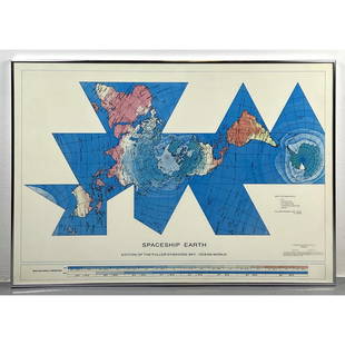
Sold2023Richard Buckminster Fuller Dymaxion World Map Print, 1980 FullerRichard Buckminster Fuller Dymaxion World Map Print, 1980 Fuller Dimensions: H: 22.5 inches: W: 34.5 inches --- -- We offer curbside delivery to NYC, Manhattan, Close Brooklyn, Hoboken about a week afSee Sold Price
Sold2020Framed Antique Map Orbis Vetus, Robert De VaugondyItem/Description: Old print. Map of the world by Robert de Vaugondy from 1752. Orbis vetus in utraque continente : In both the old continent / world map / Vaugondy 1752. Material: Print framed under gSee Sold Price
Sold2022Antique Map - Map of South America - Map of Brazil - George SwanstonInteresting antique map from ‘A Gazetteer of the World or Dictionary of Geographical Knowledge’ by A. Fullarton & Co. Technique: Hand colored steel engraving. Date: 1858. Artist: George HSee Sold Price
Sold2022Antique Map - Map of Europe - Map of Wales - Milford Haven - SwanstonInteresting antique map from ‘A Gazetteer of the World or Dictionary of Geographical Knowledge’ by A. Fullarton & Co. Technique: Hand colored steel engraving. Date: 1858. Size: 10”See Sold Price
Featured5 days LeftJasper52World War 2. Guadalcanal Campaign. October & November 1942 Operations 1959 mapUS$15
5 days LeftJasper52World War 2. Guadalcanal Campaign. August & September 1942 Operations 1959 mapUS$15
5 days LeftJasper52World War 2. Guadalcanal Campaign. Landing 7 Aug 1942 & Concurrent Ops 1959 mapUS$15
4 days LeftJasper521738 RUSSIA SIBERIA & GREAT TARTARY Description illustrated ANTIQUE in ENGLISHUS$950
Jun 22Trillium Antique Prints & Rare BooksMunster, pub. 1614 - View of Tours in Touraine, FranceUS$50
Jun 22Trillium Antique Prints & Rare BooksMunster, pub. 1614 - View of Sion (Sitten), SwitzerlandUS$50
Jun 22Trillium Antique Prints & Rare BooksMunster, pub. 1614 - Diagram of Horizon, Parallels, et al.US$50
14 hrs LeftTrillium Antique Prints & Rare BooksPrevost - Map of the World (An Essasy of a New and Complete Map containing the known parts of theUS$50
Jun 22Trillium Antique Prints & Rare BooksHarris - Map of the World (With Australia and part of New Zealand)US$75(1 bid)
5 days LeftJasper52Marianas April-July 1944. World War 2. Saipan Guam. Pacific Ocean 1961 old mapUS$8
5 days LeftJasper52Bismarck Archipelago New Guinea New Britain 1943/4. Ports. World War 2 1961 mapUS$8
5 days LeftJasper52New Guinea-Solomon Islands 1942/3. Pacific Campaign. World War 2 1961 old mapUS$10
5 days LeftJasper52World War 2. Guadalcanal Campaign 7-8 Aug 1942 Tulagi Landing Schedule 1959 mapUS$15
5 days LeftJasper52World War 2. Guadalcanal Campaign 7-8 Aug 1942 Landing. Henderson Field 1959 mapUS$15
5 days LeftJasper52MELANESIA. New Caledonia. Comboui-Noumea. WW2 ROYAL NAVY INTELLIGENCE MAP 1944US$10
Featured5 days LeftJasper52MELANESIA. New Caledonia. Pam-Ouaco. WW2 ROYAL NAVY INTELLIGENCE MAP 1944US$10
14 hrs LeftTrillium Antique Prints & Rare BooksChatelain - Pair of Engravings related to Mexico City & PanamaUS$75