Sold2022Large Collection of Books Including Hammonds World AtlasThe World Turned Upside Down, Eastern Mysteries and moreSee Sold Price
Sold2018'39 "COLLIER'S WOLD ATLAS AND GAZETTEER" HARDCOVER1939 edition of "Collier's World Atlas and Gazetteer" large hardcover book. Measures approx. 14 1/2" height x 11 1/4" width x 1 1/8" depth.See Sold Price
Sold2023Large Books on History Cartoons or ArtistsCollection of three Webster’s Dictionary’s - Third New International Versions volumes 1, 2, and 3, a Medallion World Atlas, two Norman Rockwell books, an antique Book on Queen Victoria aSee Sold Price
Sold2020Large Victorian Seaweed HerbariumUnited States, ca. 19th century. Signed "L. Swift." Large folio-size book titled "Algae" and filled with numerous specimens of seawood, some eccentrically arranged to form wreaths, buildings, monumentSee Sold Price
Sold20231849 German ATLAS MAPS Heinrich Dittmar Max Frommann Greece Italy Holy Land1849 German ATLAS MAPS Heinrich Dittmar Max Frommann Greece Italy Holy Land An impressive 19th-century German world atlas! This oblong atlas contains 14 stunning maps by Heinrich Dittmar and MaximilliSee Sold Price
Sold2021Collection of 9 World History BooksCollection of 9 large historical books, coffee table sized. Includes atlases, Nat Geo. books, and a desert photography book by David Muench. *Books will be boxed and shipped Media Mail.See Sold Price
Sold2019Civil War Hand Colored Print Harpers Woodcut NewRemoved from a large bound book of Harpers Woodcut prints from late 19th or early 20th century. Professionally hand colored. Titled New Orleans in 1862 the Federal Fleet at Anchor in the River, AprilSee Sold Price
Sold2023Magazines and Sheet MusicLarge lot of early 20th Century sheet music, 1935 Almanac, 1953 Hammond World Atlas, two Newsweek magazines chronicling the death of Princess Diana, vintage Life Magazines, and Walter Foster art instrSee Sold Price
Sold2019Malaya 1911-1922 Pair of Maps of the East IndiesBoth titled "Malay Archipelago" Large Lithograph Maps Published 1922 by The Times, London for "The Times Survey Atlas of the World" Maps by John George Bartholomew of the Edinburgh Geographical InstitSee Sold Price
Sold20231885 Atlas MAPS George Crams Unrivaled World Cerography Cartography HUGE FOLIO1885 Atlas MAPS George Crams Unrivaled World Cerography Cartography HUGE FOLIO A scarce, 19th-century atlas that showcases the best of George F. Crams cerographic color maps of the world. George F. CrSee Sold Price
Sold2018World Atlas RAND Mc NALLYWorld Atlas RAND Mc NALLY 1937. It has copy Ptolemy's Map of the World originally executed in Second Century engraved at ULM in 1482. Book measurement approximate: 14 x 11 In. Shipping cost: $15.00 exSee Sold Price
Sold2019THE SACRED HISTORY OF THE WORLDThree volume 19th century ca. 1833 set of leather bound books titled: THE SACRED HISTORY OF THE WORLD as displayed in the creation and subsequent events to the DULUGE bu Sharon Turner. LONDON : LongmaSee Sold Price
Sold2022Desirable map of Colorado from huge, scarce McNally atlasOne of the best maps of Colorado to be produced in the 19th century. From Rand, McNally’s 1897 Indexed Atlas of the World, a scarce atlas with beautiful, large format maps. Exquisite detail withSee Sold Price
Sold2021Large Group of Books on History and TravelLarge Group of Books on History and Travel, including 'Atlas of New York', 'The History of England' by David Hume, and other books on world history and travel, appx. 35 books All books sold "as is." NSee Sold Price
Sold20191800 Geography ATLAS MAPS John Walker India Asia World1800 Geography ATLAS MAPS John Walker India Asia World Map John Walker’s ‘Elements of Geography’ is an incredibly late 18th-century English atlas known for its impressive folding maps. This atlaSee Sold Price
Sold20231854 MAPS Atlas 1ed World in Middle Ages CRUSADES Rome Ottoman Medieval Koeppen1854 MAPS Atlas 1ed World in Middle Ages CRUSADES Rome Ottoman Medieval Koeppen Adolph Ludwig Koeppens “World in the Middle Ages” is a rare, 19th-century perspective on the state of the woSee Sold Price
Sold20191776 map of France by Zatta w/huge marginsReserve Reduced! "Lovely and large double-page copperplate engraved map of France from the most comprehensive world atlas produced in Italy in the 18th century. Original hand-color in outline with lovSee Sold Price
Sold2020Early Coltons atlas of the world vol. IThis old atlas is large and measures 16.5in x 18.75in overall. The book should be rebound and does have some ware on the edges. Maps are dated 1856. There are many antique maps inside and they range iSee Sold Price
Sold2022GROUP OF WOODENWARE AND ETC.Late 19th and early 20th centuries. Five wooden pieces including rolling pin and spools. "British North Borneo" and "Atlas of the World" books. And a brass hot water kettle, 11.5"h.See Sold Price
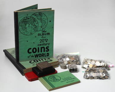
Sold2019Large collection world coinsLarge collection world coins, 20th c., (4) 20th century Coins of the World albums, partially filled, 4 pages per album; (1) album titled "Liberty Standing Half Dollars but containing 17 Polish coins;See Sold Price
Sold2022A KEYSTONE STEREOGRAPHIC LIBRARY SET AND A VIEWERA vintage Keystone stereographic library set titled Tour of the World, containing cards in book-like folios. Volumes 1-2, 5-6. Circa the 1930s. Go with a footed stereoscope viewer. The large collectioSee Sold Price
Sold20181850 McDowall Diamond Maps ATLAS Geography England1850 McDowall Diamond Maps ATLAS Geography England Scotland Ireland World Color A collection of 19th-century McDowall maps. These four maps are extremely desirable, hand-colored views. Maps include: �See Sold Price
Sold20221782 ATLAS MAPS Expilly Geography Voyages Travel World America Asia Africa1782 ATLAS MAPS Expilly Geography Voyages Travel World America Asia Africa Jean-Joseph Expilly was an 18th-century French geography and historian who published numerous works on cosmography, history oSee Sold Price
2 days Left1st Source ConsignmentJohn Gould & Henry Constantine Richter Birds of England Pheasant PrintUS$300
24 hrs LeftJasper521736 LARGE MAP OF SILESIA POLAND SAGANENSIS antique 25 x 4 3/4" Duchy of KrnovUS$260
5 days LeftTrillium Antique Prints & Rare BooksBraun & Hogenberg, pub. 1575 - View of Delft, NetherlandsUS$100
5 days LeftTrillium Antique Prints & Rare BooksBraun & Hogenberg, pub. 1575 - View of Ostia, ItalyUS$100(1 bid)
5 days LeftTrillium Antique Prints & Rare BooksBraun & Hogenberg, pub. 1575 - Views in the Middle East: Aden, Mombasa, Kilwa, & SofalaUS$100(1 bid)
5 days LeftTrillium Antique Prints & Rare BooksBraun & Hogenberg, pub. 1575 - View of Alexandria, EgyptUS$100(1 bid)
5 days LeftTrillium Antique Prints & Rare BooksBraun & Hogenberg, pub. 1575 - View of Lyon, FranceUS$100
5 days LeftTrillium Antique Prints & Rare BooksBraun & Hogenberg, pub. 1575 - View of Chester, EnglandUS$100
3 days LeftNY Elizabeth DENIS SAUVAGE'S 1581 HISTORY OF FRANCE: AN ANTIQUE VELLUM BOUND FOLIO FROM THE 16TH CENTURYUS$50
Jun 29JM Hobby Supply and Railroad Artifact AuctionsMilwaukee Road RR Book-Hiawatha-First of the SpeedlinersUS$15(2 bids)
Featured2 days LeftJasper52Johnson's Venezuela, New Granada, Ecuador, Peru, Bolivia, Chile, Guiana 1861 mapUS$85
6 days LeftJames Auctioneers LondonOsbourne Gemstone World Globe Atlas On Brass Stand-Large Edition!-Rrp £2k.£400


![[MAP]. ORTELIUS, Abraham. Aevi Veteris, Typus Geographicus. 1601. (1 of 3)](https://p1.liveauctioneers.com/197/329395/177650532_1_x.jpg?height=282&quality=70&version=1715364962)


