Sold2023Sale & Psalmanazar C1750 Map. Indelicia, Rhaetia & Noricum"The Countries of Vindelicia, Rhaetia & Noricum" Copper Plate Published 1747-68, London for "An Universal history, from the earliest account of time..." by George Sale, George Psalmanazar et al. PaperSee Sold Price
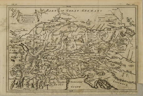
Sold2023Sale & Psalmanazar C1750 Map. The Countries of Vindelicia, Rhaetia & NoricumCopper Engraved Map Published 1747-68, London for "An Universal history, from the earliest account of time..." by George Sale, George Psalmanazar et al. Paper Size: 12.5 x 8 inch (32 x 20cm) Good CondSee Sold Price
Sold2023Sale & Psalmanazar C1750 Map. Pannonia Moesia Davia and Illyricum Turkey GreeceCopper Plate Published 1747-68, London for "An Universal history, from the earliest account of time..." by George Sale, George Psalmanazar et al. Paper Size: 12.5 x 8 inch (32 x 20cm) Good ConditionSee Sold Price
Sold2023Sale & Psalmanazar C1750 Map. Retreat of the ten thousand Greeks XenophonCopper Plate Published 1747-68, London for "An Universal history, from the earliest account of time..." by George Sale, George Psalmanazar et al. Paper Size: 12.5 x 9 inch (32 x 23cm) Good ConditionSee Sold Price
Sold2023Sale & Psalmanazar C1750 Map. Syria after ye death of Alexander the GreatCopper Plate Published 1747-68, London for "An Universal history, from the earliest account of time..." by George Sale, George Psalmanazar et al. Paper Size: 12.5 x 8.5 inch (32 x 22cm) Good ConditionSee Sold Price
Sold2023Sale & Psalmanazar C1750 Map. Arabia Petraea and DesertaCopper Plate Published 1747-68, London for "An Universal history, from the earliest account of time..." by George Sale, George Psalmanazar et al. Paper Size: 13 x 8.5 inch (33 x 22cm) Some text offsetSee Sold Price
Sold2023Sale & Psalmanazar C1750 Map. Mavretania, Numidia, Gaetulia &c. N. AfricaCopper Plate Published 1747-68, London for "An Universal history, from the earliest account of time..." by George Sale, George Psalmanazar et al. Paper Size: 12.5 x 9 inch (32 x 23cm) Very minor toninSee Sold Price
Sold2023Sale & Psalmanazar C1750 Map. Libya interior, Garamantum et MelanogaetulorumCopper Plate Published 1747-68, London for "An Universal history, from the earliest account of time..." by George Sale, George Psalmanazar et al. Paper Size: 13 x 9.5 inch (33 x 24cm) Very minor offseSee Sold Price
Sold2024Sale & Psalmanazar 1779 Map. Ancient Egypt with Pyramids"A Map of Antient Egypt" Copper Enngraved Map Published 1779, London for "An Universal history, from the earliest account of time..." by George Sale, George Psalmanazar et al. Folds as issued. Paper SSee Sold Price
Sold2024Sale & Psalmanazar 1779 Map. Syria after the Death of Alexander the GreatCopper Enngraved Map Published 1779, London for "An Universal history, from the earliest account of time..." by George Sale, George Psalmanazar et al. Folds as issued. Paper Size: 12.5 x 8 inch (32 xSee Sold Price
Sold2024Sale & Psalmanazar 1779 Map. Paradise Mount Ararat & Babel. Holy LandCopper Enngraved Map Published 1779, London for "An Universal history, from the earliest account of time..." by George Sale, George Psalmanazar et al. Folds as issued. Paper Size: 16 x 13 inch (40 x 3See Sold Price
Sold2023Sale & Psalmanazar C1740 Map. Garden of Eden & Plain of Shinaar, Holy Land"A Map of the most probable Place of the Garden of Eden, Plain of Shinaar, and Mountain where the Ark rested, according to this History" Copper Engraved Map Published 1736-44, London for "An UniversalSee Sold Price
Sold2023Sale & Psalmanazar C1740 Map. Egypt & Arabia"A Map of Ancient Egypt, and it's circumadjacencies according to this History" Copper Engraved Map Published 1736-44, London for "An Universal history, from the earliest account of time..." First andSee Sold Price
Sold2023Sale & Psalmanazar C1740 Map of the Tibes of Israel, Holy Land"A Map of the Divisions & Situations of the Tribes of the Canaanites, Moabites, Ammonites, Midianites, Edomites, Amalekites &c..." Copper Engraved Map Published 1736-44, London for "An Universal histoSee Sold Price
Sold2018Persia Iran C1750 Lot of 11 Copper Plates. PersepolisCopper Plates Published 1747-68, London for "A Universal history, from the earliest account of time" by George Sale, George Psalmanazar et al. Folds as issued. Paper Size: Up to 14.5 x 12.5 inch (37 xSee Sold Price
Sold20201750 c. Map of Eastern Alps Region in Ancient Times --Title: 1750 c. Map of Eastern Alps Region in Ancient Times -- The Countries of Vindelicia, Rhaethia & Noricum Cartographer: G Sale et al Year/Place: 1750 c., London Size: 7.8 X 11.8 in. Additional InfSee Sold Price
Sold2022San Mateo Co., Cal., Tide Lands at auction 1871Heading: (California - San Mateo County) Author: Allardt, Geo. F., Surveyor Title: Sale Map No. 9. Salt Marsh and Tide Lands situate in the County of San Mateo, State of California. To be sold at publSee Sold Price
Sold2022Bowen, Emanuel Collection of engraved maps, c.1750-65Bowen, Emanuel Collection of engraved maps, c.1750-65 including: A New and Accurate Map of China; A New and Accurate Map of the Empire of Japan; Turky in Asia, Arabia, etc.; A New and Accurate Map ofSee Sold Price
20211884 QURAN George Sale English Koran MAP Islam Mecca1884 QURAN George Sale English Koran MAP Islam Mecca Saudi Arabia Muslim George Sale’s English translation of the Quran has long been the best and most important English version of the Quran. In facSee Sold Price
Sold20204 Emigrant Documents and BroadsideIncludes railway map, acres for sale posting, constitution of Jefferson County and lower railway rates advertising. Some tears to map.See Sold Price
Sold2022Map of San Francisco Tidelands for sale, 1869Heading: -1869 Author: Allardt, Geo. F., Surveyor Title: Map No. 3 of Salt Marsh and Tide Lands Situate in the City & County of San Francisco. To be sold at Public Auction, by order of the Boards of TSee Sold Price
Sold2022Plan de Paris 1927 Made for Washington Sq. BookPlan de Paris map by Ilonka Karasz printed for sale at the Washington Square Bookshop in 1927. Measures 27.5 in. x 36 in. and folds to 14 in. x 9 in. Loose in a leatherette folio. Color with gilt on tSee Sold Price
Sold2022(ADRIATIC SEA.) Laurent Fries; after Martin Waldseemuller. Europae Tabula Quinta Continet Rhetiam &(ADRIATIC SEA.) Laurent Fries; after Martin Waldseemuller. Europae Tabula Quinta Continet Rhetiam & Vindeliciam, Noricum... Dalmatiam. Double-page woodcut Ptolemaic map of Italy and Dalmatia. 15¾See Sold Price
Sold20211923 Insurance Map of Hudson New York, Hardcover Folio1923 Insurance Map of Hudson New York, Hardcover Folio. Endpapers marked by Edgar J. Rossman, insurance agent. Maps are in color, with a brown paper covered boards and brown cloth spine. Label on fronSee Sold Price
Jun 01RbfineartsHistorical Map of the State of Kentucky by Karl Smith 1933 Daniel Boone & Companions ViewUS$20(1 bid)
Jun 01RbfineartsHistorical Map of the Chesapeake Bay By Edwin Tunis Published By The National Brewing Co.US$20(1 bid)
Jun 15Riverfront Auctions'1785 Bocage Map of the City of Athens in Ancient Greece' Par M. Barbié du BocageUS$5(1 bid)
Jun 08Connoisseur AuctionsEarly 1900's Railway Service Map, Illinois, Ohio, Indiana, Kentucky, TennesseeUS$20(1 bid)
Jun 07Freeman's | HindmanBELLIN, Jacques-Nicolas. Carte Reduite de L'Ocean Oriental ou Mer Des Indies. Paris, 1757. SecondUS$150
Jun 29JM Hobby Supply and Railroad Artifact AuctionsFlorence & Cripple Creek RR Public Timetable-September 1894US$400
Jun 07Freeman's | Hindman[HARDY, Thomas]. -- WINDLE, C.A. The Wessex of Thomas Hardy. Edmund H. New, illustrator. 1902.US$200
Jun 05TimeLine Auctions Ltd.Archaeological Books - Ancient Egyptian Research Discoveries - Various Titles£5


![[HARDY, Thomas]. -- WINDLE, C.A. The Wessex of Thomas Hardy. Edmund H. New, illustrator. 1902. (1 of 3)](https://p1.liveauctioneers.com/197/329395/177650387_1_x.jpg?height=282&quality=70&version=1715364962)


