Sold2016MATHEW CAREY (AMERICAN, 1760-1839) MAP OF DELAWAREMATHEW CAREY (AMERICAN, 1760-1839) MAP OF DELAWARE, hand-colored engraving on paper, titled "Delaware from the best Authorities", engraved by William Barker, published Philadelphia, 1795. Modern frameSee Sold Price
Sold2022MAP: "An Accurate Map of Hindostan and India", from the best Authorities, 1795, published by MatthewMAP: "An Accurate Map of Hindostan and India", from the best Authorities, 1795, published by Matthew Carey (1760- 1839), Philadelphia, J.T. Scott sculp., engraved for Carey's American Edition of GuthrSee Sold Price
Sold2024Carey, pub. 1796 - Map of the State of MarylandThis fine map engraving is from one of the ealiest American atlases published in the states: Mathew Carey's General Atlas. The work was published in Philadelphia by Carey in 1796. It was an importantSee Sold Price
Sold2016Early Map of The Michigan Territory by CareyThe Upper Territories of the United States, 1814. Matthew Carey (1760-1839). Engraved map with original hand color in outline. Philadelphia, 1814. 22 x 17 1/4 inches sheet. The map reflects a very earSee Sold Price
Sold20231795 Map of South American by Mathew Carey, Philadelphia16.5 x 21.5 inches, sight. Framed, 21.5 x 27 inches. Condition reports are not available for the items in this catalog. These are antique and vintage items, and will show signs of use and wear. We havSee Sold Price
Sold2019United StatesTitle: United States Publication Date: c1805 Cartographer: CAREY, MATHEW ? Publisher: Size: 6.1Height - 7.1Width Anonymous pocket map, possibly from Carey's American Pocket atlas of 1805. Foxed and brSee Sold Price
Sold2024Carey, pub. 1796 - Map of the Tennassee State formerly part of North Carolina (Tennessee)This fine map engraving is from one of the ealiest American atlases published in the states: Mathew Carey's General Atlas. The work was published in Philadelphia by Carey in 1796. It was an importantSee Sold Price
Sold2023MAP, Southern USA, CareySouthern United States. Mathew Carey, Georgia, from the Latest Authorities, from Carey's American Atlas of Guthrie's Geography, 1795 (published). Black & White. This scarce and significant map coversSee Sold Price
Sold2024Carey, pub. 1796 - A Chart of the West IndiesThis fine map engraving is from one of the ealiest American atlases published in the states: Mathew Carey's General Atlas. The work was published in Philadelphia by Carey in 1796. It was an importantSee Sold Price
Sold2018Delaware.Title/Content of Map: Delaware. Date: 1814 Cartographer: CAREY, MATHEW/A. DOOLITTLE Size: 7.75X5.75 From the 4th edition of Carey's American Pocket Atlas. With text. Browned. Please note that this lotSee Sold Price
Sold2023First state of an important map of the Trans-Mississippi WestMathew Carey's map, Missouri Territory formerly Louisiana, is one of the seminal maps of the period and the first atlas map to provide the cartographic detail derived from the return of the Lewis & ClSee Sold Price
Sold2021State of TN Map, M. Carey, 1814THE STATE OF TENNESSEE map, published by Mathew Carey in Carey's General Atlas, Improved and Enlarged, Philadelphia, 1814. Copperplate engraving with hand coloring depicting the state of Tennessee witSee Sold Price
Sold2024Carey, pub. 1814 - Map of the State of TennesseeThis engraved map is from Mathew Carey's General Atlas, improved and enlarged: being a collection of maps of the world and quarters, their principal empires, kingdoms, &c. The work was published in PhSee Sold Price
Sold2023Rare map of Upper Territories by Mathew Carey, 1814Early and rare map of the old Northwest Territory. In this map the area of Michigan has yet to be understood. The extents of Saginaw Bay and Green Bay are also more or less guessed at. The map reflectSee Sold Price
Sold2023KENTUCKY, REDUCED FROM ELIHU BARKER'S LARGE MAPPublication Date: 1795 Title: KENTUCKY, REDUCED FROM ELIHU BARKER'S LARGE MAP Cartographer: BARKER, ELIHU & W. Publisher: CAREY, MATTHEW Height: 9.4 Width: 20.2 Engraved for Carey's American Edition oSee Sold Price
Sold2022MAPS IN BOOK, Atlases, CareyCarey's Famous 1814 General Atlas. Atlases. Mathew Carey, Carey's General Atlas, Improved and Enlarged: Being a Collection of Maps of the World and Quarters, Their Principal Empires, Kingdoms, &c., 18See Sold Price
Sold2024Ohio copy of Mathew Carey’s 1796 GENERAL ATLASCarey, Mathew (publisher). CAREY’S GENERAL ATLAS. Philadelphia: Printed by Mathew Carey, May 1, 1796. FOLIO (14.75 x 9.5 inches), COMPLETE AS PUBLISHED (including a Rare Map of The United States bySee Sold Price
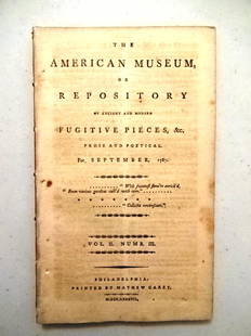
Sold20211787 Magazine First Printing of ConstitutionThe American Museum or Repository of Ancient and Modern Fugitive Pieces & c Prose and Poetical For September 1787. Published at Philadelphia by Mathew Carey MDCCLXXXVII. Vol. II Number III. COMPLETE iSee Sold Price
Sold20211787 Magazines Federalist Papers ConstitutionThe November and December 1787 issue of "The American Museum or Repositoryof Ancient and Modern Fugitive Pieces…..", Volume II Numbers V and VI, printed at Philadelphia by Mathew Carey, MDCCLXXXVII.See Sold Price
Sold20231795 Carey's Am Ed of Guthries Impr Geography1795 Matthew Carey "Carey's American Edition of Guthrie's Geography Improved", 1st edition of the 1st American printed atlas, 43 of 44 maps remaining, incl Doolittle's Vermont, Virginia, the CarolinasSee Sold Price
Sold2016c. 1760s, Hand-Colored World Map, “Mappa Mondo”Historic Maps 1760 Hand-Colored World Map, Siena Presso Pazzini Carli c. 1760s, Hand-Colored World Map, “Mappa Mondo,” Printed & Colored by Siena Presso Pazzini Carli, Choice Very Fine. A fine GobSee Sold Price
Sold2022c 1760 Northern Colonies French + Indian War MapHistoric Maps Louisiana & Florida French & Indian War Era Map c. 1760 c. 1760 French & Indian War Era, Hand-Colored Map of Pennsylvania and New England titled, "Carte de la Partie Nord, Des Etats UnisSee Sold Price
Sold20161760 French + Indian War Map Louisiana + FloridaHistoric Maps French & Indian War Era Map of Louisiana & Florida c. 1760 French & Indian War Era, Historic Map Titled, “Carte de la Louisiane, et de la Floride. Par M. Bonne, Ingenieur-Hydrographe dSee Sold Price
Sold20231862 Civil War, Coltons New Topographical Map of The States of Virginia, Maryland and DelawareHistoric Maps 1862 Civil War "Colton's New Topographical Map of The States of Virginia, Maryland and Delaware" Hardcover Folio 1862-Dated Civil War Period, Hand-colored 45.25" x 31.5" Folding Map titlSee Sold Price
Jun 08Simpson Galleries, LLC.J.H. Young (1792-1870) AN AMERICAN FEDERAL PERIOD MAP, "Mitchell's Travellers Guide Through theUS$500
1 day LeftRoyal Treasures Warehouse LLCIndians of the USA Native American Tribes Historical Map PosterUS$50(1 bid)
7 days LeftFreeman's | HindmanMURCHISON, Roderick Impey, Sir. The Silurian System. 1839. COMPLETE WITH VERY RARE HAND-COLOREDUS$1,500
Jun 18DOYLE Auctioneers & AppraisersA block puzzle with maps of Europe, England, Ireland, Scotland, America and the WorldUS$100
Jun 08Simpson Galleries, LLC.JULIUS BIEN (1826-1909) AN AMERICAN CIVIL WAR RECONNAISSANCE MAP, "Map of Texas and Part of NewUS$100
Jun 08Early American History Auctions1720 Colonial Northumberland County Virginia Manuscript Deed and Map PlotUS$400
7 days LeftFreeman's | HindmanHOMANN, Johann Baptist. Amplissimae Regionis Mississipi Seu Provinciae Ludovicianae. Nuremburg, [caUS$400(1 bid)
Jun 23Schilb Antiquarian Rare Books1877 Geology Geography Surveys 1ed Nevada Wyoming Utah George Wheeler US West 2vUS$1