Sold2023Map of French Senegal and New Guinea 1727Framed map of French Senegal and New Guinea 1727 illuminated manuscript French framed- Nice condition.See Sold Price
Sold2020Rare Map New Guinea latest discoveries by DampierTitle: Rare Map New Guinea latest discoveries by Dampier Date/Period: 1744-1748. Materials: Copperplate engraved Dimensions: 16x9 3/4”. Subject. Map of discoveries by Dampier. New Guinea. SurroundSee Sold Price
Sold2017Myra Z Barnes: Vintage Map French Quarter, New OrleansTitle/Content of Map: 1942 Myra Z Barnes Map of French Quarter, New Orleans -- Le Vieux Carre de la Nouvelle Orleans Date Printed: 1942 Cartographer: Myra Z Barnes Size: 20.5 X 30.8 A very attractiveSee Sold Price
Sold201716TH C. MAP OF NEW GUINEA16th Century map of the coast identifying Sierra Leone by the Portuguese. Dimensions: (Frame) H 19.5" x W 23.75" (Sight) H 13.75" x W 19.5" Condition: Foxing to mat. Wear to frame.See Sold Price
Sold20211852 1ed Louisiana History MAP French Colonization1852 1ed Louisiana History MAP French Colonization New Orleans Charles Gayarre Charles Gayarré was a 19th-century American historian who is best remembered for his historical works relating to LouisiSee Sold Price
Sold20191942 Myra Z Barnes Map of French Quarter, New OrleansTitle/Content of Map: 1942 Myra Z Barnes Map of French Quarter, New Orleans -- Le Vieux Carre de la Nouvelle Orleans Date: 1942 ca. Cartographer: Myra Z Barnes Size: 20.5 X 30.8 in. A very attractiveSee Sold Price
Sold2017Barnes: Antique Map of French Quarter, New Orleans 1942Title/Content of Map: 1942 Myra Z Barnes Map of French Quarter, New Orleans -- Le Vieux Carre de la Nouvelle Orleans Date Printed: 1942 Cartographer: Myra Z Barnes Size: 20.5 X 30.8 in. Condition: VerSee Sold Price
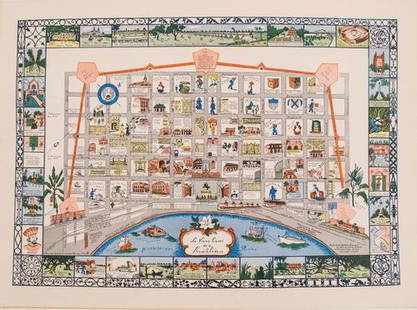
20191942 Myra Z Barnes Map of French Quarter, New OrleansTitle/Content of Map: 1942 Myra Z Barnes Map of French Quarter, New Orleans -- Le Vieux Carre de la Nouvelle Orleans Date: 1942 ca. Cartographer: Myra Z Barnes Size: 20.5 X 30.8 in. A very attractiveSee Sold Price
Sold20231942 Myra Z Barnes Map of French Quarter, New OrleansTitle/Content of Map: 1942 Myra Z Barnes Map of French Quarter, New Orleans -- Le Vieux Carre de la Nouvelle Orleans Date: 1942 ca. Cartographer: Myra Z Barnes Size: 20.5 X 30.8 in. A very attractiveSee Sold Price
Sold2017Myra Z Barnes: Map of French Quarter, New Orleans, 1942Map: 1942 Myra Z Barnes Map of French Quarter, New Orleans -- Le Vieux Carre de la Nouvelle Orleans Cartographer: Myra Z Barnes Year / Place: 1942 Map Dimensions: 20.5 X 30.8 Condition: Very Good. CriSee Sold Price
Sold20221942 Myra Z Barnes Map of French Quarter, New OrleansTitle: 1942 Myra Z Barnes Map of French Quarter, New Orleans -- Le Vieux Carre de la Nouvelle Orleans Cartographer: Myra Z Barnes Year/Place: 1942 ca. Dimensions: 20.5 X 30.8 in. Description: A very aSee Sold Price
Sold20231942 Myra Z Barnes Map of French Quarter, New Orleans -- Le Vieux Carre de la Nouvelle OrleansTitle: 1942 Myra Z Barnes Map of French Quarter, New Orleans -- Le Vieux Carre de la Nouvelle Orleans Cartographer: Myra Z Barnes Year / Place: 1942 ca. Map Dimension (in.): 20.5 X 30.8 in. A very attSee Sold Price
Sold2017Myra Z Barnes Map of French Quarter, New Orleans,1942Title: 1942 Myra Z Barnes Map of French Quarter, New Orleans Cartographer: Myra Z Barnes Published: 1942 or later Measurements: 20.5 X 30.8 in. Le Vieux Carre de la Nouvelle Orleans. A very attractiveSee Sold Price
Sold20201942 Myra Z Barnes Map of French Quarter, New OrleansTitle: 1942 Myra Z Barnes Map of French Quarter, New Orleans -- Le Vieux Carre de la Nouvelle Orleans Cartographer: Myra Z Barnes Year / Place: 1942 ca. Map Dimension (in.): 20.5 X 30.8 in. A very attSee Sold Price
Sold20221942 Myra Z Barnes Map of French Quarter, New Orleans -- Le Vieux Carre de la Nouvelle OrleansTitle: 1942 Myra Z Barnes Map of French Quarter, New Orleans -- Le Vieux Carre de la Nouvelle Orleans Cartographer: Myra Z Barnes Year/Place: 1942 ca. Dimensions: 20.5 X 30.8 in. Description: A very aSee Sold Price
Sold20201942 Myra Z Barnes Map of French Quarter, New OrleansTitle/Content of Map: 1942 Myra Z Barnes Map of French Quarter, New Orleans -- Le Vieux Carre de la Nouvelle Orleans Date: 1942 ca. Cartographer: Myra Z BarnesSize: 20.5 X 30.8 in. A very attractive lSee Sold Price
Sold20221942 Myra Z Barnes Map of French Quarter, New Orleans -- Le Vieux Carre de la Nouvelle OrleansTitle: 1942 Myra Z Barnes Map of French Quarter, New Orleans -- Le Vieux Carre de la Nouvelle Orleans Cartographer: Myra Z Barnes Year / Place: 1942 ca. Map Dimension (in.): 20.5 X 30.8 in. A very attSee Sold Price
Sold20181942 Myra Z Barnes Map of French Quarter, New OrleansReserve Reduced! Title/Content of Map: 1942 Myra Z Barnes Map of French Quarter, New Orleans -- Le Vieux Carre de la Nouvelle Orleans Date: 1942 ca. Cartographer: Myra Z Barnes Size: 20.5 X 30.8 in. ASee Sold Price
Sold20211942 Myra Z Barnes Map of French Quarter, New OrleansTitle: 1942 Myra Z Barnes Map of French Quarter, New Orleans -- Le Vieux Carre de la Nouvelle Orleans Cartographer: Myra Z Barnes Year / Place: 1942 or later Map Dimension (in.): 20.5 X 30.8 A very atSee Sold Price
Sold20231942 Myra Z Barnes Map of French Quarter, New Orleans -- Le Vieux Carre de la Nouvelle OrleansTitle: 1942 Myra Z Barnes Map of French Quarter, New Orleans -- Le Vieux Carre de la Nouvelle Orleans Cartographer: Myra Z Barnes Year / Place: 1942 ca. Map Dimension (in.): 20.5 X 30.8 in. A very attSee Sold Price
Sold20191942 Myra Z Barnes Map of French Quarter, New OrleansTitle: 1942 Myra Z Barnes Map of French Quarter, New Orleans -- Le Vieux Carre de la Nouvelle Orleans Date: 1942 ca. Cartographer: Myra Z Barnes Size: 20.5 X 30.8 in. Additional Information: A very atSee Sold Price
Sold20181942 Myra Z Barnes Map of French Quarter, New OrleansTitle/Content of Map: 1942 Myra Z Barnes Map of French Quarter, New Orleans -- Le Vieux Carre de la Nouvelle Orleans Date: 1942 ca. Cartographer: Myra Z Barnes Size: 20.5 X 30.8 in. A very attractiveSee Sold Price
Sold2022Carl Rose Original Illustrations Collection of 3 MapsCarl Rose Original illustrations collection of 3 maps. The Philippines, New Guinea and Maine Carl Rose, 1903 – 1971 was an American cartoonist whose work appeared in The New Yorker, Popular SciSee Sold Price
Sold2020EARLY FRENCH MAP OF NEW ENGLANDHand-colored. Ca 1750-1760. Map in French. Map 14 1/2 x 12 1/2 inches. Fold marks and water stains. Overall 21 inches x 19 inches. Stains and cut down.See Sold Price
5 days LeftJasper52New Guinea & Papuan Archipelago. Solomon & Bismarck islands. THE TIMES 1900 mapUS$20
Jun 23East Coast Fine Arts LLC1777 US Revolutionary War Map French Brion de la Tour Theatre de GuerreUS$1,000
Jun 22Trillium Antique Prints & Rare BooksPrevost - Volume 16 with 31 Maps & Engravings (Including Map or Australia)US$200(1 bid)
5 hrs LeftTrillium Antique Prints & Rare BooksPrevost - Map of the World (An Essasy of a New and Complete Map containing the known parts of theUS$50
Featured5 days LeftJasper52POLYNESIA/PACIFIC ISLANDS. inc Sandwich/Hawaiian islands. RAPKIN/TALLIS 1851 mapUS$120
5 days LeftJasper52Bismarck Archipelago New Guinea New Britain 1943/4. Ports. World War 2 1961 mapUS$8
5 days LeftJasper52New Guinea-Solomon Islands 1942/3. Pacific Campaign. World War 2 1961 old mapUS$10
5 days LeftJasper52Isles de la Reine Charlotte. Nendo, Santa Cruz, Solomon Islands. BONNE 1788 mapUS$20
5 days LeftJasper52Isles de la Reine Charlotte. Nendo, Santa Cruz, Solomon Islands. BONNE 1790 mapUS$20
5 days LeftJasper52New Guinea & Papuan Archipelago. Solomon & Bismarck islands. THE TIMES 1895 mapUS$25
Jun 22Trillium Antique Prints & Rare BooksPrevost - Map of Australia (New Holland) with part of New ZealandUS$100
Featured5 days LeftJasper52British New Guinea. Solomon Islands New Hebrides Melanesia. STANFORD 1904 mapUS$110
5 days LeftJasper52South west Pacific Ocean Melanesia Polynesia ADMIRALTY sea chart 1875 (1968) mapUS$120