Sold2022Gene Summers (1926-2011) Coffee Table Edition 1 of 9, c. 2007 Walla Walla Foundry, USAGene Summers (1926-2011) Coffee Table Edition 1 of 9, c. 2007 Walla Walla Foundry, USA cast bronze, silver leaf signed 'G.R.S. 1/9 2007 WWF' H 17 x W 72 x D 48 inchesSee Sold Price
Sold2022Walla Walla Horsehair BridleVery unusual Washington State Prison made horsehair bridle, done in a mixture of braided two-tone leather and bold black and white hitched horsehair, with very uncommon incorperated bosal, and accenteSee Sold Price
Sold2024Lockwood Dennis "Stables, Walla Walla" (1995)Lockwood "Woody" Dennis (American, 1937-2012). "Stables, Walla Walla" oil on canvas, 1995. Signed on lower left and signed, dated, and titled on verso. A fabulous painting by American artist LockwoodSee Sold Price
Sold2023Deborah Butterfield (American, B 1947)Derby, 1985 Patinated bronze Numbered 5/5; signed, Editioned, marked "Walla Walla" underneath. Note: No apparent flaws or damage. 32 x 46 x 12 in.See Sold Price
Sold2021Authentic Medieval HelmetAuthentic medieval helmet. Measures 9.5 in. x 12.25 in. x 12 in. tall. Weighs 5.5 lbs. Provenance: From the estate of Clint Max Miller of Seattle and most recently Walla Walla. Clint was a history bufSee Sold Price
Sold2022Manuel Neri (1930-2021), BronzeManuel Neri (1930-2021) bronze bust of a female figure. Signed, dated (1984), numbered (1/6) and marked Walla Walla Foundry on underside. Dimensions: 4"h. Provenance: Estate of Roy DeForest, estate nuSee Sold Price
Sold2022James Reid Bison Bull Oil on Board Painting5" by 7" unframed. 10.5" by 12.5" framed. Title is "Bison Bull". Born in Walla Walla, Washington, he and his wife, Marian, live in Boise, Idaho. They have two grown sons. His ability in art was appareSee Sold Price
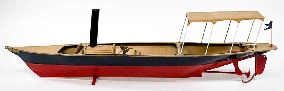
Sold2021Vintage Tin Wind-Up BoatVintage tin wind-up toy boat with key. Tested. Measures 22 in. x 4 in. x 5.5 in. Provenance: From the estate of Clint Max Miller of Seattle and most recently Walla Walla. Clint was a history buff andSee Sold Price
Sold2022Hercaimy Enterprises Silver Eagle Ingot [146057]Extremely rare ten ounce silver ingot trademarked Silver Eagles, issued by Hercaimy Enterprises of Walla Walla Washington. Octagonal, 51 mm. Hercaimy Enterprises operated as a coin shop business fromSee Sold Price
Sold2021Beggs Locomotive Ca. 1850Beggs locomotive circa 1850. Measures 11.5 in. x 2.75 in. x 5 in. tall Provenance: From the estate of Clint Max Miller of Seattle and most recently Walla Walla. Clint was a history buff and an avid anSee Sold Price
Sold201619th C. Native American Corn Husk Bag - Nez PerceNative American Indian, Columbia Plateau area, probably Nez Perce, possibly Yakama, Cayuse, Palouse, Walla Walla, or Umatilla, ca. late 19th to early 20th century CE. A finely woven, flat corn husk baSee Sold Price
Sold2021Vintage Brass Engine Locomotive ModelVintage brass engine locomotive model. Measures 6.5 in. x 4 in. x 5.25 in. Provenance: From the estate of Clint Max Miller of Seattle and most recently Walla Walla. Clint was a history buff and an aviSee Sold Price
Sold2021PL 287 EVENING ON THE COLUMBIA 1911 Copper PlateEDWARD S. CURTIS. Plate 287 Evening on the Columbia, 1910. 11.9x15.5" image on 14.1x17" copper plate. Plate date 1911. Plate 287 from Portfolio 8, The Nez Perces. Wallawalla. Umatilla. Cayuse. The ChiSee Sold Price
Sold2018Gall & Inglis' Map of the United StatesReserve Reduced! Item: Gall & Inglis' Map of the United States Date: 1850 Cartographer: MURPHY, W. Publisher: GALL & INGLIS Size (inches): 20.8X17 Map showing U.S. one tier beyond Miss.R., including ASee Sold Price
Sold2022(WEST.) Samuel Parker. Journal of an Exploring Tour Beyond the Rocky Mountains.(WEST.) Samuel Parker. Journal of an Exploring Tour Beyond the Rocky Mountains. Folding map, plate. 408 pages. 12mo, publisher's cloth; lacking front flyleaf, moderate foxing; early signature and lateSee Sold Price
Sold2021[PICTORIAL MAP] Ship the Sky Way Via Air Express. USA:[PICTORIAL MAP] Ship the Sky Way Via Air Express. USA: Dixie-Raymond, 1941. Map of the Railway Express Agency’s express air shipping service across the United States and beyond to Canada, AlaskaSee Sold Price
Sold2017Antique Map of Russia, 1792Antique Map of Russia - Carte Nouvelle De Moscovie Represente La Partie Septentrionle. This ornate antique map covers northern Russia, from the Arctic Ocean and Finland to just beyond the Petzora RiveSee Sold Price
Sold2022By rail from Buffalo to Chicago & beyondHeading: (United States) Author: Title: Map of the Lake Shore and Michigan Southern Railway and its connections: Compiled from the latest sources and showing the true location of each road Place PublSee Sold Price
Sold2022Scarce Texas map (eastern part) from Asher & Adams,County map of Eastern Texas extends from Louisiana west to beyond San Antonio and features the railroad system of that time. Features numerous railroads still in their infancy, along with proposed futSee Sold Price
Sold2022Asher & Adams' unique RR map of Texas, 1871County map of East Texas depicted in the unique Asher & Adams’ style, without roads to highlight the presence of railroads. Extends from Louisiana west to beyond San Antonio and features the raSee Sold Price
Sold20191869 Richardson Map of the Western US -- Map 1869 ofTitle/Content of Map: 1869 Richardson Map of the Western US -- Map 1869 of the Region Between the Mississippi and the Pacific, to Accompany Richardson's "Beyond the Mississippi". Date: 1869, HartfordCSee Sold Price
Sold2017Gentleman’s Magazine Map of the New Continent, 1758Map: A Map of the New Continent according to its greatest diametrical Length from the River la Plata to beyond the Lake of the Assiniboits Maker: Gentleman's Magazine Place & Date: London / 1758 Size:See Sold Price
Sold20209 Antiqe MapsIncludes: 1) A Map of a New Continent according to its Greatest Diametrical Length from the River la Plata to beyond the lake of Assiniboits. Gentleman's Magazine. London 1758. Eng. John Gibson afterSee Sold Price
Sold20161812 Handcolored Map Tribe of Manasseh Holy Land1812 Hand Colored Map of the Holy Land “The Tribe of Manasseh beyond Jordan”. Printed for Mathews and Leigh, measures 9 x 11.5”. Free shipping within the continental USSee Sold Price
3 days LeftThe Bidder AuctionsThe map of the railways in the Land of Israel - published by the Surveying Department of the BritishUS$30
2 days LeftCedarburg Auction & Appraisals LLCSet of Four 17th Century Maps Showing All of Spain and PortugalUS$450(2 bids)
2 days LeftCedarburg Auction & Appraisals LLCRare 1877 Double sided map of Milwaukee and WisconsinUS$80(6 bids)
Jun 07Freeman's | Hindman[MAP]. TODESCHI, Pietro. [Nova et Acurata Totius Americae Tabula auct. G.I. Blaeu] America quartaUS$5,000
6 days LeftSchilb Antiquarian Rare Books1887 Visions of Beyond SEANCES Occult Symbolism Indians Asylums Spirits GHOSTSUS$58(4 bids)
Jun 08Early American History Auctions1720 Colonial Northumberland County Virginia Manuscript Deed and Map PlotUS$400
Jun 09Austin Auction GalleryITALIAN SCHOOL PAINTING OF A LANDSCAPE WITH BRIDGE & MOUNTAIN BEYONDUS$800
Jun 07Freeman's | Hindman[MAP]. ORTELIUS, Abraham. Americae Sive Novi Orbis, Nova Descriptio. 1573.US$1,000(1 bid)
Jun 15Bazaar of PersiaPantera Dimebag Darrell Abbott Signature Guitar Pick Stage "Far Beyond Driven" tour -94US$300
3 days LeftAntiques Online AuctionsVintage Texas 1845 Map Printed in 1986, Compiled by John DavisUS$60(4 bids)
Jun 23Schilb Antiquarian Rare Books1977 JRR Tolkien 1st ed Silmarillion Lord of the Rings Middle Earth + MAPUS$21(3 bids)


![Hercaimy Enterprises Silver Eagle Ingot [146057]: Extremely rare ten ounce silver ingot trademarked Silver Eagles, issued by Hercaimy Enterprises of Walla Walla Washington. Octagonal, 51 mm. Hercaimy Enterprises operated as a coin shop business from](https://p1.liveauctioneers.com/2699/237264/122968893_1_x.jpg?height=310&quality=70&version=1644690635)


![[PICTORIAL MAP] Ship the Sky Way Via Air Express. USA:: [PICTORIAL MAP] Ship the Sky Way Via Air Express. USA: Dixie-Raymond, 1941. Map of the Railway Express Agency’s express air shipping service across the United States and beyond to Canada, Alaska](https://p1.liveauctioneers.com/928/200564/101543112_1_x.jpg?height=310&quality=70&version=1618323144)


![[MAP]. TODESCHI, Pietro. [Nova et Acurata Totius Americae Tabula auct. G.I. Blaeu] America quarta (1 of 1)](https://p1.liveauctioneers.com/197/329395/177650542_1_x.jpg?height=282&quality=70&version=1715364962)


![[MAP]. ORTELIUS, Abraham. Americae Sive Novi Orbis, Nova Descriptio. 1573. (1 of 2)](https://p1.liveauctioneers.com/197/329395/177650534_1_x.jpg?height=282&quality=70&version=1715364962)


![[MAP]. ORTELIUS, Abraham. Turcici Imperii Descriptio.1592. (1 of 2)](https://p1.liveauctioneers.com/197/329395/177650538_1_x.jpg?height=282&quality=70&version=1715364962)

![[MAP]. ORTELIUS, Abraham. Aevi Veteris, Typus Geographicus. 1601. (1 of 3)](https://p1.liveauctioneers.com/197/329395/177650532_1_x.jpg?height=282&quality=70&version=1715364962)


