Sold202318th Century Map Of Southern Africa & The Congo18th Century Map Of Southern Africa & The Congo. Titled "Carte du Royaume de Congo, du Monomotapa et de la Cafrerie. Dressee sur les Memoires les plus exacts & les observations les plus Nouvelles.// MSee Sold Price
Sold20211776 1ed History of Loango AFRICA Proyart Kakongo Congo1776 1ed History of Loango AFRICA Proyart Kakongo Congo Missionaries HUGE MAP Lievain Proyart was an 18th-century French author mostly known for his treatises on the Catholic Church. However, his mostSee Sold Price
Sold202018th c. map of Africa showing known kingdomsHeading: Author: Robert de Vaugondy, Gilles and Didier Title: L'Afrique dressée, sur les relations les plus recentes, et assujettie aux observations astronomiques Place Published: [Paris] Publisher:See Sold Price
Sold202218TH-CENTURY MAP OF AFRICA18TH-CENTURY MAP OF AFRICA: John Senex "Africa Corrected from the Observations of the Royal Society of London and Paris", published 1714. Frame Approx. 29.25" h x 40.25" w.See Sold Price
Sold202117TH / 18TH CENTURY MAP "ANTIENT AFRICA"Hand colored engraving with center fold. Titled "A New Map of The North Part of Antient Africa." Dimensions: (Frame) H 22" x W 26.5" (Sight) H 15" x W 19.5" Condition: Paper clean.See Sold Price
Sold2022A late 18th century map sampler depicting southern Scotland, England and WalesA late 18th century map sampler depicting southern Scotland, England and Wales Also including the east coast of Ireland and northern France, worked on a linen group and signed and inscribed 'Wrought iSee Sold Price
Sold202418th c. Hand Drawn Map of Africa18th c. hand drawn map of Africa. Signed ….Briggs. Sight 9 1/2" x 11 1/2", overall 11 1/2" x 13 1/2". Provenance: The Edward Herrmann Estate, Salisbury Connecticut.See Sold Price
Sold202318th Century English Engraved Map of AfricaBy T. Jefferies circa 1748. Nicely detailed map of Africa and its regions. Some yellowing and slight loss at the edges. H9 3/4" W11 1/4"See Sold Price
Sold2017EPHEMERASixteen pieces including ten 18th c. maps and moon charts of Africa, British America (Canada), South America, West Canada, Mexico, California and Texas, England, Finland, Bothnia, Aberdeen Shire, PolaSee Sold Price
Sold2016Fantastic Old Lulua African mask with Elaborate styleOld and well worn carved wooden African mask with an elaborate carved face and bead with a fancy headdress and painted accents. Lulua peoples, DRC / Congo, Africa. The mask itself measures 18 c 6 inchSee Sold Price
Sold201818th C. African Necklace of Carved Ostrich Egg Shell**Originally Listed At $100** Southern/Eastern Africa, probably San Bushmen, ca. mid 18th to early 19th century CE. A fine collection of hundreds of heishi-shaped, disc beads made from creamy white osSee Sold Price
Sold202412 pcs Southern Ephemera incl. TN/KY maps and Georgia 1797 map1st item: Late 18th C. American map of Georgia, extending to Mississippi with the Southern part of "Tennassee ", terminating at the Mississippi River. Depicts Natchez and "Alibama" (current day AlabamSee Sold Price
Sold2021"AFRICA", map belonging to the "Atlas Universel,"AFRICA", map belonging to the "Atlas Universel, dressé sur les meilleures cartes modernes", second half of the 18th century.Illuminated engraving (colour demarcations).Edition M. Remondini, VeniceSee Sold Price
Sold20181759 Barrow Geography Dictionary ATLAS MAPS Syria1759 Barrow Geography Dictionary ATLAS MAPS Syria Africa Coffee Tobacco HUGE FOLIO John Barrow was an 18th-century English naval historian remembered for his illustrated dictionaries. This tome from BSee Sold Price
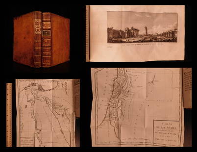
Sold20191799 Voyages in Syria & EGYPT Africa Illustrated MAPS1799 Voyages in Syria & EGYPT Africa Illustrated MAPS Sphinx Pyramids 2v Volney Constantin-François Volney, an 18th-century French philosopher known for his historical works on archaeology and travelSee Sold Price
Sold20201787 1st ed Voyages in Syria & EGYPT Africa Illustrated1787 1st ed Voyages in Syria & EGYPT Africa Illustrated MAPS Sphinx 2v Volney “The best expose of Ottoman Empire at the end of the 18th-century!” (Blackmer) Constantin-François Volney, an 18th-ceSee Sold Price
Sold2017Early Map of Georgia, John Payne, Circa 1810John Payne (American, 18th/19th century), "Georgia from the latest Authorities 1810"-1810/11. An early American engraved map of the Southern United States by mapmaker John Payne (American, 18th/19th cSee Sold Price
Sold20221751 ATLAS Geography MAPS South America USA Asia Africa Universal Gazetteer1751 ATLAS Geography MAPS South America USA Asia Africa Universal Gazetteer John Walkers Universal Gazetteer is a late 18th-century geographical dictionary and atlas filled with descriptions of countlSee Sold Price
Sold20181828 ATLAS MAPS Ancient & Modern Geography Asia Africa1828 ATLAS MAPS Ancient & Modern Geography Asia Africa Turkey Greece Delamarche Felix Delamarche was a well-known and important French cartographer from the 18th-century. His best and most widely usedSee Sold Price
Sold20231847 ATLAS 37 MAPS Geography Alexander the Great America Africa Delamarche1847 ATLAS 37 MAPS Geography Alexander the Great America Africa Delamarche Felix Delamarche was a well-known and important French cartographer from the 18th-century. This 1847 French atlas was publishSee Sold Price
Sold2021Eleven Antique Maps of EuropeEleven Antique Maps of Europe , 16th-18th c., incl. Ptolemy from 1541 (4); a Blaeu map of "Regno di Napoli", Hondius map of the Holy Land, de Wit map of Southern Spain, an undated manuscript map of MeSee Sold Price
Sold2016Lifesize 19th C. African Kongo Carved Stone HandSouthern Africa, Angola or Democratic Republic of the Congo, Kongo (Bakongo) peoples, 19th to early 20th century CE. This is a carved stone hand that was made to be resting on a lap; it is holding anSee Sold Price
Sold2023SOUTHERN AFRICA Monomotapa (Mutapa Kingdom) Cafrerie (Kaffraria) MALLET 1683 mapTITLE OF THE MAP: 'Monomotapa et la Cafrerie' (De L'Afrique) The map extends from a line across Africa from the Congo - southwards to the Cape of Good Hope. The Kingdom of Mutapa, sometimes referred tSee Sold Price
Sold20221782 ATLAS MAPS Expilly Geography Voyages Travel World America Asia Africa1782 ATLAS MAPS Expilly Geography Voyages Travel World America Asia Africa Jean-Joseph Expilly was an 18th-century French geography and historian who published numerous works on cosmography, history oSee Sold Price
Oct 17Rob Michiels AuctionsFrench or Southern Netherlands school: 'Tea ceremony', oil on canvas, 18th C.€2,400
5 days LeftArtelisted18th C. Geographie Moderene Historique et Politique: Les Isles de Sardaigne et de CorseUS$150
5 days LeftArtelisted18th C. Geographie Moderene Historique et Politique: Le Danemark Divisé par Provinces et DiocèsesUS$150
3 days LeftEast-Wing Estate Sales & Auction CompanyLate 18th C. Dutch Serpentine Chest of DrawersUS$160(2 bids)
3 days LeftConestoga Auction Company Division of Hess Auction GroupPhila., PA 18th C. Slip-Decorated Redware Bowl.US$50
3 days LeftConestoga Auction Company Division of Hess Auction GroupPhiladelphia, PA 18th C. Slip Redware Bowl.US$100
3 days LeftConestoga Auction Company Division of Hess Auction GroupPA Late 18th C. Painted Softwood Dower Chest.US$150


![18th c. map of Africa showing known kingdoms: Heading: Author: Robert de Vaugondy, Gilles and Didier Title: L'Afrique dressée, sur les relations les plus recentes, et assujettie aux observations astronomiques Place Published: [Paris] Publisher:](https://p1.liveauctioneers.com/642/162817/82203061_1_x.jpg?height=310&quality=70&version=1582924314)