Sold2023Williamson, Lieut. R. S. 1856 Map. California, New Mexico, Texas, Mexico"United States & Mexican Boundary Survery" Lithograph Map Published 1853-61, Washington for "Reports of explorations and surveys, to ascertain the most practicable and economical route for a railroadSee Sold Price
Sold2015Map of New Mexico & Utah by Colton, 1856 (Rare Find!)Original steel engraving by J.H. Colton, 1856. Very desirable map of the American Southwest. Map details the regions between California and Texas and between Oregon and Mexico. Covers territorial NewSee Sold Price
Sold2023Williamson, Lieut. R. S. 1856 Map. California - Tejon Pass & Canada de las Uvas"Geological Map of the Tejon Pass & Canada de las Uvas and the Vicinity. Including the Pass of San Francisco & Williamsons Pass"Lithograph Map Published 1853-61, Washington for "Reports of explorationSee Sold Price
Sold2023Williamson, Lieut. R. S. 1856 LG HC Map. California - First Geological Map"Geological Map of a Part of the State of California" Explored in 1855 by Lieut R. S. Williamson. Prepared to accompany the Report of William P. Blake. THE FIRST GEOLOGY MAP OF CALIFORNIA. Hand ColoreSee Sold Price
Sold2023Williamson, Lieut. R. S. 1856 Map. Vicinity of San Francisco California"Geological Map of the Vicinity of San Francisco" by William P. Blake. Lithograph Map Published 1853-61, Washington for "Reports of explorations and surveys, to ascertain the most practicable and econSee Sold Price
Sold2023Williamson, Lieut. R. S. 1856 HC Map. San Diego & Colorado River California"Geological Map of the Country Between San Diego and the Colorado River California" By W. P. Blake. Hand Colored Lithograph Map Published 1853-61, Washington for "Reports of explorations and surveys,See Sold Price
Sold20221747 Mexico, California, New Mexico, Texas Original Antique Map by Emanuel Bowen1747 Mexico, California, New Mexico, Texas Original Antique Map by Emanuel BowenSee Sold Price
Sold2022Maps and Views, Documents, 1856-1857Map and Views to Accompany Message and Documents 1856-7, Washington, D.C. 1856, maps of Minnesota, California and New Mexico, etc. Provenance: Andover, Massachusetts collection.See Sold Price
Sold2024Mexico, California & Texas. CA Gold rush districts. Utah & NM Territory 1856 mapTitle: Mexico, California & Texas. CA Gold rush districts. Utah & NM Territory 1856 map Description: Mexico, California & Texas [inset: Guatimala or Central America] by Sidney Hall (1856). Antique atlSee Sold Price
Sold2018North America Sheet Xv Utah, New Mexico, Texas,Title/Content of Map: North America Sheet Xv Utah, New Mexico, Texas, California, &C. and the Northern States of Mexico. Date: 1852 Cartographer: Society for the Diffusion of Useful Knowledge/ S.D.U.KSee Sold Price
Sold2023Williamson, Lieut. R. S. 1856 LG Chart. California - Bernardino Sierra, San Pedro"Geological Section of the Bernardino Sierra from the Great Basin to the Pacific ocean at San Pedro" by William P. Blake. Lithograph Map Published 1853-61, Washington for "Reports of explorations andSee Sold Price
Sold2023Williamson, Lieut. R. S. 1856 LG Chart. California - Colorado River to the Pacific Ocean"Geological Section from the Colorado River to the Pacific Ocean" by William P. Blake. Lithograph Map Published 1853-61, Washington for "Reports of explorations and surveys, to ascertain the most pracSee Sold Price
Sold2023Williamson, Lieut. R. S. 1856 LG Chart. California - Coast Mountains & Sierra Nevada"Geological Section of the Coast Mountains and Sierra Nevada" by W. P. Blake. Lithograph Map Published 1853-61, Washington for "Reports of explorations and surveys, to ascertain the most practicable aSee Sold Price
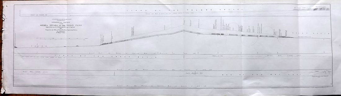
Sold2023Williamson, Lieut. R. S. 1856 LG Chart. California - Sierra Nevada & Tejon Pass"Goelogical Section of the Sierra Nevada at the Tejon Pass" by R. S. Williamson. Lithograph Map Published 1853-61, Washington for "Reports of explorations and surveys, to ascertain the most practicablSee Sold Price
Sold2023Williamson, Lieut. R. S. 1856 LG Chart. California - Bernadino Pass, San Bernardino, Colorado Desert"Geological Sections of the Bernadino Pass" Lithograph Map Published 1853-61, Washington for "Reports of explorations and surveys, to ascertain the most practicable and economical route for a railroadSee Sold Price
Sold2023Williamson, Lieut. R. S. 1856 LG Chart. California - Colorado Desert"Sections of the Colorado Desert" Explored by Lieut R. S. Williamson. Lithograph Map Published 1853-61, Washington for "Reports of explorations and surveys, to ascertain the most practicable and econoSee Sold Price
Sold20221850 James Map of US West and Texas -- A New Map of Mexico, California & OregonTitle: 1850 James Map of US West and Texas -- A New Map of Mexico, California & Oregon Cartographer: J A & U P James Year / Place: 1850, Cincinnati Map Dimension (in.): 12.5 X 9.5 in. This is an excelSee Sold Price
Sold2020German map of California & Texas 1852Heading: (Texas) Author: Meyer, Joseph Title: Vereinigte Staaten von Nord-America: Californien, Texas und die Territorien New Mexico u. Utah Nach den neuesten Hülfsmitte In gezeich. von J. Grässl. 1See Sold Price
Sold2020Tallis map of Texas, California & Mexico 1851Heading: (Texas) Author: Tallis, John Title: Mexico, California and Texas Place Published: London & New York Publisher: Date Published: [1851] Description: Steel-engraved map, drSee Sold Price
Sold2017Flemming: Mexico, Mittel-America, Texas, 1858Map: Mexico, Mittel-America, Texas Publisher: Flemming Date: 1858 Size: 13 x 16.6 inches Published after California became a state in 1850 and naming Utah and New Mexico territories. Printed colors (oSee Sold Price
Sold2017Four 19th Century Maps Pertaining to the Western Unitedas follows: Geological Map of a Part of the State of California Explored in 1855 by Lieut. R. S. Williamson U.S. Top Engr (Washington: War Department, 1856); color-coded (24.5 x 19.25 in.) (Some edgeSee Sold Price
Sold2019N. Amer. map w/huge Texas, New Calif. Terr.Reserve Reduced! Interesting map of North America showing a huge Texas, large Oregon Territory and New California. Dates to at least 1850 because that’s when New Mexico became a territory. Drawn andSee Sold Price
Sold2023Signed by Ansel AdamsHeading: Author: Adams, Ansel Title: Photographs of the Southwest: Selected photographs made from 1928 to 1968 in Arizona, California, Colorado, New Mexico, Texas and Utah Place Published: Boston PubSee Sold Price
Sold2018Ansel Adams Photographs of the Southwest signedHeading: Author: Adams, Ansel Title: Photographs of the Southwest: Selected photographs made from 1928 to 1968 in Arizona, California, Colorado, New Mexico, Texas and Utah... Place Published: BostonSee Sold Price
Jun 23Schilb Antiquarian Rare Books1848 Emory Military Reconnaissance 1ed California MAP Indians Texas New MexicoUS$2(2 bids)
Jun 12Dan Morphy AuctionsBRUE'S MONUMENTAL WALL MAP OF TEXAS, UPPER CALIFORNIA & MEXICO, C. 1845US$500
Jun 23Schilb Antiquarian Rare Books1877 Geology Geography Surveys 1ed Nevada Wyoming Utah George Wheeler US West 2vUS$1
8 hrs LeftThomaston Place Auction GalleriesCOLLECTION OF TRAVEL EPHEMERA, BROCHURES, BOOKLETS, MAPS 1900-1950US$100
Jun 04Freeman's | HindmanHoward Russell Butler (1856 - 1934) - Heavy Pulling, Coast of CaliforniaUS$1,000
Jun 09Austin Auction GalleryGLENNA GOODACRE (TX, 1939-2020) BRONZE MAQUETTE, 'PHILOSOPHER'S ROCK'US$1,500(1 bid)
Jun 07Freeman's | HindmanYOUNGBLOOD, Charles L. Adventures of... During Ten Years on the Plains. 1882. FIRST EDITION.US$200
Jun 01Ripley AuctionsGene & Rebecca Tobey, Texas, New Mexico (B. 1945/48), Windwalker, 1993, bronze, 21 1/2"H x 13"W xUS$750(4 bids)
4 days LeftTime AuctionTamara De Lempicka (1898 - 1980) New York / France Artist Oil On BoardUS$225(2 bids)
7 hrs LeftMynt Auctions1998 New Mexico St. v Longhorns Football Program Mack Brown 1st Game R. WilliamsUS$10
2 days LeftEldred'sJOHN R. GRABACH (New Jersey/California, 1886-1981), "Man with Flagon"., Oil on board, 19.5" x 15.5".US$400


![Mexico, California & Texas. CA Gold rush districts. Utah & NM Territory 1856 map: Title: Mexico, California & Texas. CA Gold rush districts. Utah & NM Territory 1856 map Description: Mexico, California & Texas [inset: Guatimala or Central America] by Sidney Hall (1856). Antique atl](https://p1.liveauctioneers.com/5584/314775/168780521_1_x.jpg?height=310&quality=70&version=1704837726)


![Tallis map of Texas, California & Mexico 1851: Heading: (Texas) Author: Tallis, John Title: Mexico, California and Texas Place Published: London & New York Publisher: Date Published: [1851] Description: Steel-engraved map, dr](https://p1.liveauctioneers.com/642/174090/87617796_1_x.jpg?height=310&quality=70&version=1595023143)


![[BOOKS] ADAM CLARK VROMAN. LOT OF 3 VOLUMES (1 of 4)](https://p1.liveauctioneers.com/8124/329546/177689829_1_x.jpg?height=282&quality=70&version=1715469494)


![J.R. Willis [New Mexico] Color Tinted Photo (1 of 5)](https://p1.liveauctioneers.com/5755/328994/177336926_1_x.jpg?height=282&quality=70&version=1715118882)


![[MEXICO / SOUTH AMERICA] LOT OF 8 PRINTS TOGETHER (1 of 6)](https://p1.liveauctioneers.com/8124/329546/177689719_1_x.jpg?height=282&quality=70&version=1715469494)


