Sold2021Large Map of Oklahoma & Indian TerritoriesMap of Oklahoma & Indian Territories With map of New Mexico on verso Cartographer: George Franklin Cram Dated: Circa 1900 Type: Color LithographSee Sold Price
Sold2023Oklahoma / Indian Territory Indian Trader Billheads & Letterheads [158048]Lot of 3 different. 1) Billhead for CA Cleveland & Co., Indian Traders and Dealers in General Merchandise, Hides, Furs, and Indian Trinkets. Anadarko, O.T., 1897. 2) Pictorial letterhead for SJ Scott,See Sold Price
Sold2017COLLECTION OF MAPSPORTUGAL, OKLAHOMA INDIAN TERRITORY, AMSTERDAM, BERLIN, CUBA. SMALLEST IS 9 1/2" BY 11 1/2". LARGEST IS 13" BY 18 1/2"See Sold Price
Sold20181895 Rand McNally Map of Texas and Indian TerritoryTitle/Content of Map: 1895 Rand McNally Map of Texas and Indian Territory/Oklahoma -- Texas; Oklahoma and Indian Territory Date Printed: 1895 Chicago Cartographer: Rand McNally Size: 9.2 x 12.5 in. ThSee Sold Price
Sold20201898 Rand McNally Map of Texas and IndianTitle/Content of Map: 1898 Rand McNally Map of Texas and Indian Territory/Oklahoma -- Texas; Oklahoma and Indian Territory Date: 1898, Chicago Cartographer: Rand McNally Size: 9.2 x 12.5 in. This mapSee Sold Price
Sold2017Rand McNally: Antique Map of Texas & Indian TerritoryMap: 1895 Rand McNally Map of Texas and Indian Territory/Oklahoma -- Texas; Oklahoma and Indian Territory Cartographer: Rand McNally Year / Place: 1895 Chicago Map Dimensions: 9.2 x 12.5 in. ConditionSee Sold Price
Sold20201895 Rand McNally Map of Texas and IndianTitle: 1895 Rand McNally Map of Texas and Indian Territory/Oklahoma -- Texas; Oklahoma and Indian Territory Cartographer: Rand McNally Year/Place: 1895, Chicago Size: 9.2 x 12.5 in. Description: ThisSee Sold Price
Sold2017Rand McNally: Antique Map of Texas & Indian TerritoryTitle/Content of Map: 1895 Rand McNally Map of Texas and Indian Territory/Oklahoma -- Texas; Oklahoma and Indian Territory Date Printed: 1895 Chicago Cartographer: Rand McNally Size: 9.2 x 12.5 in. CoSee Sold Price
Sold20181896 Rand McNally Map of Texas and Indian TerritoryTitle/Content of Map: 1896 Rand McNally Map of Texas and Indian Territory/Oklahoma -- Texas [verso] Oklahoma and Indian Territory Date Printed: 1896 Chicago Cartographer: Rand McNally Size: 9.2 x 12.5See Sold Price
Sold2019AN ANTIQUE MAP, "Map of Oklahoma and Indian Territory,"AN ANTIQUE MAP, "Map of Oklahoma and Indian Territory," 1890-1892, color engraving on paper, copyrighted by Mast, Crowell & Kirkpatrick, with view of Beaver. 10.375" x 13" Note: Showing populations oSee Sold Price
Sold2023Antique Lenny & Sawyer Enoch Delaware Native American Boudoir Cabinet PhotoThis is an Antique Lenny & Sawyer Purcell Oklahoma Indian Territories Enoch Delaware Native American Boudoir Cabinet Photo…Overall including the backing card it measures 8 1/2 x 5 1/4 inches â�See Sold Price
2018W. Harper Miniature Whiskey JugW. Harper Miniature Whiskey Jug Late 19th Century 3 1/2" H Miniature jug, "Compliments I W Harper Nelson Co, KY" American Whiskey Bourbon Company. American Please note that this lot has a confidentialSee Sold Price
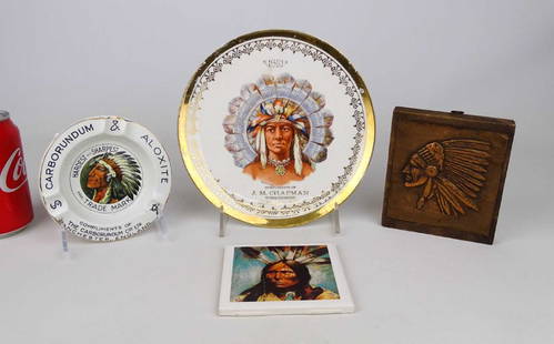
Sold2018American Indian LotLot (4) pieces including porcelain plate dated 1910, marked "COMPLIMENTS OF J. M. CHAPMAN TOBACCONIST, OLEAN N.Y." (8 1/2" D.), coaster, embossed copper, porcelain ashtray "COMPLIMENTS OF THE CARVORUNSee Sold Price
Sold2017Cram: Map of Indian Territory, 1889An original map published in 1889 depicting the Indian Reservations in what is now the state of Oklahoma. 9.5 x 12" Please note that this lot has a reserve. When you leave a bid in advance of the auctSee Sold Price
Sold2022Indian Territory, Missouri, Kansas & Oklahoma Railroad Ephemera [151542]Lot of 80. Too many companies and locations to mention all. Many tickets: Broken Arrow IT, Welch IT, Muskogee IT, Dacoma OK, Winona MO, Miami OK, Kansas City, Waconer IT, etc. One 1891 employee time pSee Sold Price
Sold2023[NATIVE AMERICANS]. A group of 3 boudoir photographs of Cheyenne and Arapaho Indians at Fort Reno,[NATIVE AMERICANS]. A group of 3 boudoir photographs of Cheyenne and Arapaho Indians at Fort Reno, Oklahoma Territory, comprising: 7 3/4 x 4 1/2 in. boudoir photographs on cardstock mounts (toning, soSee Sold Price
Sold2023[NATIVE AMERICANS]. A group of 2 cabinet photographs of Cheyenne Indians at Fort Reno, Oklahoma[NATIVE AMERICANS]. A group of 2 cabinet photographs of Cheyenne Indians at Fort Reno, Oklahoma Territory, comprising: 6 3/4 x 4 1/4 in. cabinet photographs on cardstock mounts (toning and spotting/soSee Sold Price
Sold2022Lot of American Indian Head PenniesComprising: 1859, (2) 1863, (2) 1864, 1873, 1874, 1883, 1888, 1896, 1898, (2) 1899, (2) 1902, 1903, 1905, and 1896.See Sold Price
Sold2023Lot of Native American Indian ArtComprising a illegibly signed black on black pueblo pot, a faux carved skull fetish, an illegibly signed kachina doll, and a lidded jar, also illegibly signed. pueblo pot 2 3/4" tall.See Sold Price
Sold2016Mixed lot of American Coinage1907 Indian Head Penny, 1935 Buffalo Nickel, 2-1936 Buffalo Nickels, 1937 Wheat, 1957D Wheat Uncirculated, 1908 V Nickel, 1955S Uncirculated Dime. And a 1942 Australian 3 pence.See Sold Price
Sold2022Scarce map of Indian Terr., Kansas, Missouri, IllinoisScarce map of a cross section of American states and hand-colored by county at the time of publishing. Shows Oklahoma Territory when it was inhabited mostly by Native American tribes. Shows forts, raiSee Sold Price
Sold2022Vintage map of North America, Johnson/Ward, 1865Dynamic map of the North American continent with Dakota still a complete territory (Wyoming still part of Dakota). Nevada, Utah, Arizona still with unsettled borders and Oklahoma remains Indian TerritSee Sold Price
Sold2023Clementine Hunter (American/Louisiana)Clementine Hunter (American/Louisiana, 1886-1988), "Baptism", oil on board, monogrammed lower right, 16 in. x 24 in., framed, overall 18 1/4 in. x 26 1/8 in. x 1 1/2 in. Note: This lot has been authenSee Sold Price
Sold2020JULIAN ONDERDONK, (American, 1882-1922), Texas Morning,JULIAN ONDERDONK(American 1882-1922)Texas Morningoil on boardsigned Julian Onderdonk lower left7 x 4 1/2 in. frame: 8 x 6 1/2 in.Provenance: Shannon's Fine Art Auctioneers Lot 37 OctoSee Sold Price
2 days LeftHolabird Western Americana CollectionsIndian Territory Map by Donaldson, 1883 [181628]US$100
Jun 12Dan Morphy AuctionsINDIAN TERRITORY - DEPARTMENT OF THE INTERIOR GENERAL LAND OFFICE, C.1883US$100(1 bid)
4 days LeftHolabird Western Americana CollectionsTwo Different Con. Virginia Mining Company Annual Reports 1880-1913 [164475]US$450
2 days LeftHolabird Western Americana CollectionsBritish Plantation Map of the Americas [179303]US$200
2 days LeftHolabird Western Americana CollectionsEarly French Map of East Coast & Canada [179301]US$200
Jun 15Bazaar of PersiaLot of US 2 cent 1879-87 american stamps - soft paper and 1887-88 new colorsUS$30
3 days LeftSimpson Galleries, LLC.SIGNED BY PRESIDENT WILLIAM MCKINLEY, A DAWES ACT OF 1887 UNITED STATES OF AMERICA LAND GRANT TOUS$150(1 bid)
4 days LeftHolabird Western Americana CollectionsComstock Bonanza Kings Checks: Eagle Salt Works, John Mackay, & Occidental Mill, Fair, 1879 [182804US$75
2 days LeftHolabird Western Americana CollectionsColorado Midland RY Co. passes., 1907-08 [172141]US$50
2 days LeftHolabird Western Americana CollectionsGulf, Colorado & Santa Fe RY. passes, 1907/09 [172081]US$50
1 day LeftAustin Auction Gallery(2) STUDIO ART GLASS PAPERWEIGHTS, HARRY BOYER & LUNDBERGUS$100(2 bids)
4 days LeftThriftiques of IowaNative American Indian Peace Medal John Quincy Adams. Dated 1825US$42(4 bids)


![Oklahoma / Indian Territory Indian Trader Billheads & Letterheads [158048]: Lot of 3 different. 1) Billhead for CA Cleveland & Co., Indian Traders and Dealers in General Merchandise, Hides, Furs, and Indian Trinkets. Anadarko, O.T., 1897. 2) Pictorial letterhead for SJ Scott,](https://p1.liveauctioneers.com/2699/274457/144083486_1_x.jpg?height=310&quality=70&version=1672962673)


![1896 Rand McNally Map of Texas and Indian Territory: Title/Content of Map: 1896 Rand McNally Map of Texas and Indian Territory/Oklahoma -- Texas [verso] Oklahoma and Indian Territory Date Printed: 1896 Chicago Cartographer: Rand McNally Size: 9.2 x 12.5](https://p1.liveauctioneers.com/5584/120548/61369196_1_x.jpg?height=310&quality=70&version=1524013707)


![Indian Territory, Missouri, Kansas & Oklahoma Railroad Ephemera [151542]: Lot of 80. Too many companies and locations to mention all. Many tickets: Broken Arrow IT, Welch IT, Muskogee IT, Dacoma OK, Winona MO, Miami OK, Kansas City, Waconer IT, etc. One 1891 employee time p](https://p1.liveauctioneers.com/2699/254720/132471799_1_x.jpg?height=310&quality=70&version=1657566291)
![[NATIVE AMERICANS]. A group of 3 boudoir photographs of Cheyenne and Arapaho Indians at Fort Reno,: [NATIVE AMERICANS]. A group of 3 boudoir photographs of Cheyenne and Arapaho Indians at Fort Reno, Oklahoma Territory, comprising: 7 3/4 x 4 1/2 in. boudoir photographs on cardstock mounts (toning, so](https://p1.liveauctioneers.com/197/290824/154051765_1_x.jpg?height=310&quality=70&version=1685134375)
![[NATIVE AMERICANS]. A group of 2 cabinet photographs of Cheyenne Indians at Fort Reno, Oklahoma: [NATIVE AMERICANS]. A group of 2 cabinet photographs of Cheyenne Indians at Fort Reno, Oklahoma Territory, comprising: 6 3/4 x 4 1/4 in. cabinet photographs on cardstock mounts (toning and spotting/so](https://p1.liveauctioneers.com/197/290824/154051766_1_x.jpg?height=310&quality=70&version=1685134375)


![Indian Territory Map by Donaldson, 1883 [181628] (1 of 1)](https://p1.liveauctioneers.com/2699/331495/178785757_1_x.jpg?height=282&quality=70&version=1717094933)

![Two Different Con. Virginia Mining Company Annual Reports 1880-1913 [164475] (1 of 4)](https://p1.liveauctioneers.com/2699/331499/178846257_1_x.jpg?height=282&quality=70&version=1717095214)


![North America Map circa 1800s [179302] (1 of 1)](https://p1.liveauctioneers.com/2699/331495/178785793_1_x.jpg?height=282&quality=70&version=1717094933)
![British Plantation Map of the Americas [179303] (1 of 1)](https://p1.liveauctioneers.com/2699/331495/178785748_1_x.jpg?height=282&quality=70&version=1717094933)
![Maps of Asia & India, c1800's (2) [180164] (1 of 2)](https://p1.liveauctioneers.com/2699/331495/178785787_1_x.jpg?height=282&quality=70&version=1717094933)
![Jacob Monk 1853 Map of North America [173506] (1 of 11)](https://p1.liveauctioneers.com/2699/331495/178785775_1_x.jpg?height=282&quality=70&version=1717094933)
![Early French Map of East Coast & Canada [179301] (1 of 1)](https://p1.liveauctioneers.com/2699/331495/178785745_1_x.jpg?height=282&quality=70&version=1717094933)


![Colorado Midland RY Co. passes., 1907-08 [172141] (1 of 2)](https://p1.liveauctioneers.com/2699/331495/178785913_1_x.jpg?height=282&quality=70&version=1717094933)
![Gulf, Colorado & Santa Fe RY. passes, 1907/09 [172081] (1 of 2)](https://p1.liveauctioneers.com/2699/331495/178785966_1_x.jpg?height=282&quality=70&version=1717094933)


