Sold2022A late 18th century map sampler depicting southern Scotland, England and WalesA late 18th century map sampler depicting southern Scotland, England and Wales Also including the east coast of Ireland and northern France, worked on a linen group and signed and inscribed 'Wrought iSee Sold Price
Sold2022[MANUSCRIPT MAP-CARIBBEAN] Carte de L'Isle Dominique. France, likely 18th century. A manuscript map[MANUSCRIPT MAP-CARIBBEAN] Carte de L'Isle Dominique. France, likely 18th century. A manuscript map in colors on laid paper, with a decorative title cartouche and inset map of the Caribbean islands, 1See Sold Price
Sold201718th C. French Map w/ Oiled Paper, ex-Sotheby'sEurope, France, map from 1709 CE, oiled paper overlays from 1756 to 1763 CE, owned by Louis-Alexandre Berthier (1753 to 1815 CE), Marshal, Vice-Constable of France, and Chief of Staff (Major general)See Sold Price
Sold20231741 antique MAP OF FRANCE REGNI GALLIEAE SEU FRANCIAE et Navarrae Tabula 18th CREGNI GALLIEAE SEU FRANCIAE et Navarrae Tabula Geographicea by Homann, Johann Baptist, 1663-1724 Nuremberg, 1741 size 20.5 by 24.5" Wear , damaged lower margin, as visible on the photos Reserve: $105.See Sold Price
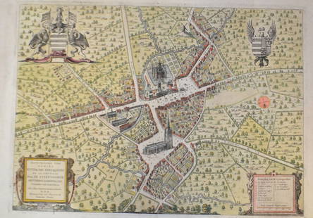
Sold201518th C French Map Of SteenvoordePLOUICH, Vedastus du -" Illvstrissimo viro domino" .The city of Steenvoorde is a small town located north of France. The city of Steenvoorde is located in the department of Nord of the french region.See Sold Price
Sold20201774 ATLAS Bruyset 25 Color Maps AMERICA Scandinavia1774 ATLAS Bruyset 25 Color Maps AMERICA Scandinavia France Geography RARE ‘Atlas des enfans’ or ‘Children’s Atlas’ is a rare, late 18th-century atlas designed by Jean Marie Bruyset to makeSee Sold Price
Sold20201774 ATLAS Bruyset 23 Color Maps AMERICA Scandinavia1774 ATLAS Bruyset 23 Color Maps AMERICA Scandinavia France Geography RARE ‘Atlas des enfans’ or ‘Children’s Atlas’ is a rare, late 18th-century atlas designed by Jean Marie Bruyset to makeSee Sold Price
Sold20201774 ATLAS Bruyset 23 Color Maps AMERICA Scandinavia1774 ATLAS Bruyset 23 Color Maps AMERICA Scandinavia France Geography RARE ‘Atlas des enfans’ or ‘Children’s Atlas’ is a rare, late 18th-century atlas designed by Jean Marie Bruyset to makeSee Sold Price
Sold20201765 Paris FRANCE City View Maps Architecture Art1765 Paris FRANCE City View Maps Architecture Art Piganiol ILLUSTRATED A rare geographical study of France by Piganiol! Piganiol de la Force was an 18th-century French author known almost exclusivelySee Sold Price
Sold20201765 Paris FRANCE City View Maps Architecture Art1765 Paris FRANCE City View Maps Architecture Art Piganiol ILLUSTRATED A rare geographical study of France by Piganiol! Piganiol de la Force was an 18th-century French author known almost exclusivelySee Sold Price
Sold2023Carel Allard, Map the Sevennes Region in South Central FranceCarel Allard, Map the Sevennes Region in South Central FranceAmsterdam, early 18th century, copperplate engraving with outline color; focusing of the Diocese of Monpellier; matted and framed under glaSee Sold Price
2020French Antique Louis XIII Style Fireplace 18th C FranceA French antique Louis XIII style fireplace hand carved in limestone from France, 18th century. Origins from the early 1700s. Beautiful original patina and sculpture on the front of the mantel. It hasSee Sold Price
Sold202418th C. Map of Arabia by Emanuel Bowman18th Century Map of Arabia, Turkey and Asia by Emanuel Bowman. Hand-colored engraving dated 1769 and framed behind plexiglass. Measurements: Map - 14"H x 17"W. Frame 21"H x 24"W. Condition report: GooSee Sold Price
Sold2020500 sqf French Grey Barre stone flooring 18thC France.500 square feet lot of original French Grey Barre stone flooring early 18th century. Ready for installation. Authentic from the South of France, city of "Nimes" area. Available right now as well fromSee Sold Price
Sold2020250 sqf French antique square terra cotta 18thC FranceA lot of 250 square feet of French antique terra cotta, original and authentic 18th century from France (circa 1700s). Hand-selected, cleaned and ready for installation. Same thickness at 1 inch. AvaiSee Sold Price
Sold2018ANTONIO ZATTA (ITALIAN, 18TH CENTURY) MAP / ATLAS OFANTONIO ZATTA (ITALIAN, 18TH CENTURY) MAP / ATLAS OF NORTH AMERICA, SET OF 12, hand-colored, on laid paper, comprising title page lettered in part "LE / COLONIE UNITE / DELL' / AMERICA SETTENTR'LE." aSee Sold Price
Sold2024Exceptional 18th Century Map of The Carolinas, Maryland and VirginiaBy Johann Baptist Homann, Germany, late 17th/early 18th century. Hand colored map of the region which is excellent and quite rare. The map giving excellent details of the region and having exquisite eSee Sold Price
Sold201718th Century Map of the Carolinas by Thomas Conder1788, London. The map features the Carolinas and part of Georgia including Savannah and Augusta. The piece is in good overall condition with some scattered wrinkles and fold lines consistent with ageSee Sold Price
Sold2022TWO 16TH TO 18TH CENTURY MAPSA lot of two sixteenth to eighteenth century maps. To include: "A Map of the Parish of St. Giles's" Sheet: 14" x 16.75" "Londinum Feracissimi", engravings on laid paper Sheet: 14.75" x 21"See Sold Price
Sold202218th century map of the arctic pole by Bleu18th century map of the arctic pole by Bleu 20 inches x 23.5 inchesSee Sold Price
Sold2018LAURIE & WHITTLE BRITISH 18TH CENTURY MAP OF NORTHLAURIE & WHITTLE BRITISH 18TH CENTURY MAP OF NORTH AMERICA, hand-colored, title in cartouche to upper right corner "A NEW AND CORRECT MAP / OF THE / BRITISH COLONIES IN NORTH AMERICA / Comprehending /See Sold Price
Sold2023Jean Janvier - 18th Century Map of the AmericasJean Janvier (fl. 1746-1776), L'Amerique Septentrionale divisee en ses principaux Etats…, Paris, 1762, engraving on laid paper with hand colored highlights, sight 14-1/8 x 19-3/4 in.; wood framSee Sold Price
Sold202218th century map of China, Sinarum Regio18th century map of China, Sinarum Regio 20 inches x 23 inchesSee Sold Price
Sold202418th century map "Americae Septentrion" by Homann. Rarer early edition. Framed. Holes around outer18th century map "Americae Septentrion" by Homann. Rarer early edition. Framed. Holes around outer edge and staining. Inside frame sight: 19.25 x 23.5in. Overall: 22.75 x 27in.See Sold Price
22 hrs LeftJasper52L'Afrique Françoise ou du Senegal'. French West Africa. DE L’ISLE 1727 mapUS$100
Jun 15Riverfront Auctions'1785 Bocage Map of the City of Athens in Ancient Greece' Par M. Barbié du BocageUS$5(1 bid)
3 days LeftHolabird Western Americana CollectionsFrench Map of America Southwest & Mexico [179298]US$170
Jun 14DuMouchellesRigobert Bonne (French, 1727-1794) Hand Colored Engraving Ca. 18th Century, Les Etats Unis DeUS$50(1 bid)
Jun 23East Coast Fine Arts LLC18th C French Illegibly Signed Dugazon Opera Figaro Collection Stamp E CalandoUS$1,200
Jun 30Global Auctions CompanyCharles Dupuis French 18th century, Pair Hand Colored Engravings, ArchitecturalUS$400
Jun 19Flanders AuctionsAn antique map of Ingelumunster and two 'Heerlijkheden van Picquenij', 18th C. (W:42 x H:33 cm)€160


![[MANUSCRIPT MAP-CARIBBEAN] Carte de L'Isle Dominique. France, likely 18th century. A manuscript map: [MANUSCRIPT MAP-CARIBBEAN] Carte de L'Isle Dominique. France, likely 18th century. A manuscript map in colors on laid paper, with a decorative title cartouche and inset map of the Caribbean islands, 1](https://p1.liveauctioneers.com/292/250642/130213642_1_x.jpg?height=310&quality=70&version=1654271664)


![The Sea Coast of France from Ushent to Olone [Olonne]. MOUNT & PAGE 1758 map (1 of 1)](https://p1.liveauctioneers.com/5584/332390/179263262_1_x.jpg?height=282&quality=70&version=1717528223)


![French Map of America Southwest & Mexico [179298] (1 of 1)](https://p1.liveauctioneers.com/2699/331495/178785763_1_x.jpg?height=282&quality=70&version=1717094933)