Sold2023Atoll of Ebon. Pacific Ocean. Marshall Islands. Sketch map 1886 oldTITLE/CONTENT OF MAP: 'Atoll of Ebon' DATE PRINTED: 1886 IMAGE SIZE: Approx 11.5 x 11.5cm, 4.5 x 4.5 inches (Small) TYPE: Antique engraved sketch map CONDITION: Good; suitable for framing. Please checSee Sold Price
Sold2023Atoll of Menchikoff. Marshall Islands. Kwajalein Atoll. Sketch map 1886TITLE/CONTENT OF MAP: 'Atoll of Menchikoff' DATE PRINTED: 1886 IMAGE SIZE: Approx 9.0 x 11.0cm, 3.5 x 4.25 inches (Small) TYPE: Antique engraved sketch map CONDITION: Good; suitable for framing. PleasSee Sold Price
Sold2017Wonderful old Marquesas bowlTribal art (Marquesas Islands, French Polynesia, 20th c.) Beautiful and well used carved wood bowl from the Marquesas Islands decorated with stylized tiki figures. Exotic hardwood, possible ironwood oSee Sold Price
Sold2021Fine Tongan Island Club, French Polynesia, 18th/19th C.A Fine Tongan Island Club, French Polynesia, 18th/19th century. The cylindrical shaft and ovate blade with overall intricate geometric chip carving. Sometimes called "hoe" after the Tahitian word forSee Sold Price
Sold201820th C. Marquesas Islands Wooden U'u ClubOceania, French Polynesia, Marquesas Islands, Enata peoples, ca. 20th century CE. A fabulous u'u club, hand-carved from iron wood and meticulously polished to a smooth textured feel. The club's classiSee Sold Price
Sold201819th C. Marquesas Islands Wooden Ancestral FigureFrench Polynesia, Marquesas Islands, ca. 19th century CE. A tall, hand-carved wooden figure representative of a deceased ancestor. The statue has a rotund body which sports a pair of nubbin-shaped legSee Sold Price
Sold202119th C. Marquesas Islands Stone Poi PounderFrench Polynesia, Marquesas Islands, Enata peoples, ca. late 18th to early 19th century CE. An intriguing and elegant poi pounder, hand-carved from light gray basalt stone, used for repeatedly poundinSee Sold Price
Sold2016Marquesas Islands Carved Container - 19th CenturyMarquesas Islands tobacco or water container made from a coconut shell and decorated with traditional tribal carvings. French Polynesia. 19th Century. Hollowed coconut shell with woven fiber handle. OSee Sold Price
Sold2023AFTER NICOLAS SANSON (FRENCH, 1600-1667) MAP OF CALIFORNIA AS AN ISLANDAFTER NICOLAS SANSON (FRENCH, 1600-1667) MAP OF CALIFORNIA AS AN ISLAND, hand-colored engraving on laid paper, titled "AUDIENCE DE / GUADALAJARA / NOUVEAU MEXIQUE / CALIFORNIE, &c. / Par N. SSee Sold Price
Sold2018JANSON, HONDIAS C. 1650 MAP OF NORTH AMERICAOriginal hand colored engraving with center fold. French text verso. Titled "America Septentrionalis." Famous map with California as an island. Dimensions: (Frame) H 26" x W 29", (Sight) H 19.25" x WSee Sold Price
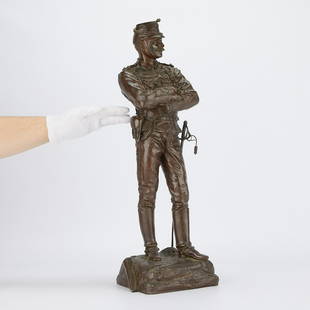
Sold2023Charles Anfrie Bronze Soldier Statue 1886Charles Anfrie (French, 1833-1905). Bronze statue titled "Quana Vous Voudrez (Whenever You Want)" depicting a Chasseurs d'Afrique officer standing with his arms crossed with a map reading &qSee Sold Price
Sold20201711 MAPS Atlas Geography Africa Asia America1711 MAPS Atlas Geography Africa Asia America California Island France Buffier Claude Buffier was a 17th-century French historian who published works on metaphysics, grammar, and, most notably, univerSee Sold Price
Sold202119th C. Polynesian Samoan Fiber Tapa Eventail**Originally Listed At $7500** Polynesia, Samoa Islands, ca. 19th century CE. A remarkably well-preserved fan, also sometimes known as an eventail, the French word for fan (due to French colonial ventSee Sold Price
Sold2022Marcel Andre Bouraine (French, 1886 - 1948) Penthesilia SculptureMarcel Andre Bouraine (French, 1886 - 1948) Penthesilia Sculpture bronze signed and marked 'Susse Freres Paris / Cire Perdue' on base H 19 x width 34 1/2 x depth 10 inches. Property from the Estate ofSee Sold Price
Sold201718th C. French Map w/ Oiled Paper, ex-Sotheby'sEurope, France, map from 1709 CE, oiled paper overlays from 1756 to 1763 CE, owned by Louis-Alexandre Berthier (1753 to 1815 CE), Marshal, Vice-Constable of France, and Chief of Staff (Major general)See Sold Price
Sold2021Antique French Map of MississippiAntique French Map of Mississippi , "Carte Geographique, Statistique et Historique du Mississipi", Paris, Buchon, 1825, sight 21 in. x 27 1/2 in., framed Provenance: Estate of Julia Evans ReedSee Sold Price
Sold2023Jacques Majorelle(French, 1886-1962) Crepuscule, Anemiter, vallee de l'Ounila, Grand Atlas, signature incised in wet paint lower left "J. Majorelle", inscribed verso, old labels verso with title and numbered "24", oilSee Sold Price
Sold2021Roger Bissiere (French, 1886-1964) Carre LuneRoger Bissiere (French, 1886-1964) Carre Lune (Composition 206), 1954 oil on canvas signed Bissiere and dated (Iower right) 31 1/4 x 29 1/2 inches. Sold to Benefit the Acquisition Fund of the IndianapSee Sold Price
Sold2018Amedee Ozenfant 1947 painting Ships at PortOzenfant, Amedee (French, 1886-1966), Ships at Port, 1947, oil on canvas, 39.5 x 32 inches, signed lower right, KG47 inscribed on canvas reverse, Provenance: M. Knoedler Gallery, New YorkSee Sold Price
Sold2024Guillaume Desgranges (French, 1886-1967), after Robert Lefèvre (French, 1755-1830)Guillaume Desgranges (French, 1886-1967), after Robert Lefèvre (French, 1755-1830) Portrait of Charles-France Lebrun, duc de Plaisance oil on canvas signed (lower right) 87 x 54 inches (sSee Sold Price
Sold2021Dimitri Chiparus (Romanian/French, 1886-1947)Dimitri Chiparus (Romanian/French, 1886-1947) Sculpture of a Woman gilt bronze, onyx signed "Chiparus" 14 1/2 x 6 x 5 inchesSee Sold Price
Sold2022Painting, Robert Antoine PinchonRobert Antoine Pinchon (French, 1886-1943), "La Cathedrale d'Amiens," oil on canvas, signed lower right, with artist label affixed verso, canvas: 36"h x 46"w, overall (with frame): 42"h x 52"w. ProvenSee Sold Price
Sold2022Apostolos Geralis (Greek / French, 1886-1983) Oil on CanvasApostolos Geralis (Greek / French, 1886-1983) Oil on Canvas Undated, signed upper right, depicting female figure sitting in front of a open window, in a gold tone wood frame Property from: a Sycamore,See Sold Price
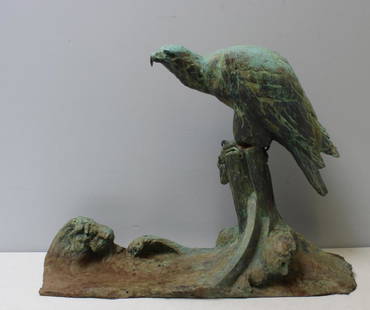
Sold2018FIOT, M. Large Signed Patinated Bronze of an EagleA magnificent and large sculpture. Signed on the base. Maximilien Louis Fiot (French 1886 - 1953). From a Scarsdale, NY estate. - Dimensions: 31" x 23" x 9.5".See Sold Price
59 mins LeftJasper52Océanique Partie… des Iles Basses 48 SE Tuamotus Polynesia VANDERMAELEN 1827 mapUS$55
59 mins LeftJasper52Océanique Partie… des Iles Basses 48 SE Tuamotus Polynesia VANDERMAELEN 1827 mapUS$55
59 mins LeftJasper52Océanique Iles de la Société #42 Tahiti Rangiroa Polynesia VANDERMAELEN 1827 mapUS$85
59 mins LeftJasper52Océanique Iles de la Société #42 Tahiti Rangiroa Polynesia VANDERMAELEN 1827 mapUS$85
59 mins LeftJasper52South Pacific Islands. New Hebrides Loyalty Fiji Friendly Polynesia 1860 mapUS$45
59 mins LeftJasper52South Pacific Islands. New Hebrides Loyalty Fiji Friendly Polynesia 1859 mapUS$45
59 mins LeftJasper52Gambier Archipelago. French Polynesia 1885 old antique vintage map plan chartUS$10
59 mins LeftJasper52Océanique Partie… des Iles Basses 43 NE Tuamotus Polynesia VANDERMAELEN 1827 mapUS$65
59 mins LeftJasper52Pacific Ocean & islands. Hawaii Polynesia Tahiti. TIMES 1957 old vintage mapUS$30
59 mins LeftJasper52Océanique Partie… des Iles Basses 43 NE Tuamotus Polynesia VANDERMAELEN 1827 mapUS$65
59 mins LeftJasper52Kingsmill Group. Gilbert Islands. Apia Tarawa Maiana Maraki. Sketch map 1886US$10
59 mins LeftJasper52Carte des Isles des Amis. Friendly or Tonga Islands. Tongatapu. BONNE 1788 mapUS$30
59 mins LeftJasper52Carte des Isles des Amis. Friendly or Tonga Islands. Tongatapu. BONNE 1790 mapUS$30
59 mins LeftJasper52South Pacific Ocean. French Polynesia Cook Islands. US Navy sea chart 1895 mapUS$140
59 mins LeftJasper52PACIFIC ISLANDS Polynesia Hawaii Samoa Fiji Tahiti Galapagos. LETTS 1884 mapUS$40
59 mins LeftJasper52PACIFIC ISLANDS Polynesia Hawaii Samoa Fiji Tahiti Galapagos. LETTS 1883 mapUS$40
59 mins LeftJasper52Océanique. Partie… des Iles Basses #49 Gambiers Polynesia. VANDERMAELEN 1827 mapUS$60
59 mins LeftJasper52Océanique. Partie… des Iles Basses #49 Gambiers Polynesia. VANDERMAELEN 1827 mapUS$60
59 mins LeftJasper52South Pacific Ocean. Polynesia "Dangerous Archipelago" Galapagos LIZARS 1842 mapUS$40
59 mins LeftJasper52PACIFIC ISLANDS. Hawaii Samoa Fiji New Caledonia Society Islands 1952 old mapUS$10
59 mins LeftJasper52Pacific Islands. Melanesia Polynesia Micronesia. Hawaii. STANFORD 1896 old mapUS$85
59 mins LeftJasper52Pacific Islands. Melanesia Polynesia Micronesia. Hawaii. STANFORD 1894 old mapUS$85
59 mins LeftJasper52Océanique. Archipel de Mendana #34. Marquesas Polynesia. VANDERMAELEN 1827 mapUS$60