Sold2024COLONIAL ASIA. East Indies &c. Inset Russian-Japanese War 1904/05 1914 old mapCAPTION PRINTED BELOW PICTURE: 'Asia in 1914' DATE PRINTED: 1914 IMAGE SIZE: Approx 19.5 x 24.0cm, 7.5 x 9.5 inches (Medium); Please note that this is a folding map. TYPE: Antique colour map CONDITIONSee Sold Price
Sold2024ASIA. East Indies & Indo-China. Industries & Communications 1907 old mapCAPTION PRINTED BELOW PICTURE: 'The East Indies and Indo-China: Industries and Communications' DATE PRINTED: 1907 IMAGE SIZE: Approx 40.5 x 52.5cm, 15.75 x 20.5 inches (Large); Please note that this iSee Sold Price
Sold2024ASIA political. British India Siam Turkish Empire East Indies 1907 old mapTITLE/CONTENT OF MAP: 'Asia' DATE PRINTED: 1907 IMAGE SIZE: Approx 23.5 x 31.0cm, 9.25 x 12.25 inches (Large); Please note that this is a folding map. TYPE: Vintage colour map CONDITION: Good; suitablSee Sold Price
Sold2024WORLD WAR 2 Japanese occupied Philippines Malaya Indochina Thailand 1942 mapTITLE/CONTENT OF MAP: 'Malaya, East Indies, Thailand and Indo-China' DATE PRINTED: 1942 IMAGE SIZE: Approx 22.5 x 27.5cm, 8.75 x 10.75 inches (Large) TYPE: Vintage colour map CONDITION: Good; suitableSee Sold Price
Sold2015De Bry (Theodore) - Descriptio Hydrographicathe 2-sheet map of Africa and Asia, from the east coast of Brazil to Japan, charting the first Dutch voyage to the East Indies by Houtman, large titlecartouche upper centre of right sheet, ships, compSee Sold Price
Sold2024NORTH & CENTRAL ASIA. Siberia Japan Korea Khiva Bokhara Turkistan 1912 old mapTITLE/CONTENT OF MAP: 'Northern Asia; Central Asia' DATE PRINTED: 1912 IMAGE SIZE: Approx 33.0 x 44.0cm, 13 x 17.25 inches (Large); Please note that this is a folding map. TYPE: Antique colour atlas mSee Sold Price
Sold2024NORTH & CENTRAL ASIA. Siberia Japan Korea Khiva Bukhara Turkistan 1901 old mapTITLE/CONTENT OF MAP: 'Northern Asia; Central Asia' DATE PRINTED: 1901 IMAGE SIZE: Approx 43.0 x 33.0cm, 17 x 13 inches (Large); Please note that this is a folding map. TYPE: Antique colour map CONDITSee Sold Price
Sold2018C.B.G EXCEEDINGLY RARE Naval Combat 1905 BattleOf Tsushima in the Russian/Japanese War. 22 pieces. Excellent condition (a few of the pieces are loose from the diorama base - can be easily reaffixed). Box with colorful background is in excellent coSee Sold Price
Sold2024CENTRAL ASIA. Bokhara Russian Turkestan Tomsk Great Horde Turgan. LETTS 1883 mapTITLE/CONTENT OF MAP: 'Russia in Asia, Turkestan, &c; Inset maps of Kara Sea; Continuation of Ieniseisk to the North Point of Asia No 1' DATE PRINTED: 1883 IMAGE SIZE: Approx 43.5 x 36.0cm, 17.25 x 14See Sold Price
Sold2024ASIA. Asia. General Map; Inset map of Population map 1907 old antiqueCAPTION PRINTED BELOW PICTURE: 'Asia: General Map; Inset map of Population map' DATE PRINTED: 1907 IMAGE SIZE: Approx 37.0 x 49.0cm, 14.5 x 19.25 inches (Large); Please note that this is a folding mapSee Sold Price
Sold2024WESTERN ASIA 970-1070 AD. under the Mohammadan Muslim Dynasties 1902 old mapTITLE/CONTENT OF MAP: 'Western Asia under the Mohammadan Dynasties C. 970 & C. 1070 A.D; Inset map of Southern Arabia' DATE PRINTED: 1902 IMAGE SIZE: Approx 25.0 x 32.0cm, 9.75 x 12.5 inches (Large) TSee Sold Price
Sold2024Middle East ethnic divisions. South west Asia. Sketch map 1885 old antiqueTITLE/CONTENT OF MAP: 'Ethnical Divisions of Hither Asia' DATE PRINTED: 1885 IMAGE SIZE: Approx 12.0 x 11.0cm, 4.75 x 4.5 inches (Small) TYPE: Antique engraved sketch map CONDITION: Good; suitable forSee Sold Price
Sold2024WESTERN ASIA IN 1600 AD. under the Turks & Persians 1902 old antique map chartTITLE/CONTENT OF MAP: 'Western Asia under the Turks & Persians A.D. 1600; Inset map of Southern Arabia' DATE PRINTED: 1902 IMAGE SIZE: Approx 25.0 x 33.0cm, 9.75 x 13 inches (Large) TYPE: Antique coloSee Sold Price
Sold2024Turkestan, or Independent Tartary by Edward Weller. Central Asia 1860 old mapCAPTION PRINTED BELOW PICTURE: Turkestan, or Independent Tartary [including Khiva, Bokhara, Kokan, Kunduz, &c., and the shores of the Caspian and of the Aral Sea,] Central Asia between the Caspian SeaSee Sold Price
Sold2024WEST ASIA.Arabia Persia Mesopotamia Russia.Rainfall population density 1920 mapCAPTION PRINTED BELOW PICTURE: 'Asia (General); Inset map of Siberia; Mongolia' DATE PRINTED: 1920 IMAGE SIZE: Approx 32.5 x 22.0cm, 12.75 x 8.75 inches (Large) TYPE: Vintage colour map; Scale 1:29,50See Sold Price
Sold201719th C. Japanese Bronze Articulated Crustacean - SignedEast Asia, Japan, Edo to Meiji period, ca. mid 19th to early 20th century CE. A bronze articulated model of a lobster, with a signature on the underside of its carapace. Meticulously constructed of nuSee Sold Price
Sold2018Signed 17th C. Japanese Tadayoshi Wakizashi & Scabbard**First Time At Auction** East Asia, Japan, early Edo Period, ca. 1615 to 1624 CE, signed by Hashimoto Shinzaemon Tadayoshi (1572-1632 CE). An incredible wakizashi with a single-edged blade, a scabbarSee Sold Price
Sold2017Rare Japanese Edo Lacquered Iron Helmet w/ EarsEast Asia, Japan, Edo Period, ca. 1830 to 1870 CE. A fascinating and incredibly unusual black lacquered Kabuto (helmet) - the hachi comprised of three pieces with an attached maebashi (visor) and shikSee Sold Price
Sold2021Large Japanese Jomon Pottery Vessel w/ TL TestEast Asia, Japan, Jomon Period, ca. 14,000 to 300 BCE, coming with a TL Report showing it was fired/ produced around 4,000 years ago. A considerable hand-built terracotta vessel of a sprouting form wiSee Sold Price
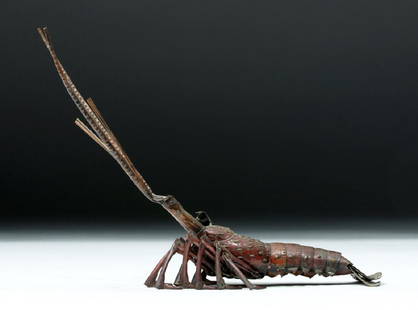
Sold2017Japanese Edo Period Articulated Crayfish - SignedEast Asia, Japan, Edo to Meiji period, ca. mid 19th to early 20th century CE. A bronze articulated model of a crayfish, with a signature on the underside of its carapace. Meticulously constructed of nSee Sold Price
Sold2024Asia 1886 old antique vintage map plan chartTITLE/CONTENT OF MAP: 'Asia' DATE PRINTED: 1886 IMAGE SIZE: Approx 21.5 x 27.0cm, 8.5 x 10.5 inches (Medium); Please note that this is a folding map. TYPE: Antique engraved colour map CONDITION: Good;See Sold Price
Sold2017Mercator (Gerard) - Atlas sive Cosmographicae,Editio Quinta, engraved pictorial title, prelims, 49 double-page maps, including Asia, Russia, Turkey, Lithuania, Asia Minor and Persia, regions of Italy Spain, Germany and Eastern Europe, and 11 singSee Sold Price
Sold2024ASIA. Hypsographical c1885 old antique vintage map plan chartTITLE/CONTENT OF MAP: 'Hypsographical Map of Asia' DATE PRINTED: c1885 IMAGE SIZE: Approx 23.5 x 30.0cm, 9.25 x 11.75 inches (Large); Please note that this is a folding map. TYPE: Antique coloured engSee Sold Price
Sold2019Asian Japanese Chinese Oriental Scroll PaintingOld East Asian Japanese or Chinese Oriental hanging scroll art painting. Features a tapestry blue & cream color matte border. On the verso is illegible Chinese writing. Artwork features a lovely orienSee Sold Price
1 day LeftTrillium Antique Prints & Rare BooksPrevost - Chart of the Gulf of Mexico (with Florida & Lousiana)US$50(1 bid)
Jun 15Bazaar of PersiaPostcard Japan special military operation Russia 1904 Russian troops killed CUS$40
4 days LeftJasper521720 Homann Map of the Caspian Sea Region -- Provinciarum Persicarum Kilaniae nempe ChirvaniaeUS$220
Jun 23Schilb Antiquarian Rare Books1816 Napoleonic War ENGLISH 1ed Campaigns Russia Invasion Labaume MAPS NapoleonUS$1(1 bid)
5 days LeftThe Bidder AuctionsAll the Russias by Henry Norman, illustr., 1st ed., 1902, in EnglishUS$25
195 Lots AwayHermann Historica GmbHA pair of Russian epaulettes for a Porutschik, circa 1910See Sold Price
Jun 08Early American History Auctionsc. 1812 War Era, Eight Political, Strong Forever, Old Massachusetts, Gubernatorial Campaign ButtonsUS$400


![Turkestan, or Independent Tartary by Edward Weller. Central Asia 1860 old map: CAPTION PRINTED BELOW PICTURE: Turkestan, or Independent Tartary [including Khiva, Bokhara, Kokan, Kunduz, &c., and the shores of the Caspian and of the Aral Sea,] Central Asia between the Caspian Sea](https://p1.liveauctioneers.com/5584/329387/177649405_1_x.jpg?height=310&quality=70&version=1715717898)