Sold2017Gentleman’s Magazine Map of the New Continent, 1758Map: A Map of the New Continent according to its greatest diametrical Length from the River la Plata to beyond the Lake of the Assiniboits Maker: Gentleman's Magazine Place & Date: London / 1758 Size:See Sold Price
Sold20231758 Magazine Barring Soccer on SundaysThe January 1758 issue of "The London Magazine", printed at London. 56 pages and one engraved map of Breslaw. Lacks the monthly title leaf but nice skyline of London on the first page. Interesting conSee Sold Price
Sold20209 Antiqe MapsIncludes: 1) A Map of a New Continent according to its Greatest Diametrical Length from the River la Plata to beyond the lake of Assiniboits. Gentleman's Magazine. London 1758. Eng. John Gibson afterSee Sold Price
Sold20241758 Folding Map Senegal RiverFolding map "A General Map of the River Sanaga or Senegal from the Falls of Govina to the Ocean..", by D'Anville and published by Labat for the July 1758 issue of London Magazine. Very Good, Some detaSee Sold Price
Sold2020London Mag 1758 Map. French Armies in Germany"A Map shewing ye Situation of the French & Allied Armies in Germany" Copper Engraved Map Published 1732-85, London for "The London Magazine" Paper Size: 8 x 5 inch (21 x 14cm) Chipping to bottom margSee Sold Price
Sold2021London Mag 1758 Map. French Armies in Germany"A Map shewing ye Situation of the French & Allied Armies in Germany" Copper Engraved Map Published 1732-85, London for "The London Magazine" Paper Size: 8 x 5 inch (21 x 14cm) Chipping to bottom margSee Sold Price
Sold20211762 Magazine Gibraltar Folding PlanThe November 1762 issue of The London Magazine, 64 pages. Folding engraving being a plan of the town and fortifications at Gibraltar. Interesting content including war news and on witches and apparitiSee Sold Price
Sold2018Carte de la Louisiane, Maryland... 1758. Map.[Southeastern US] Carte de la Louisiane, Maryland, Virginie, Caroline, Georgie, avec une Partie de la Floride. Amst: Covens & Mortier, 1758. C. Sepp Sculpsit:” at lower left. Labels the locations ofSee Sold Price
Sold20171773 Gentlemans Magazine Map Voyage South Seas Cpt CookFirst printing in original blue advertising wrapper of the Supplement issue of Gentleman's Magazine for the year 1773. Bound with the General Title and Preface and 26 pages, engraved folding plate shoSee Sold Price
Sold20181778 Revolutionary War Magazine & Map of Hudson's RiverThe January 1778 issue of Gentleman’s Magazine featuring a folding map of “Hudson’s River with the Adjacent Country”, showing area from Lake Ontario to Long Island and Philadelphia. ImportantSee Sold Price
Sold20201758 Map of JamaicaAuthor: Bellin Title: 1758 Map of Jamaica Medium: Ink on paper Dimensions: 13.5" X 9" Map of Jamaica dated 1758. Engraved by Samuel Bellin engineer to the French Navy. Possible military map. Hand coloSee Sold Price
2023Gentleman's Magazine Map, A Chart of Delaware Bay and RiverTitle: A Chart of Delaware Bay and River, from the original by Mr. Fisher of Philadelphia 1776. Engraved map by cartographer Joshua Fisher. Featured in the July 1779 edition of Gentleman s Magazine. FSee Sold Price
Sold20211843 Weekly Globe RARE American Magazine MAP Washington1843 Weekly Globe RARE American Magazine MAP Washington DC Politics LAW Texas ‘The Weekly Globe’ was a 19th-century American periodical out of Washington D.C. This regularly published magazine preSee Sold Price
Sold2017Cape Verde Islands Bellin, 1758 MapCarte Des Isles Du Cap Verd'. Cape Verde Islands. Bellin, 1758 Antique Map. Size: Approx 23.5 x 30.0cm, 9.25 x 11.75 inches; Please note that this is a folding map. Antique 18th century copperplate maSee Sold Price
Sold2023Gentleman's Magazine Map, A Chart of Delaware Bay and RiverTitle: A Chart of Delaware Bay and River, from the original by Mr. Fisher of Philadelphia 1776. Engraved map by cartographer Joshua Fisher. Featured in the July 1779 edition of Gentleman's MagazinSee Sold Price
Sold2018Gentlemen’s Magazine: Map of Chagres, Panama, 1740An Exact Draught of the Castle of San Lorenzo and the Village & River of Chagre A fascinating chart of the Village and River of Chagre and the castle of San Lorenzo under siege by Admiral Vernon in MaSee Sold Price
Sold20241762 Gentlemans Magazine Map West IndiesThe April 1762 issue of "Gentleman's Magazine...", printed at London by Sylvanus Urban. 48 pages and an engraving of the island of Jamaica. Much on the taking of Martinico including the Articles of CaSee Sold Price
Sold20231758 Map Chart of World TradewindsAn Accurate Chart of the World with the New Discoveries....Tradewinds.., by Thomas Kitchin, 1758. Large folding map, measures 17 x 13", Condition issues including creasing and repaired breaks at foldsSee Sold Price
Sold20241762 Gentlemans Magazine Map West IndiesThe April 1762 issue of "Gentleman's Magazine...", printed at London by Sylvanus Urban. 48 pages and an engraving of the island of Jamaica. Much on the taking of Martinico including the Articles of CaSee Sold Price
20241782 Magazine Map of St Christophers NevisThe March 1782 issue of "The Europeam Magazine and Literary Review" printed at London for John Fielding. 80 pages and large folding map of St. Christopher's and Nevis, the other two plates not presentSee Sold Price
Sold2019Kitchin, Thomas 1758 Map of England and Wales"A New Map of England and Wales" Copper Engraved Map Published 1758, London for "A Complete History of England…" by Thomas Smollett. Map by Thomas Kitchin (Kitchen) Folds as issued. Paper Size: 20 xSee Sold Price
Sold2020London Mag 1758 Map. Map of the Rhine, Germany"A Map of the Rhine between Wesel & Duseldorp Shewing the Country round Crevelt Where the Battle Was Fought between the Allied & French Armies June 23, 1758" Copper Engraved Map Published 1732-85, LonSee Sold Price
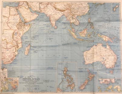
Sold2020Vintage National Geographic Magazine map of the IndianDescription: Vintage color paper map from National Geographic Magazine depicting the Indian Ocean. Copyright 1941. Material: paper. Measurement: approximate 26.5"h x 34"w (INCHES). Shipping cost: $12;See Sold Price
Sold2019Vintage National Geographic Magazine's Map of Mexico,Description: Vintage paper map from National Geographic Magazine, depicting Mexico, Central America & the West Indies. Copyright 1939. Material: paper. Measurement: approximate 33"h x 40"w (INCHES). SSee Sold Price
May 17Albion AuctionsGentleman's Magazine 1778 Canal Map. Belfast to Loughneagh Northern IrelandUS$5(1 bid)
1 day LeftHunt and Peck Estate Services, Inc.1775 John Hinton Vol. 56 "The Universal Magazine of Knowledge and Pleasure"US$50(1 bid)
1 day LeftHunt and Peck Estate Services, Inc.1749 Sylvanus Urban "The Gentleman's Magazine and Historical Chronicle"US$100
1 day LeftHunt and Peck Estate Services, Inc.1834 John Johnstone "Johnstone's Edinburgh Magazine"US$50


![Carte de la Louisiane, Maryland... 1758. Map.: [Southeastern US] Carte de la Louisiane, Maryland, Virginie, Caroline, Georgie, avec une Partie de la Floride. Amst: Covens & Mortier, 1758. C. Sepp Sculpsit:” at lower left. Labels the locations of](https://p1.liveauctioneers.com/179/122672/62428349_1_x.jpg?height=310&quality=70&version=1527272450)


![[EPHEMERA]. Group of Booklets, Magazines, Postcards, Brochu... (1 of 1)](https://p1.liveauctioneers.com/928/328184/176813372_1_x.jpg?height=282&quality=70&version=1714496988)

