Sold2022(MISSISSIPPI RIVER.) John Ross. Course of the River Mississipi, From the Balise to Fort Chartres.(MISSISSIPPI RIVER.) John Ross. Course of the River Mississipi, From the Balise to Fort Chartres. Engraved folding map of the lower Mississippi River on two sheets joined. 44¾x15 inches sheet sizSee Sold Price
Sold2021Course of the River Mississipi [sic]"Course of the River Mississipi [sic], from the Balise to Fort Chartres..." map by Lieutenant John Ross of the 34th Regiment, engraved and published with hand-colored outlines by Robert Sayer and JohnSee Sold Price
Sold2024Pre-Central Park Map of New York City, David H. Burr / Simeon DeWitt 1829Sight size 21" x 50.5" framed to 24.75" x 54.5". Some tears and seams with attempts at repair, foxing and toning, not examined out of frame.See Sold Price
Sold20211958-A Disneyland Souvenir Park Map.(Disneyland, 1958) A large souvenir map of Disneyland from 1958. This map was the first of three versions of the first-year, large format souvenir maps. This 1958-A map features subtle differences froSee Sold Price
Sold2022[MANUSCRIPT MAP-FLORIDA & MISSISSIPPI RIVER] Map Showing Raiford's Proposed Artificial River and[MANUSCRIPT MAP-FLORIDA & MISSISSIPPI RIVER] Map Showing Raiford's Proposed Artificial River and Plan to Continue the Western and Southern Inland System of Navigation to Harbors in the Atlantic. [FernSee Sold Price
Sold2016Map, Hudson River, Rev. War, Sauthier, 1776At the top of the map is written: "A Topographical Map of Hudsons River, with the Channels Depth of Water, Rocks, Shoals, &c. and the Country Adjacent, from Sandy-Hook, New York and Bay to Fort EdwardSee Sold Price
Sold2023Clyde Butcher Everglades Landscape PhotographDESCRIPTION: Clyde Butcher (American, b. 1942) Large format landscape photograph of the Everglades, shot at (Jonathan Dickinson State Park) titled: "Loxahatchee River 1" hand-printed in Clyde’sSee Sold Price
Sold2024Anna Pottery Railroad and River Guide FlaskAmerican Second Half 19th Century. Pig Shaped with river and railroad map and inscribed "With a little good old rye in hogs.."See Sold Price
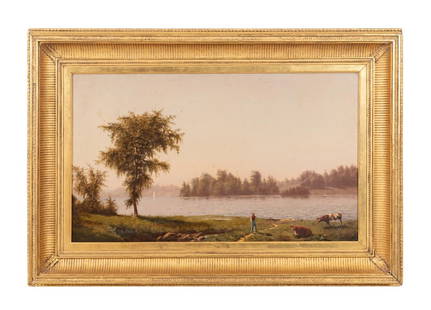
Sold2023JOHN WILLIAMSON 'HUDSON RIVER' OIL ON CANVAS, 1865John Williamson (American, 1826-1885), 'Hudson River', 1865, oil on canvas depicting a fisherman with cattle on the riverbank and a sailboat in the background, signed and dated en verso, initialed andSee Sold Price
Sold2021CLYDE ASPEVIG (AMERICAN, BORN 1951)CLYDE ASPEVIG (AMERICAN, BORN 1951) "BOW RIVER, JASPER NATIONAL PARK" OIL ON CANVAS. Image: 32" h x 48" w. Frame: 42.5" h x 58" w. Provenance: purchased from the artist for $42,000.See Sold Price
Sold2022Color map of San Francisco Chinatown 1885Heading: -1885 Author: Title: Official Map of Chinatown in San Francisco Place Published: San Francisco Publisher: Date Published: 1885 Description: Color lithographed map. 21.1See Sold Price
Sold2016Elmer Plummer, Oil on Canvas “Golf Scene” 1936Elmer Plummer, Oil on Canvas “Golf Scene” 1936 Quite spare and stark. Golfers in a beautiful landscape which includes mountains. Perhaps the inspiration was one of the courses in Griffith Park? ObSee Sold Price
Sold2024De Fer Map of the Mississippi RiverDE FER, Nicolas (1646-1720). Partie Meridionale de la Riviere de Missipi, et ses environs, dans l'Amerique Septentrionale. Mis au jour par N. de Fer. Geographe de sa Majeste Catolique 1718. Engraved mSee Sold Price
Sold2021Arto Monaco Relief Map of the Adirondack ParkNYS Map of the Adirondack Park "Just for Fun". Original 3D map. Overall size 33" x 43"See Sold Price
Sold2024John Senex Map of Louisiana & Mississippi RiverJohn Senex A Map of Louisiana and the River Mississipi [sic], London, 1721, engraving with hand coloring; English translation after Guillaume Delisle's 1718 map. Lower right reads "This map of the MisSee Sold Price
Sold2022James Richard Marquis RHA (1833 - 1885) A Busy City River Landscape at Sundown Oil on canvas, 28.3James Richard Marquis RHA (1833 - 1885) A Busy City River Landscape at Sundown Oil on canvas, 28.3 x 51.3cm (11 x 20¼) SignedSee Sold Price
Sold2022Munson's A New Map of the Western Rivers, 1846MUNSON, Sam[ue]l B[ishop] (1806-1880). A New Map of the Western Rivers. Or Travellers Guide Exhibiting the Mississippi, Missouri, Ohio, and Illinois Rivers, with all the Principal Towns, Islands & DisSee Sold Price
Sold2018PHOTOGRAPH BY ANSEL ADAMS: Half Dome, Merced River,Photograph by Ansel Adams (American, 1902-1984), gelatin silver print, Half Dome, Merced River, Winter, Yosemite National Park, 1938, likely printed 1960s; signed to lower right of mount; theSee Sold Price
Sold2022ANSEL ADAMS MERCED YOSEMITE SIGNED PHOTOGRAPHAnsel Adams (Amer. 1902 - 1984). An original signed photograph. "Early Morning, Merced River Canyon, Yosemite National Park, Ca." gelatin silver print, mounted, signed in pencil on the mount. PhotograSee Sold Price
Sold2024Alexandre AltmannUkrainian, 1885-1950Autumn at the River BankSigned Alexandre Altmann (ll)Oil on canvas71 x 53 inches (180.3 x 134.6 cm) Provenance:Family of the artistCollection of Alexander Altmann's lawyeSee Sold Price
Sold2020ALEXANDRE ALTMANN (RUSSIAN 1885-1950)ALEXANDRE ALTMANN (RUSSIAN 1885-1950) Flowers in a Park, oil on canvas 61 x 90 cm (26 x 35 1/2 in.) signed lower left PROVENANCE Sotheby's, London, June 10, 2009, lot 425 CONDITIONSee Sold Price
Sold2022H.M.S. AJAX CAPTAIN'S MAP OF THE BATTLE OF THE RIVER PLATEOriginal map depicting the Battle of the River Plate, 37 x 29 in. coated linen map fabric, prepared by Capt. Douglas H. Everett, commander of the H.M.S. AJAX only days after the December 13, 1939 engaSee Sold Price
Sold2020Keith Haring - Untitled, Drawing on New York MapKEITH HARING (1958-1990) Untitled (Crawling Baby) Ink on paper 27 1/2" x 22" Signed lower left side and inscribed "To Mike" Drawn on a 1983 New York City Transit Authority mapSee Sold Price
Sold2022SOL LEWITT (1928-2007) R706 Map of London with the area between the underground stations at Marb...SOL LEWITT (1928-2007) R706 Map of London with the area between the underground stations at Marble Arch, St. James Park, Leicester Square, Waterloo Station, Pimlico, Sloane Sq., Knightsbridge, BayswatSee Sold Price
1 day LeftThomaston Place Auction GalleriesCOLLECTION OF TRAVEL EPHEMERA, BROCHURES, BOOKLETS, MAPS 1900-1950US$100
May 31Freeman's | Hindman[AFRICAN AMERICANA - SPORTS]. Black Vs. White / Taylor Vs. McDuffee. Newark, NJ: Whitehead & HoagUS$150
Jun 23Schilb Antiquarian Rare Books1831 Northern Traveller Voyages to NIAGARA Falls Quebec Canada Illustrated MAPSUS$1
May 29Cedarburg Auction & Appraisals LLCSet of Four Maps Showing All of Spain and PortugalUS$375(2 bids)
13 hrs LeftHess Fine Auctions1885 A Popular History Of The United States JC Ridpath Gilt Green Leather Book IllustratedUS$10
4 days LeftTrillium Antique Prints & Rare BooksKarl Bodmer - Fox River, Indiana with Carolina Parrots (Extinct) & Bald Eagle. 5US$300
Featured21 hrs LeftJasper521878 Mitchell Map of Virginia and West Virginia [verso] New Jersey, Maryland and Delaware -- CountyUS$45
Featured21 hrs LeftJasper521866 Johnson's Map of Hungary, Austria, Greece and Turkey in Europe -- Johnson's Austria, Turkey inUS$60
21 hrs LeftJasper521866 McNally Map of Huge Idaho, Dakota, Colorado, Nebraska, etc -- Nebraska, Kansas, Dakota,US$70
Featured21 hrs LeftJasper521764 Bellin Map of Lesser Antilles Northern Portion -- Petites Antilles ou Isles du Vent 3e. Partie.US$130
21 hrs LeftJasper521788 Bowen Map of Ottoman Empire and Mediterranean Region -- A Correct Map of the Ottoman Empire,US$140
21 hrs LeftJasper521764 Bellin Map of Brazil from the Sao Paulo Area to Salvador -- Suite du Bresil Depuis la Baye deUS$30


![Course of the River Mississipi [sic]: "Course of the River Mississipi [sic], from the Balise to Fort Chartres..." map by Lieutenant John Ross of the 34th Regiment, engraved and published with hand-colored outlines by Robert Sayer and John](https://p1.liveauctioneers.com/1007/196938/99435775_1_x.jpg?height=310&quality=70&version=1615322535)


![[MANUSCRIPT MAP-FLORIDA & MISSISSIPPI RIVER] Map Showing Raiford's Proposed Artificial River and: [MANUSCRIPT MAP-FLORIDA & MISSISSIPPI RIVER] Map Showing Raiford's Proposed Artificial River and Plan to Continue the Western and Southern Inland System of Navigation to Harbors in the Atlantic. [Fern](https://p1.liveauctioneers.com/292/250642/130213644_1_x.jpg?height=310&quality=70&version=1654271664)


![John Senex Map of Louisiana & Mississippi River: John Senex A Map of Louisiana and the River Mississipi [sic], London, 1721, engraving with hand coloring; English translation after Guillaume Delisle's 1718 map. Lower right reads "This map of the Mis](https://p1.liveauctioneers.com/7691/320359/172153416_1_x.jpg?height=310&quality=70&version=1708543789)

![Munson's A New Map of the Western Rivers, 1846: MUNSON, Sam[ue]l B[ishop] (1806-1880). A New Map of the Western Rivers. Or Travellers Guide Exhibiting the Mississippi, Missouri, Ohio, and Illinois Rivers, with all the Principal Towns, Islands & Dis](https://p1.liveauctioneers.com/1968/250616/130196575_1_x.jpg?height=310&quality=70&version=1654190895)


![[AFRICAN AMERICANA - SPORTS]. Black Vs. White / Taylor Vs. McDuffee. Newark, NJ: Whitehead & Hoag (1 of 2)](https://p1.liveauctioneers.com/197/329785/177758448_1_x.jpg?height=282&quality=70&version=1715625218)


![1878 Mitchell Map of Virginia and West Virginia [verso] New Jersey, Maryland and Delaware -- County (1 of 2)](https://p1.liveauctioneers.com/5584/329422/177662152_1_x.jpg?height=282&quality=70&version=1715717898)


