Sold2024Ptolemy & Magini, pub. 1620 - Double Hemisphere Map of the WorldThis early map engraving is from Claudius Ptolemaeus (Ptolemy) and Giovanni Antonio Magini's Geografia cio? Descrittione Universale della Terra Partita in due volumni, Nel Primo de' quali si contengonSee Sold Price
Sold20201761 MAP OF NORTH AMERICA BY ROCQUE18th century map GENERAL MAP OF NORTH AMERICA 1754-1761 by John Rocque, London by A. Drury, 2 part map, 35.5 x 36 inches, good condition.See Sold Price
Sold2017Watercolor of tree by Zinaida SerebriakovaWatercolor of tree by Zinaida Serebriakova. Watercolor: 15"x 10" in a frame 16.5"x 11.5".(From Wiki);"Zinaida Serebriakova was born on the estate of Neskuchnoye near Kharkov (now Kharkiv, Ukraine) intSee Sold Price
Sold2016Map of North America...David H. Vance, engraved by J.H. Young. Philadelphia: Anthony Finley, 1825. Engraved map in 5 parts with original hand color in outline. 25 7/8 x 20 1/2 inches sheet, 30 5/8 x 25 1/2 inches framed.See Sold Price
Sold2022Aleksandr VYATKIN (1922-2012) Russia / UkraineAleksandr Vyatkin (1922-2012) ; Fog in the Arcticthe ; 1968 ; tempera on canvas ; unframed ; 79 x 118 cm (31 x 46,5 in.) ; signed lower right ; authors inscriptions on versoSee Sold Price
Sold2024Pictorial Map of Hollywood and Vicinity / Hollywood Film Ca...Pictorial Map of Hollywood and Vicinity / Hollywood Film Capital of the World. 1947. Los Angeles: Lowell E. Jones. Lithograph. Rare pictorial map of Hollywood with map of California on verso. PublisheSee Sold Price
Sold2023[MAP]. FRY & JEFFERSON. A Map of the Most Inhabited Part of Virginia. 1775. FIRST PRINTED MAP OF[MAPS & ATLASES]. FRY, Joshua (1699-1754) and Peter JEFFERSON (1708-1757). A Map of the Most Inhabited Part of Virginia containing the whole Province of Maryland with Part of Pensilvania, New JersSee Sold Price
Sold2015Rare Ancient Scythian Gold Jeweled Diadem ElementsNear East, from area that is modern-day Ukraine, Southern European Russia, and Crimea, ca. 5th century BCE. Comprised of three independent high karat gold elements; a central magnificent element has gSee Sold Price
Sold2017Massive Luristan Bronze Sword with Double EarsAncient Near East, Luristan or other part of northern Iran, ca. 10th to 9th century BCE. A magnificent, enormous bronze sword of the "double ear" pommel style, made using the lost wax casting techniquSee Sold Price
Sold2022John Smith Map of New England, Extremely Rare 2nd StateSMITH, John (1580-1631). New England the most remarqueable parts thus named by the high and mighty Prince Charles, Prince of great Britaine. Observed and described by Captayn John Smith... CopperplateSee Sold Price
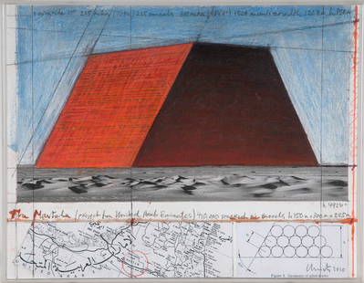
Sold2016CHRISTO & JEANNE-CLAUDE: "ABU DHABI MASTABA""ABU DHABI MASTABA (PROJECT FOR UNITED ARAB EMIRATES)"circa 2010 pencil, charcoal, oil stick, collaged aerial map and photograph on board signed and dated verso Provenance: The Estate of David Copley,See Sold Price
Sold20241776 William Burke 1st Ed 2 Volumes "An Account of the European Settlements in America"Maps at the beginning of book In Six parts. Each part contains An acurate description of the settlements in it, their Extent, Climate, Productions, Trade, Genius and Disposition of their Inhabitants;See Sold Price
SoldNine views of Ukraine, Russia and neighbouring lands: Alex Kaiser, tinted lithograph after Whitt...slight time staining, possibly trimmed, handling crease top right, one with two repaired tears bottom sheet edge; 575 x 413mm (22 2/3 x 16 1/4in)(SH); together with eight other tinted lithographs fromSee Sold Price
Sold2022A New Yorker & Bostonians Idea of the USA MapsA New Yorker & Bostonians Idea of the USA Maps, vintage maps, copyrighted to Daniel K Wallingford circa 1936, each map shows a The U.S. is reimagined through the collective and biased perspective of NSee Sold Price
Sold2018Amlash Marble Female Idol - Goddess of FertilityAncient Near East, northwestern Iran, Amlash, ca. 1200 to 800 BCE. A creamy white marble idol each with a distinctive beak-like nose, a narrow torso that widens at the waist, arms stretched outward, aSee Sold Price
Sold2023Frank Thiel, large 4-part photo, 1999-2004Frank Thiel, large 4-part photo, 1999-2004, Frank Thiel (German, b. 1966), City 7/12 (Berlin), C-print in four parts, signed, titled, dated and numbered 5/8, inscribed "4 parts" with diagram (verso),See Sold Price
Sold202413th C. Islamic Seljuq Glazed Pottery BowlNear East, Persia / Iran, Seljuq Empire (Seljuk, Saljuq), Kashan, ca. early 13th century CE. A breathtaking, intact pottery bowl presenting an inward lip and pedestal foot, all enveloped in rich turquSee Sold Price
Sold2024Rare Luristan Stone Mace Head w/ LobesAncient Near East, Northwestern Iran, Luristan, ca. 1200 to 800 BCE. An intriguing mace head of conical form bearing a trio of hemispherical lobes protruding from around the upper body. The dark graySee Sold Price
Sold2024Antique Maps of LouisianaAntique Maps of Louisiana., maps from Capt. Marcy's book Exploration of the Red River of Louisiana, 1854, incl. "Map of the Country Upon Upper Red-River", 1854, 18 3/4 in. x 36 in.; and "Map of the CoSee Sold Price
2022Blaeu, Johannes (Netherlands, 1596-1673) "The New World Map" Double Hemisphere World Map C. 1664Nova et Accuratissima Totius Terrarum Orbis Tabula Translated "The New World Map", Hand Colored w/ Elaborately Decorated Spandrels.   Sight View 16" x 21-1/2", Overall View 21" x 25-1/2"See Sold Price
Sold2022Herman Mijnerts Doncker(Dutch, 1595-circa 1656) A Family in a Landscape with Goats, circa 1620-1656, accession number verso "1867.10b", oil on fine oak panel, 37 x 55-3/8 in.; Dutch style black lacquered wood frame, 43-1/2See Sold Price
Sold2021Aurora Canero Lopez, large patinated bronzeAurora Canero Lopez (Spain, b. 1940), "Dreaming Stars II", 1998, signed, dated and numbered 2/6 verso, pedestal is part of the cast sculpture, 67.5"h x 19"w x 16"d Provenance: The Estate of Arthur MasSee Sold Price
Sold201719th C. Turkoman Crown- Silver w/ Turquoise & CarnelianWestern Central Asia (Turkmenistan, Iran, Afghanistan, Pakistan, Russia), Turkoman (Turkmen) people, ca. 19th century CE. An absolutely stunning royal crown made of a large, heavy, silver ornament sewSee Sold Price
Sold2024EUROPE. Political. Austro-Hungarian Monarchy. Shipping routes. JOHNSTON 1906 mapTITLE/CONTENT OF MAP: 'Europe' DATE PRINTED: 1906 IMAGE SIZE: Approx 33.0 x 43.5cm, 13 x 17 inches (Large); Please note that this is a folding map. TYPE: Antique colour map CONDITION: Good; suitable fSee Sold Price
5 days LeftFreeman's | Hindman[MAPS]. A group of 3 engraved maps, most with hand-coloring.US$300(1 bid)
May 29Cedarburg Auction & Appraisals LLCSet of Four Maps Showing All of Spain and PortugalUS$175(2 bids)


![[MAP]. FRY & JEFFERSON. A Map of the Most Inhabited Part of Virginia. 1775. FIRST PRINTED MAP OF: [MAPS & ATLASES]. FRY, Joshua (1699-1754) and Peter JEFFERSON (1708-1757). A Map of the Most Inhabited Part of Virginia containing the whole Province of Maryland with Part of Pensilvania, New Jers](https://p1.liveauctioneers.com/197/305583/163286504_1_x.jpg?height=310&quality=70&version=1697143109)


![[MAPS]. A group of 3 engraved maps, most with hand-coloring. (1 of 4)](https://p1.liveauctioneers.com/197/328642/177014805_1_x.jpg?height=282&quality=70&version=1714760103)


